
Nederkogel
| Nederkogel | ||
|---|---|---|
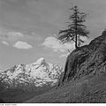
 Nederkogel of Sölden seen from |
||
| height | 3163 m above sea level A. | |
| location | Tyrol , Austria | |
| Mountains | Ötztal Alps | |
| Dominance | 2.8 km → Stockkogel | |
| Notch height | 231 m ↓ Seiter Schartle | |
| Coordinates | 46 ° 54 '25 " N , 11 ° 0' 33" E | |
|
||

The Nederkogel (also Nörderkogel , 3163 m above sea level ) is one of the dominant mountains in the inner Ötztal when looking towards the end of the valley. The free-standing summit offers a good panoramic view. To the north you can see a large part of the Ötztal. To the west there is an overview of the glacier region of the Weißkamm . To the south there is a comprehensive view of the main Alpine ridge with the famous Hochwilde or Wildspitze peaks . The view to the east gives an insight into the Stubai Alps . There is an 8 meter high summit cross on the summit.
location
The Nederkogel is the last larger peak of the Ramolkamm branching off from the main Alpine ridge Schnalskamm towards the north . In front of it is the Mittagskogel ( 2825 m above sea level ) only a smaller pre-summit. This side ridge separates the Gurgler valley from the Venter valley , which form the source valleys of the Ötztal near Zwieselstein .
route
The ascent is via the east side of the mountain. All climbs lead over the Lenzenalm ( 1896 m above sea level ). This can be reached from Zwieselstein ( 1440 m above sea level ), a fraction of the municipality of Sölden, in a good hour. There is also the possibility of starting at several points on the road leading from Zwieselstein to Obergurgl, this starting point is about 200 meters higher. Alternatively, the Alm can also be reached within an hour from Untergurgl . The ascent from the Lenzenalm to the summit takes about three to four hours. In a first, easier section, you reach the Nedersee beyond the vegetation zone. The second part of the ascent goes to a saddle in the northeast ridge of the Nederkogel, which descends to the Mittagskogel, which you enter at an altitude of 2800 m . From the saddle you reach the summit in the third section over more or less loose scree fields. Since there can be even larger snow fields in the summit region even in summer, crampons and ice ax can be advantageous.

literature
- Walter Klier : Alpine Club Guide Ötztal Alps . Bergverlag Rudolf Rother, Munich 2006. ISBN 3-7633-1123-8 .
- Compass map 043 Ötztal Alps - Ötztal, Pitztal . 1: 50000 (with booklet), ISBN 978-3-85491-049-7 .
- Compass map 042 Inneres Ötztal - Gurgler Tal, Venter Tal, Pitztal . 1: 25000 (with booklet), ISBN 3-85491-600-0 .

Nederkogel, summit region

Nedersee

Mittagskogel

Lenzenalm

View from the Giggijochbahn mountain station (2284 m) in winter
historical recording


