Gurgl
|
Gurgl ( locality ) locality |
||
|---|---|---|
|
|
||
| Basic data | ||
| Pole. District , state | Imst (IM), Tyrol | |
| Judicial district | Silz | |
| Pole. local community | Soelden | |
| Coordinates | 46 ° 52 '12 " N , 11 ° 1' 35" E | |
| height | 1907 m above sea level A. | |
| Residents of the village | 452 (January 1, 2020) | |
| Postcodes | 6450, 6456 Obergurgl | |
| Statistical identification | ||
| Locality code | 16449 | |
| Counting district / district | Gurgl-Vent-Zwieselstein (70220 001) | |
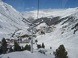
 Obergurgl seen from the Hohe Mut Bahn |
||
| Source: STAT : index of places ; BEV : GEONAM ; TIRIS | ||
Gurgl is a fraction of the municipality of Sölden in the Imst district in Tyrol with 452 inhabitants (as of January 1, 2020). It consists of the village of Obergurgl and numerous smaller settlements.
geography
Gurgl is located in the Ötztal Alps near the main Alpine ridge and is surrounded by peaks up to 3500 m high and several glaciers, the largest of which is the Gurgler Ferner . The settlements are in the Gurgler Valley at an altitude of 1770 m above sea level. A. up to 2154 m above sea level A. (Hochgurgl), Obergurgl is 1907 m above sea level. A. as the highest church village in Austria.
The village of Gurgl includes the village of Obergurgl, the hamlets of Dreihäusern, Pill and Poschach, the Rotten Angern, Hochgurgl, Kressbrunnen, Pirchhütt and Untergurgl as well as the refuge huts Fidelitashütte , Hochwildehaus , Karlsruher Hütte and Ramolhaus .
climate
Protected by the high mountain ranges, Gurgl has a relatively dry inner-alpine climate. The annual mean of the precipitation (period 1971–2000) at the measuring point Obergurgl ( 1938 m above sea level ) is 819 mm. The daily maximum was measured on May 22, 1983 at 87 mm. On average there are 198 days with snow cover.
|
Average monthly temperatures and precipitation for Obergurgl
|
|||||||||||||||||||||||||||||||||||||||||||||||||||||||||||||||||||||||||||||||||||||||||||||||||||||||||||||||||||||||||||||||||||||||||||||||||||||||||||||||||||||||||
history
The name Gurgl is traced back to Gurgall , which should mean something like “place in the glacier crown ”. The traces of the first settlement go to 7500 BC. Back to about 4500 BC. There is evidence of slash and burn and pasture farming in the Obergurgl area. Settlement did not come from the Inntal via the Ötztal , but from the Vinschgau via the main Alpine ridge. Gurgl was first mentioned in 1250 when a "Heberhardus von Gurgele", a servant of the Vinschgau lords of Montalban , was named in a document. Gurgl originally belonged to the Passeier court , from 1286, like the rest of the Ötztal, to the Petersberg court .
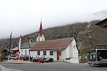
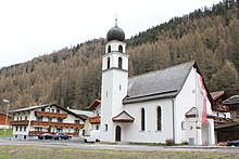
Like Sölden, Gurgl originally belonged to the original parish of Silz . In 1727 it became a chaplain, in 1769 a curate , and in 1891 it was elevated to an independent parish. In 1737 the church of St. Johannes Nepomuk , which was expanded in 1967 according to plans by Clemens Holzmeister . From 1856 to 1864, Adolf Trientl was curate in Obergurgl. The parish of Gurgl also includes the chapel dedicated to St. Josef in Untergurgl and the chapel in Hochgurgl.
On May 27, 1931, Auguste Piccard landed after setting a new altitude record with the balloon on Gurgler Ferner, where he had to spend one night before being recovered from Obergurgl. A memorial erected in 1989 commemorates this landing.
In the 20th century Gurgl developed into a winter sports resort, in 1949 the first drag lift was built in Obergurgl, followed by the chair lift to the Hohe Mut in 1953. In 1960 the Timmelsjoch High Alpine Road was completed and the hotel village Hochgurgl built.
Gurgl was often affected by natural disasters, especially avalanches, which led to the destruction of buildings and fatalities. In January 1951, for example, all buildings, including the church in Untergurgl and Angern, were destroyed by avalanches, killing seven residents. Up until the 19th century, the regular eruption of the Gurgler ice lake caused devastation in the entire Gurgler valley.
Economy and Infrastructure
Agriculture is only possible under difficult conditions and used to be barely enough to feed the population. Due to the altitude and the short growing season, no grain cultivation is possible.
Due to old laws, sheep from South Tyrol graze above Gurgl every summer, which are driven over the mountains from the Passeier . The route used to run over the Gurgler Ferner, today over the Timmelsjoch .
The tourism brought a fundamental change in the 20th century. Today there are over 4,000 guest beds in Gurgl and around 85,000 guests are accommodated annually. Obergurgl and Hochgurgl have an extensive ski area with 25 lifts and 112 kilometers of slopes.
The University of Innsbruck operates the Alpine Research Center Obergurgl, which has been conducting research on meteorology , glacier research , vegetation , as well as altitude and sports medicine since 1951 . The former federal sports center was converted into the Obergurgl University Center and is now used as a research, conference and congress center.
literature
- Eva-Maria Koch and Brigitta Verschbamer (eds.): Glacial and periglacial habitats in the Obergurgl area . Innsbruck University Press, Innsbruck 2010, ISBN 978-3-902719-50-8 .
Web links
- Entry on Obergurgl in the Austria Forum (in the AEIOU Austria Lexicon )
- Sölden , in the history database ofthe association "fontes historiae - sources of history"
- Chronicle of the Ötztal on oetztal.at
Individual evidence
- ↑ Statistics Austria: Population on January 1st, 2020 by locality (area status on January 1st, 2020) , ( CSV )
- ↑ Central Institute for Meteorology and Geodynamics: Climate data from Austria 1971–2000
- ↑ Office of the Tyrolean Provincial Government (Ed.): Statistisches Handbuch Bundesland Tirol 2009 , pp. 50–52 ( PDF; 9.3 MB )
- ↑ a b The shaft drive in the Ötztal (PDF; 315 kB)
- ↑ Tirol Atlas: Natural History Tyrol
- ↑ Luis Pirpamer: natural event avalanche: a natural occurrence . In: R. Lackner, R. Psenner, M. Walcher (eds.): Is it the Sindt river? Cultural strategies & reflections for the prevention and management of natural hazards. alpine space - man & environment, vol. 4. Innsbruck University Press, Innsbruck 2008, ISBN 978-3-902571-32-8 , pp. 75-84. ( PDF; 2.7 MB )
- ↑ Tirol Werbung: Obergurgl-Hochgurgl - general information ( Memento from September 28, 2013 in the Internet Archive )
- ↑ Facts about the ski area , obergurgl.com
- ^ University of Innsbruck: The History of the Alpine Research Center Obergurgl


