Inner spring tip
| Inner spring tip | ||
|---|---|---|
|
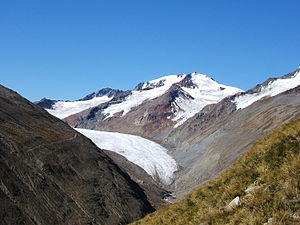
Inner spring peak (left) and Weißkugel from the east |
||
| height | 3516 m above sea level A. | |
| location | Austria , Tyrol ; Italy , South Tyrol | |
| Mountains | Ötztal Alps | |
| Dominance | 0.42 km → Weißkugel | |
| Notch height | 73 m ↓ Hintereisjoch | |
| Coordinates | 46 ° 47 '18 " N , 10 ° 43' 48" E | |
|
|
||
The inner spring peak is 3516 m above sea level. A. high mountain in the Ötztal Alps in the Schnalskamm near the Weißkugel . The summit is exactly on the border between the Italian province of South Tyrol and the Austrian state of Tyrol . At the Innere Quellspitze, the Saldurkamm branches off to the south from the Schnalskamm and finds its first peak in the Äußere Quellspitze ( 3385 m ).
The Innere Quellspitze can be climbed from the Hintereisjoch via the north ridge in half an hour, or from the Quelljoch in an hour via the south ridge. Both climbs require climbing grade II on the UIAA scale .
The name of the mountain is clearly of more recent, alpine origin, as well is actually used for the standard language word source in the local dialect .
Web links
Individual evidence
- ^ Walter Klier, Alpine Club Guide Ötztaler Alpen , 12th edition, Bergverlag Rudolf Rother , Munich 1995, ISBN 3-7633-1123-8 , p. 397.
- ↑ Johannes Ortner: Matscher name hike . In: Experience the mountains - The magazine of the Alpine Association of South Tyrol . No. 1 , 2019, p. 62-63 .

