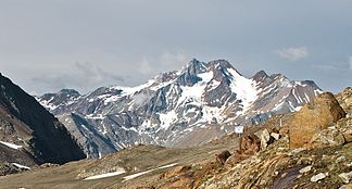
Saldurkamm
| Saldurkamm | |
|---|---|
|
Saldurkamm with the double peaks Lagaunspitze (left) and Saldurspitze (right) seen from the north |
|
| Highest peak | Schwemser peak ( 3459 m ) |
| location | South Tyrol ( Italy ) |
| part of | Ötztal Alps |
| Coordinates | 46 ° 46 ′ N , 10 ° 44 ′ E |
The Saldurkamm (also Salurnkamm ) is a mountain ridge in the south of the Ötztal Alps . It is located in the Italian province of South Tyrol between the Etschtal or Vinschgau in the south, the Matscher valley in the west and the Schnalstal in the east.
The ridge branches off at the Innere Quellspitze ( 3516 m ) southwards from the Schnalskamm , part of the main Alpine ridge , and branches off at the Ramudlaspitze ( 3366 m ) into a south-east and a south-west ridge. The Schlandraun valley lies between the two branches . In the northern part of the ridge are the eponymous Saldurspitze ( 3433 m ) and the highest mountain of the entire ridge, the Schwemser Spitze ( 3459 m ).
Important peaks
Some significant peaks of the Saldur ridge are (in order of height):
| summit | Height (meters) |
|---|---|
| Schwemser tip | 3459 m slm |
| Lagaunspitze | 3439 m slm |
| Saldurspitze | 3433 m slm |
| Saldurkopf | 3429 m slm |
| High alt | 3285 m slm |
| Mastaunspitze | 3200 m slm |
literature
- Walter Klier : Alpine Club Guide Ötztaler Alpen , Bergverlag Rudolf Rother , Munich 2006. ISBN 3-7633-1123-8
