
Front oil pit tip
| Front oil pit tip | ||
|---|---|---|
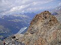
 View from Krummgampental to the Vordere Ölgrubenspitze |
||
| height | 3452 m above sea level A. | |
| location | Tyrol , Austria | |
| Mountains | Ötztal Alps | |
| Dominance | 1.46 km → Bliggspitze | |
| Notch height | 242 m ↓ Bliggschartl | |
| Coordinates | 46 ° 54 ′ 0 ″ N , 10 ° 46 ′ 0 ″ E | |
|
||
| First ascent | August 17, 1876 by Johann Praxmarer and Ignaz Schöpf with the "hut landlady of the Gepatschhaus " | |
| Normal way | from the south over the Südscharte ( II ) | |

The front oil pit tip is 3452 m above sea level. A. high mountain of the Kaunergrat in the Ötztal Alps in Tyrol . It is separated from the Hinteren Ölgrubenspitze by the 3044 m high Ölgrubenjoch. The Ölgrubenkopf lies in the ridge that extends south to the Ölgrubenjoch.
The Vordere Ölgrubenspitze has two peaks, the south summit at 3452 m and the lower north summit at 3451 m .
The Vordere Ölgrubenspitze is extremely rewarding because of its outstanding view, but requires mountaineering skills and mountaineering experience. Its boldly towering summit structure made of gray rock gives it an unmistakable sight.
Ascent history
The first ascent of the southern summit took place on August 17, 1876 by the mountain guides Johann Praxmarer and Ignaz Schöpf with the "hut landlady of the Gepatschhaus ". They climbed through the small Hochkar north of the Ölgrubenjoch to the ridge height south of the summit and won the summit over the southern ridge of the mountain.
The north summit was conquered on August 8, 1881 by John Percy Farrar , with Johann Praxmarer as a mountain guide, the first to climb the south summit.
Routes
The normal route leads from the Taschachhaus on the way to the Ölgrubenjoch to the plateau with the glacial lakes. There you leave the path and come up north-west through wide debris lanes. You continue along a stream to a glacier remnant, which you bypass or cross. Above it, an earthy channel leads to the ridge ( UIAA I ) and, crossing the oil pit head, into the southern notch of the Vorderen Ölgrubenspitze. When descending into the saddle, you avoid a steeper ridge drop in the western flank (rubble channels, UIAA I) or stay directly on the ridge (UIAA II).
On the ridge you now climb up to the steep, gray summit of the Ölgrubenspitze. Thereby you overcome a smaller, brittle rock step. Finally, turn left to a steep gully that descends from the summit and rises steeply in it (UIAA II, extremely fragile) to the summit with a summit cross and summit book.

Summit construction of the oil pit tip from the south

On the south ridge
The north summit

Oil pit top from the southeast
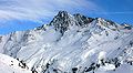
Oil pit top in winter

Ölgrubenspitze with peaks in the Kaunergrat and Weißkamm


Web links
Individual evidence
- ↑ Clem Clements, Jonathan de Ferranti, Eberhard Jurgalski , Mark Trengove: The 3000 m SUMMITS of AUSTRIA - 242 peaks with at least 150 m of prominence , October 2011, p. 8. Height of the reference chart according to: Walter Klier: Alpenvereinsführer Ötztaler Alpen, Munich 2006, RZ 1791.
- ↑ Federal Office for Metrology and Surveying Austria: Vordere Ölgrubenspitze on the Austrian Map online (Austrian map 1: 50,000) .
- ↑ Ludwig Obersteiner: Guide through the Ötztal Alps , Reichenstein-Verlag, Vienna, 1925, p. 70
- ^ Walter Klier : Alpenvereinsführer Ötztaler Alpen , Bergverlag Rudolf Rother , Munich 2006, p. 246. ISBN 3-7633-1123-8