
Vorderer Brochkogel
| Vorderer Brochkogel | ||
|---|---|---|
 Vorderer Brochkogel (right) |
||
| height | 3565 m above sea level A. | |
| location | Tyrol , Austria | |
| Mountains | Ötztal Alps , Weißkamm | |
| Dominance | 1.24 km → Hinterer Brochkogel | |
| Notch height | 165 m ↓ Vernagtjoch | |
| Coordinates | 46 ° 52 '30 " N , 10 ° 51' 2" E | |
|
||
| rock | Gneiss , mica slate | |
| First ascent | 1851 as part of the military land surveying, in 1861 or 1862 by Franz Senn , Eduard Neurauter, Johann Kuprian and Johann Karlinger, led by Benedict Klotz | |
| Normal way | Südgrat, from the Breslauer Hütte or the Vernagthütte | |

The Vordere Brochkogel is 3565 m above sea level. A. high mountain in the Weißkamm in the Ötztal Alps . It is located in the Austrian state of Tyrol and is the sixth highest peak in the Ötztal Alps. It was first committed in 1851 as part of the military land survey. 1861 or 1862 then took the first tourist ascent by the founder of the German Alpine Club , the priest Franz Senn with the student Eduard Neurauter, Johann Kuprian and Johann Karlinger that Benedict Klotz led . There is different information about the year of this first ascent of the Vorderen Brochkogel. Franz Senn writes the year 1861 in his tourist calendar 1869 for his ascent , while Theodor Petersen states 1862 in the magazine of the German and Austrian Alpine Association .
Location and surroundings
The Vordere Brochkogel is about five kilometers as the crow flies west of Vent , a good two kilometers west above the Breslauer Hütte . Neighboring peaks are in the north, separated by the Vernagtjoch ( 3400 m ), the Hintere Brochkogel with 3635 m and in the northeast the Wildspitze with 3768 m . To the south, the Vordere Brochkogel drops south-east into the Rofental and sends out a side ridge that carries the Platteikogel ( 3426 m ) and borders the Vernagtbach valley to the east, which also descends to the Rofental.
Base and ascent

The normal route , the easiest ascent, leads to the summit over the south ridge from the Breslauer Hütte , at an altitude of 2,844 meters. The route initially runs from the hut in a westerly direction on the marked path no. 919 ( Seuffertweg ) to Platteibach . Then it goes further north along the east bank over rubble to the exposed summit ridge in, according to literature, easy climbing of difficulty UIAA I to the summit. The path is quite precisely marked with cairns, but sometimes the cairns can hardly be seen in the upper area. First you reach the pre-summit (approx. 3550 m ), the main summit is approx. 120 m away, the path leads over the narrow and exposed summit ridge. According to the literature, the walking time is around 2½ hours. From the Vernagthütte ( 2766 m ), the ascent, initially following the Seuffertweg in an easterly direction, can be done in three hours.
view
Due to its height, the mountain offers a wide view that is only obstructed in the northeast by the two very close, higher mountains Hinterer Brochkogel and Wildspitze (between the two, the Zugspitze looks out among other things ). To the east you can see the Großvenediger , the Riesenferner group , the Zillertal Alps and the Hochschober 141 km away . In the southeast are the Dolomites , in the south the Presanella and in the southwest the mountains of the Ortler and Bernina groups . In the west, the view can extend to the Aletschhorn, 223 km away, and many other peaks in the Bernese Alps . To the right of these you can see the Tödi and many other peaks of the Glarus Alps , the Silvretta , the Rätikon , the Verwall , the Lechquellen Mountains and the Lechtal Alps .
Literature and map
- Walter Klier , Alpine Club Leader Ötztaler Alpen , Munich 2006, ISBN 3-7633-1123-8
- Alpine club map 1: 25,000, sheet 30/1 Ötztal Alps, Gurgl
photos
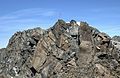
summit
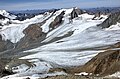
View towards Vernagtferner with the Hochvernagtspitze

Platteikogel (left in the background) and Vorderer Brochkogel seen from the Mitterkar
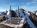
Foundation on the pre-summit


Web links
Individual evidence
- ^ Theodor Petersen in the magazine of the German and Austrian Alpine Association , Volume VII, Munich 1876, p. 222
- ^ Franz Senn: Tourist Calendar 1869 , p. 301
- ^ Walter Klier: Alpine Club Guide Ötztaler Alpen , Munich 2006, p. 313 f.
- ↑ PeakFinder Ltd [email protected]: Mountain panorama: Vorderer Brochkogel. Retrieved July 7, 2019 .