Hochschober
| Hochschober | ||
|---|---|---|
|
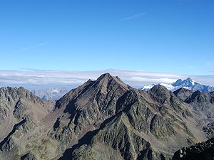
Hochschober from the south ( High Prijakt ) |
||
| height | 3242 m above sea level A. | |
| location | Tyrol , Austria | |
| Mountains | Schobergruppe | |
| Dominance | 4.97 km → Red button | |
| Notch height | 433 m ↓ Kalser Törl | |
| Coordinates | 46 ° 56 '34 " N , 12 ° 41' 54" E | |
|
|
||
| First ascent | August 18, 1852 by Franz Keil with guide Paul Oblasser and entourage | |
| Normal way | From the south to the Staniskascharte, then over the west ridge ( I ) | |
|
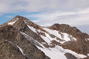
Hochschober with Schoberkees from the northeast ( Debantgrat ) |
||
The Hochschober is with a height of 3242 m above sea level. A. the fourth highest and eponymous mountain of the Schober group in the Hohe Tauern . Its glaciated northern flank is an impressive sight from Kals . When the geographer Adolf Schaubach introduced the Schobergruppe as a mountain group in 1845 , he chose the name after the Hochschober because he mistakenly believed it to be the highest mountain south of the Peischlachtörl.
The easiest ascent is via the Hochschoberhütte ( 2322 m ) from the south over the Staniskascharte ( 2936 m ) and the west ridge. An ascent possibility of comparable difficulty is offered from the east and the upper part of the southeast ridge. The latter route is ideal when using the Lienzer Hut ( 1977 m ) as a base. Both ascent trails are marked and in midsummer, in contrast to earlier years, are usually free of snow, have slight climbing difficulties ( I ) and are somewhat exposed in places. Another way to climb is the partially marked climb from Schobertörl ( 2898 m ) over the northeast ridge, crossing the Kleinschober ( 3125 m ).
Individual evidence
- ↑ Clem Clements, Jonathan de Ferranti, Eberhard Jurgalski , Mark Trengove: The 3000 m SUMMITS of AUSTRIA - 242 peaks with at least 150 m of prominence , October 2011, p. 16.
- ^ Federal Office for Metrology and Surveying Austria: Hochschober on the Austrian Map online (Austrian map 1: 50,000) .
- ^ Adolf Schaubach: The German Alps , Volume I, Jena 1845, pp. 70–78
Literature and map
- Alpine club map sheet 41, 1: 25,000, Schobergruppe , ISBN 3-928777-12-2
- Richard Goedeke : 3000er in the Northern Alps , Bruckmann, Munich 2004, ISBN 3-7654-3930-4
- Walter Mair: Alpine Club Leader Schobergruppe . Bergverlag Rudolf Rother , Munich 1979. ISBN 3-7633-1222-6


