
Peak
|
Pitze Pitzbach |
||
 Middle course of the peak |
||
| Data | ||
| Water code | AT : 2-8-84 | |
| location | Pitztal , Ötztal Alps ; Imst district , Tyrol | |
| River system | Danube | |
| Drain over | Inn → Danube → Black Sea | |
| origin | from Mittelbergferner 46 ° 55 ′ 58 ″ N , 10 ° 54 ′ 5 ″ E |
|
| Source height | approx. 2400 m above sea level A. | |
| muzzle | at Karres in the Inn Coordinates: 47 ° 12 ′ 48.4 ″ N , 10 ° 46 ′ 46 ″ E 47 ° 12 ′ 48.4 ″ N , 10 ° 46 ′ 46 ″ E |
|
| Mouth height | 705 m above sea level A. | |
| Height difference | approx. 1695 m | |
| Bottom slope | approx. 42 ‰ | |
| length | 40.5 km | |
| Catchment area | 308.7 km² | |
| Outflow at the Ritzenried gauge. A Eo : 132.2 km² Location: 12.83 km above the mouth |
NNQ (03/18/2000) MNQ 1981/2009 MQ 1981/2009 Mq 1981/2009 MHQ 1981/2009 HHQ (08/25/1987) |
150 l / s 670 l / s 4.18 m³ / s 31.6 l / (s km²) 32.6 m³ / s 78.1 m³ / s |
| Left tributaries | Taschachbach, Lussbach , Loabach, Seebach, Pfitschebach, Sagebach, Saxuirer Bach, Söllbach, Markbach, Klausbach, Schildbach, Pillerbach, Grillerbach, Ehrenbach | |
| Right tributaries | Schneelehnbach, Praschlehnbach, Kitzlesbach , Murlehnbach, Hundsbach, Schitzbach, Klockelebach, Almbach, Ronachbach, Bichlbach, Hairlacher Bach, Stuibenbach, Mühlbach | |
| Communities | St. Leonhard im Pitztal , Wenns , Jerzens , Arzl im Pitztal | |
The Pitze (also Pitzbach ) is a right tributary of the Inn . It flows through the Pitztal in Tyrol and has a length of approx. 40 km.
Its catchment area is about 309 km².
The origin lies on the northern roof of the main Alpine ridge on the Mittelbergferner in the municipality of St. Leonhard im Pitztal . The Wildspitze at 3768 m is considered to be the highest point in the catchment area. The confluence with the Inn lies at 705 m between Arzl im Pitztal and Karres .
46 glaciers with an area of 35 km² cover more than ten percent of the catchment area. The water flow, however, does not correspond to the size of the area, because since 1964 it has been captured in its upper course and directed to the Gepatsch reservoir in the Kaunertal . Only in the uppermost area of the catchment area does the peak show a natural water flow characterized by strongly changing flow conditions.
In the summer months, the snow and glacier melt transforms the Pitze into a thundering glacier stream, even in a year with little rainfall, the water flow is highest in June, July and August. In the approaching autumn, the water flow drops sharply in September. The causes are the lower temperatures, the lower precipitation and the occasional lowering of the snow line. The low temperatures, which sometimes set in as early as November, cause the watercourses to freeze and, if the temperatures persist, ground ice forms, which can lead to a dangerous rise in the water level. The water flow of the peak reaches its minimum in the months of February or March.
Since the construction of the water intake at an altitude of 1,800 m, the peak has disappeared in a tunnel there ; there is only overwater at the intake point on a few days. The transfer tunnel also takes water from the Taschachbach , the largest feeder of the Pitze, to the Gepatsch reservoir . At Wenns it is caught a second time and fed to the TIWAG power station in Imst , making the remaining catchment area 30.5 km².
The settlements in the area of the inner and central Pitztal are repeatedly affected by significant flood events, while the lower reaches are hardly at risk of flooding because the Pitze flows here in a gorge-like channel, the Arzler Pitzeklamm , and the settlements are built on higher terraces.
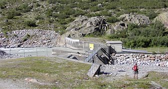
Tyrolean weir which the Pitze the Kaunertal power plant derives

View of the inner Pitztal, out of the valley
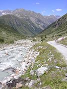
Upper course of the Pitze

Arzler Pitzeklamm, shortly before the confluence with the Inn


Web links
Individual evidence
- ↑ a b c TIRIS - Tyrolean regional planning and information system
- ↑ Land Tirol: Hydrographic characteristics
- ↑ Federal Ministry for Agriculture, Forestry, Environment and Water Management (ed.): Hydrographisches Jahrbuch von Österreich 2009. 117th volume. Vienna 2011, p. OG 93, PDF (12.1 MB) on bmlrt.gv.at (yearbook 2009)