Mandarps
| Mandarfen ( hamlet ) | ||
|---|---|---|
|
|
||
| Basic data | ||
| Pole. District , state | Imst (IM), Tyrol | |
| Pole. local community | St. Leonhard im Pitztal ( KG Pitztal ) | |
| Locality | Plangeross | |
| Coordinates | 46 ° 58 '7 " N , 10 ° 52' 17" E | |
| height | 1675 m above sea level A. | |
| Post Code | 6481 | |
| Statistical identification | ||
| Counting district / district | St.Leonhard-Süd (70217 001) | |
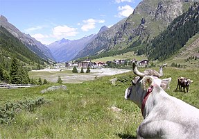
 View of Mandarfen, out of the valley to the north |
||
| Source: STAT : index of places ; BEV : GEONAM ; TIRIS | ||
Mandarfen is a hamlet in the municipality of St. Leonhard im Pitztal , is located at 1675 m above sea level and has developed into one of the most important tourist spots in the valley in recent years. Originally the place was just an alpine pasture and only inhabited in summer. Today, several hotels in the 4-star and 3-star categories as well as holiday apartments and private room renters offer space for up to 900 guests.
There is a glacier ski area on the Pitztal Glacier with a maximum slope height of 3440 m and the Rifflsee ski area with a maximum slope height of 2800 m . In the valley there is a practice or. Button lift.
The landmark is the highest ice climbing tower in the Alps, popularly called “Big Ben” after the famous ski racer Benjamin Raich .
literature
- Klaus Peter Arnold: Tourism in the Tyrolean Oberland. Epubli GmbH, Berlin 2014, ISBN 978-3-8442-9105-6 .
