Open space
| Open space | ||
|---|---|---|
|
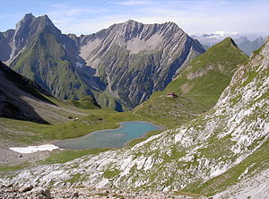
Freispitze (left), in front of this the Jägerücken and Saxerspitze ( 2690 m ); |
||
| height | 2884 m above sea level A. | |
| location | Tyrol , Austria | |
| Mountains | Lechtal Alps | |
| Dominance | 4.5 km → Wetterspitze | |
| Notch height | 280 m ↓ Parseierscharte | |
| Coordinates | 47 ° 12 '2 " N , 10 ° 25' 43" E | |
|
|
||
| Age of the rock | Triassic (Rhät) | |
| First ascent | Tourist ascent August 19, 1878 by Anselm Klotz and Anton Sattler | |
| Normal way | From the Memminger Hütte in 5 hours via the southeast flank | |
The free tip is 2884 m above sea level. A. high mountain in the Lechtal Alps in the Austrian state of Tyrol . It forms an approximately two-kilometer-long north-east to south-west massif with rock walls up to 600 meters high. It appears as Freyspitz on Peter Anich's historical map of Tyrol from 1774 . The first documented ascent of the Freispitze took place on August 19, 1878 by Anselm Klotz , from Stockach (near Bach in Tyrol ), the first Lechtal mountain guide authorized by the Alpine Association in 1885 , and the Salzburg lawyer and mountain panorama artist Anton Sattler. However, Klotz was already on the summit in 1873 with his companion Josef Frey.
Location and surroundings
The mountain is a good seven kilometers as the crow flies south of the municipality of Bach im Lechtal and about four kilometers west of the Memminger Hütte . Adjacent peaks are in the north, separated by the Karlescharte , the Saxerspitze with an altitude of 2690 meters, in the south the Grießlspitze (2830 m) and in the southwest the 2837 meters high Rotspitze .
Geology and particularities
With its impressive width of two kilometers, its angular shape and the walls that are up to 600 meters high, the Freispitze has a great geographical dominance over its surroundings. Above all, the 500-meter-high south wall made of hard limestone of the Oberrät geological level makes this mountain an interesting destination for climbers . The geological diversity is evident on the east ridge with hard aptych limestone from the Upper Jura . The summit formation consists of limestone from the upper Triassic of the Kössen strata . In the southeast pillar of the Freispitze there is rock from the Rät and in the southwest you can find large areas with spotted marl .
Support points and routes for ascent
The path of the first climbers in August 1879 led from the Alperschontal and Alperschonalpe over the west side to the summit in about seven hours. The Ansbacher Hut and the Memminger Hut (2242 m) serve as bases for today's ascent of the secluded and therefore not overrun by tourists . The normal route , the most commonly used today increase the free tip leads from the Memminger hut with large height loss initially down into Parseiertal , then northwest up to the Schafgufel in 2000 meters altitude, then no trail through the Parseiergrieß south on Southeast pillars of the free tip over and over steep marl Schrofen in the southern Freispitzscharte . There it goes over a small slip in the wall over rubble, then solid rock to the summit. The duration of the tour is at least five hours. According to the literature, there are climbing spots with a UIAA II + to III- difficulty level on this by no means easy climb . The path from the Ansbacher Hütte crosses the Rotspitze (2837 meters) and the Rote Platte (2831 meters) and is one of the most impressive tours in the Lechtal Alps. Another and much easier ascent leads from the north over the three notches and the west ridge to the summit. The Freispitze can also be climbed from the Parseiertal directly over the Jägerback . The ascent of a total of 1600 meters of altitude offers over 1000 meters of altitude with rather easy climbing in very exposed and mostly grassy crags . The key point is the crossing of the north face, difficulty level UIAA IV , just below the summit .

The south face was climbed relatively late in 1969 because of its secluded and inaccessible location (level of difficulty UIAA VI). Even today, it is best for climbing ventures to bivouac below the wall in Parseiergriess . In Tyrol, however, as in almost the entire Alpine arc, this is only allowed in emergency situations as an emergency bivouac.
Literature and map
- Dieter Seibert: Alpine Club Guide Lechtaler Alpen , Munich 2008, ISBN 978-3-7633-1268-9
- Alpine club map 1: 25,000, sheet 3/3, Lechtal Alps, Parseierspitze
Individual evidence
- ↑ a b Journal of the German and Austrian Alpine Association , Volume X, Munich 1879, p. 251 ff.
- ^ Raimund von Klebelsberg : Geologie von Tirol , Berlin 1935, p. 72 u. 417
- ↑ Dieter Seibert: Alpine Club Guide Lechtaler Alpen , Munich 2008, p. 242 ff.
- ↑ Camping and bivouacking in the mountains can be expensive. derstandard.at, accessed on March 21, 2018 .

