Elmen
|
Elmen
|
||
|---|---|---|
| coat of arms | Austria map | |
|
|
||
| Basic data | ||
| Country: | Austria | |
| State : | Tyrol | |
| Political District : | Reutte | |
| License plate : | RE | |
| Surface: | 29.6 km² | |
| Coordinates : | 47 ° 20 ' N , 10 ° 33' E | |
| Height : | 976 m above sea level A. | |
| Residents : | 383 (January 1, 2020) | |
| Population density : | 13 inhabitants per km² | |
| Postal code : | 6644 | |
| Area code : | 05635 | |
| Community code : | 7 08 09 | |
| NUTS region | AT331 | |
| Address of the municipal administration: |
Elmen Br. 2 6644 Elmen |
|
| Website: | ||
| politics | ||
| Mayor : | Heinrich Ginther | |
|
Municipal Council : (2016) (1 members) |
||
| Location of Elmen in the Reutte district | ||
 Elmen from the southwest |
||
| Source: Municipal data from Statistics Austria | ||
Elmen is a municipality with 383 inhabitants (as of January 1, 2020) in the Reutte district in Tyrol ( Austria ). The community is located in the judicial district of Reutte on the right bank of the Lech Valley . Elmen is a densely built-up cluster village on an alluvial cone . The place was first mentioned in 1312 as Elmenoe , Ellmo , Elbnau (Au with elms).
Elmen is freed from through traffic by a bypass road. A popular excursion destination is the Stablalpe above. The Martinau fraction on the left bank of the Lech also belongs to the community. In floodplain end of May blooms on a large area of the rare lady's slipper .
Neighboring communities
Häselgehr , Hinterhornbach , Pfafflar , Stanzach , Vorderhornbach .
Community structure
The municipality includes the following three localities (residents as of January 1, 2020):
- Elmen (331)
- Klimm (8)
- Martinau (44)
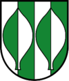
coat of arms
Blazon : Shield split three times from silver and green with two elm leaves in confused colors.
The municipal coat of arms, awarded in 1973, shows two stylized elm leaves and thus symbolizes the place name, which comes from "elm", as a talking coat of arms .
Culture and sights
- Parish Church of the Three Kings with a cemetery and a war memorial. The artist Johann Anton Falger , who comes from the neighboring Elbigenalp, also painted a dance of death for Elmen in 1841, which was originally installed in niches in the cemetery wall and is now kept in the death chapel. The picture cycle consists of 12 small-format wooden panels (35 × 23 cm) with associated dialogues. The following are shown in the order: grandmother, beggar, lumberjack, maid, prince, citizen, child, boy, soldier, bride, farmer, priest.
- Field Chapel Holy Trinity
- Filial church St. Joseph in Martinau
- Chapel 14 Holy Helpers
Web links
- 70809 - Elmen. Community data, Statistics Austria .
- Elmen , in the history database ofthe association "fontes historiae - sources of history"
Individual evidence
- ↑ Statistics Austria: Population on January 1st, 2020 by locality (area status on January 1st, 2020) , ( CSV )
- ^ Eduard Widmoser: Tiroler Wappenfibel . Tyrolia-Verlag, Innsbruck 1978, ISBN 3-7022-1324-4 , p. 64 .
- ↑ Hans Georg Wehrens: The dance of death in the Alemannic language area. "I have to do it - and don't know what" . Schnell & Steiner, Regensburg 2012, ISBN 978-3-7954-2563-0 . P. 260f.


