
Pinswang
|
Pinswang
|
||
|---|---|---|
| coat of arms | Austria map | |
 |
|
|
| Basic data | ||
| Country: | Austria | |
| State : | Tyrol | |
| Political District : | Reutte | |
| License plate : | RE | |
| Main town : | Unterpinswang | |
| Surface: | 9.37 km² | |
| Coordinates : | 47 ° 33 ' N , 10 ° 40' E | |
| Height : | 824 m above sea level A. | |
| Residents : | 405 (January 1, 2020) | |
| Population density : | 43 inhabitants per km² | |
| Postal code : | 6600 | |
| Area code : | 05677 | |
| Community code : | 7 08 27 | |
| NUTS region | AT331 | |
| Address of the municipal administration: |
Unterpinswang 1 b 6600 Pinswang |
|
| Website: | ||
| politics | ||
| Mayor : | Karl Wechselberger | |
|
Municipal Council : (2016) (11 members) |
||
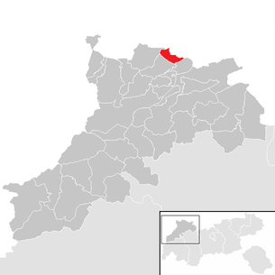
| Location of Pinswang in the Reutte district | ||
  |
||
| Source: Municipal data from Statistics Austria | ||

Pinswang is a municipality with 405 inhabitants (as of January 1, 2020) in the Reutte district in Tyrol ( Austria ).
Pinswang is located on the eastern side of a basin-like extension of the Lech north of Reutte. The settlement area is divided into the districts of Oberpinswang, Unterpinswang and Weißhaus.
Community structure
The municipality includes the following two localities (residents as of January 1, 2020):
- Oberpinswang (128)
- Unterpinswang (277)
history

The first mention of the place as is "Pinecwanc" in a traditional note of the monastery Rottenbuch from the years 1101-1120. The name is derived from the Old High German Pinuz , which means "rush, grass with rushes". Already around 200 BC The area of Pinswang was inhabited by Celts. The Roman road Via Claudia Augusta , part of which is still accessible at the Kratzer, led through the municipality. The cave castle Schloss Loch is located below the Burgschrofens . A shell stone suggests that the overhanging rock already offered protection to people in the Stone Age.
In the vicinity of Pinswang are the castles Neuschwanstein and Hohenschwangau as well as the castle ruins Burg Loch .
Pinswang is now an out-commuter community.
Culture and sights
Personalities
- Franz Xaver Kleinhans (1699-1776), court architect of the Rococo in the Bishopric of Augsburg , the ecclesiastical and secular buildings and renovations in the Allgäu, but also responsible in Swabia and Tyrol.
Neighboring communities
literature
- Klaus Wankmiller: Franz Kleinhans (1699–1776) - "Master Bricklayer of Fießen" and prince-bishop's court architect from Unterpinswang , in: Alt Füssen - Yearbook of the Historical Association of Alt Füssen (2014), pp. 54–170.
- Klaus Wankmiller: Franz Kleinhans (1699–1776). The last master builder of the "Füssen School" , in: Landsberger Geschichtsblätter 116 (2018), pp. 39–74.
Web links
Individual evidence
- ↑ Statistics Austria: Population on January 1st, 2020 by locality (area status on January 1st, 2020) , ( CSV )
- ↑ Martin Bitschnau , Hannes Obermair : Tiroler Urkundenbuch, II. Department: The documents on the history of the Inn, Eisack and Pustertal valleys. Vol. 1: Up to the year 1140 . Universitätsverlag Wagner, Innsbruck 2009, ISBN 978-3-7030-0469-8 , p. 246, No. 279 . Here also on the different dates in the older uncritical literature.
- ^ Chronicle 900 years of Pinswang. Pinswang municipality self-published
Bach | Berwang | Biberwier | Bichlbach | Breitenwang | Ehenbichl | Ehrwald | Elbigenalp | Elmen | Forchach | Grän | Gramais | Häselgehr | Heiterwang | Hinterhornbach | Courtyards | Holzgau | Young wood | Emperor | Lechaschau | Lermoos | Musau | Nameless | Nesselwängle | Pfafflar | Pflach | Pinswang | Reutte | Schattwald | Stanzach | Steeg | Tannheim | Vils | Vorderhornbach | Wängle | Weißenbach am Lech | Zöblen