
Hahntennjoch
| Hahntennjoch | |||
|---|---|---|---|
 Pass with bus stop |
|||
| Compass direction | west | east | |
| Pass height | 1894 m above sea level A. | ||
| district | Reutte | Imst | |
| Watershed | Streimbach , Lech , Danube | Salveser Bach , Pigerbach, Inn , Danube | |
| Valley locations | Elmen | Imst | |
| expansion | L246, L72, L266 | ||
| Built | Opened in 1969 | ||
| Winter closure | November to April | ||
| Mountains | Lechtal Alps | ||
| profile | |||
| Ø pitch | 5.9% (918 m / 15.5 km) | 7.7% (1068 m / 13.9 km) | |
| Max. Incline | 15% | 18.9% | |
| map | |||
|
|||
| Coordinates | 47 ° 17 '14 " N , 10 ° 39' 15" E | ||

The Hahntennjoch , more rarely also called Hantenjoch or Hantennjoch , is 1894 m above sea level. A. high mountain pass in Austria , which connects the upper Inn Valley with the Tyrolean Lech Valley . The road from Imst ( B189 ) to Elmen ( B198 ) is 29 km long. As a scenic route, it is especially popular with motorcyclists. But many cyclists also try their hand at sporting ambition here.
The Hahntennjoch-Straße means a shorter connection to the Inn Valley, especially for the residents of the upper Lech Valley, compared to the Fernpass or Flexenpass (via the Arlberg ). The winding, narrow road has gradients of up to 18.9% and is closed to vehicles over 14 t, trailers over 2 t and caravans. In the winter months (mostly from November to the end of April), the roads are generally closed to winter.
From the Hahntennjoch you can reach the Anhalter Hütte ( 2042 m ) in 1½ hours via the Steinjöchl or the Muttekopfhütte ( 1934 m ) in 3 hours via the Scharnitzsattel ( 2441 m ) .
Course of the road
From the Upper Town of Imster, it runs 13.9 km as state road 246 over the meadows (Linserhof) and the narrow Salvesental past the Maldonalm to the top of the pass at 1894 m . This forms the border between the communities of Imst and Pfafflar and at the same time between the districts of Imst and Reutte .
On the Ausserferner side, the road leads 5.2 km as state road 72 via Pfafflar to Boden . The further course of 10.3 km through the Bschlaber Tal and Bschlabs to Elmen in the Lechtal is called L 266 Bschlaber Straße.
Natural hazards
The Hahntennjoch-Straße is endangered by natural hazards such as avalanches , falling rocks and mudslides . Particularly in storms, there is an acute risk of mudslides and falling rocks from the gravel slopes along the route. In 2004, an automated system with two meteorological measuring points was installed on the Hahntennjoch and on the Muttekopfhütte, which switches traffic lights to red via radio control in the event of impending danger and thus closes the road accordingly.
history
Pfafflar (first mentioned in 1288) and the Bschlaber Tal were settled from the Imst area via the Hahntennjoch, as was Gramais . The three localities Pfafflar, Boden and Bschlabs emerged from alpine pastures that belonged to the municipality of Imst. In the 13th and 14th centuries the Imst landlords established Schwaighöfe . In 1448 the Schwaighof Maldon was converted into an alpine pasture due to the climatic fluctuations with glacier advances. Until about the middle of the 17th century, the Hahntennjoch had to be crossed with the deceased to be buried in Imst.
In 1930 the Bschlaber Landstrasse was built from Elmen to Bschlabs, which was then continued from Boden towards Bschlabs around five years later. The road could be used by car from 1937 to Bschlabs and from 1947 to Boden. Thanks to the new road, the communities were better connected to the Lech Valley, and so in 1938 the places Gramais and Pfafflar came from the Imst district to the Reutte district. So the Hahntennjoch became a district border. From 1950 to 1969 a road was built from Imst to Boden and was opened to traffic in 1969. Since then it has been possible to cross the Hahntennjoch by motor vehicle. With the completion of the Hahntennjochstrasse, the previously isolated village of Bschlabs - at least in the summer months - was animated by the heavy through traffic.
gallery

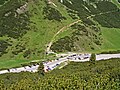
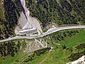
Steep ascent of the Imst pass road

View from the top of the pass to the east
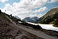
View from the top of the pass to the west

Maldonalm on the Hahntennjoch
Hahntennjoch pass summit
Hahntennjoch pass from the summit of the Falschen Kogel ( 2388 m )


Web links
Individual evidence
- ↑ Surroundings of the Hahntennjoch on ÖK 50 , www.austrianmap.at , Federal Office for Metrology and Surveying Austria, Austrian map.
- ↑ Village chronicle of the municipality of Pfafflar. ( Memento of the original from January 17, 2017 in the Internet Archive ) Info: The archive link was inserted automatically and has not yet been checked. Please check the original and archive link according to the instructions and then remove this notice.
Ahorn • Alpl • Ammer • Annaberg • Arlberg • Ascher • Bieler • Birkfelder • Boding • Brenner • Buchauer • Buchener • Dientner • Dürrholzer • Eibegg • Erb • Eisental • Faschina • Feistritz • Fern • Filzen • Flattnitz • Flexen • Forsthof • Furka • Fuscher • Gaberl • Gaden wide • Gailberg • Gangleit • Geiseben • Gerichtsberg • Gerlos • Geschriebenstein • Goller • Grießen • Griffner • Large Kripp • Grubberg • Grünbacher • Gschuett • Hafner • Hahntenn • neck • Haselrast • Hebalm • stallion • Hengstl • Hiaslegg • Hirschegger • Hochegger • Hochrindl • Hochtannberg • Hochtor • Holzleiten • Iselsberg • Josefsberg • Kaiserauer • Cold Kuchl • Kartitscher • Katsch • Kernhofer • Kerschbaumer • Klachauer • Klamm • Klamml • Small Kripp • Klippitz • Klostertaler • Kraxen • Kreuth • Kreuzberg • Kühtai • Lahn • Lienbach • Loibl • Losen • Luft • Mendling • Michelbühel • Moarigraben • Nassfeld • Neumarkter • Niederalpl • Norberts • Nöring • Obdacher • Oberjoch • Och • Pack • Paulitsch • Perchauer • Pfaffen • Pfarralm • Pielachtaler • Piller • Plöcken • Pogusch • Pölshals • Pötschen • Präbichl • Prebersattel • Preiner • Pretal • Promau • Pyhrn • Radl • Radling • Radstädter • Radstatt • Rams • Raneck • Rechberg • Rieder • Rohrer • Sattler • Saurüssel • Schaida • Schanz • Scharflinger • Schiestel • Schober • Schönfeld • Schwarze Sau • Schwarzenbichl • Seeberg • Seefelder • Semmering • Kleiner Semmering • Sieggraben • Silzer • Soboth • Summer • Staller • Styrian Seeberg • Straßegg • Sölk • Thurn • Timmels • Triebener Tauern • Turracher • Origin • Wechsel • Weinebene • Weißenbacher • Wagrainer • Windische • Wurzen • Zellerrain