
Reutte district
| location | |
|---|---|
  |
|
| Basic data | |
| state | Tyrol |
| NUTS III region | AT-331 |
| Administrative headquarters | Reutte |
| surface | 1236 km² |
| Residents | 32,838 (January 1, 2020) |
| Population density | 27 inhabitants / km² |
| License Plate | RE |
| District Commission | |
| District chief | Mag. Katharina Rumpf |
| website |
www.tirol.gv.at/ bezirke / reutte |
| map | |
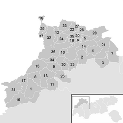  |
|
The Reutte district is a political district of the Austrian state of Tyrol , it is congruent with the Ausserfern region .
It borders:
- on the north by Bavaria ( Oberallgäu , Ostallgäu and Garmisch-Partenkirchen )
- in the south to the districts of Landeck and Imst and
- in the west to Vorarlberg (districts Bregenz and Bludenz ).
geography
The district covers 1,235.67 km², these extend over the Lech Valley , the Tannheim Valley and the so-called intermediate gates between Reutte and the Fernpass . In terms of mountains, the district has a share of the Lechtal Alps , Wetterstein Mountains , Allgäu Alps (including Tannheimer Mountains ) and the Ammergau Alps .
Important lakes are the Plansee , Heiterwanger See , Haldensee , Urisee and Vilsalpsee .

The upper Lechtal from the mountain station of the Lechtaler Bergbahn

Lechtal Alps


history
About the origin of the word "Ausserfern"
Presumably the name derives from "Besides the Fern" ( Fernpass ). Outside and inside are frequent descriptive additions to a valley in Tyrolean and differentiate between the valley entrance and the rear valley areas, or between the valley section from the main town of the valley downstream and the areas uphill, or simply the directions in and out of the valley. “Ausserfern” may refer to the valley up to the historic ascent to the Fernpass.
Regional history
The area was settled by Alamannen along the Via Claudia Augusta from the 10th century and came to the County of Tyrol at the end of the 13th century by Duke Meinhard as part of the territorialization of the Holy Roman Empire , although there are close economic and cultural ties to the Allgäu region stayed. For a long time, the Ausserfern was ecclesiastically subordinate to the diocese of Augsburg , which had already been given important sovereign rights here by King Heinrich IV with the wild ban in 1059 . The cheaper transport connections to the Allgäu and Upper Bavaria also contributed to this orientation , while there was only one winter-safe connection to the Inn Valley , namely the Fernpass.
Population development

Economy and Infrastructure

The tourism is an important source of income, because of the rather barren and high-lying ground is hard to manage, but there is a certain amount of dairy farming . In addition, industry and commerce play a role , especially in the central Lech Valley and the Reutten Basin .
The district forms a closed labor market and has a comparatively low proportion of outbound and inbound commuters from other regions.
In the field of services, tourism dominates, especially in the Zugspitze, Tannheimer Tal, Plansee, Lechtal and side valleys areas. Larger industrial centers are Reutte, Elbigenalp, Höfen and Vils, important production companies can be found in the metal and construction industries.
The Tiroler Zugspitz Arena, with the Ehrwalder Alm ski areas in Ehrwald and Grubigstein in Lermoos, as well as the Bichlbach / Berwang ski area, provides the basis for tourism in the Ausserfern region. With over 800,000 overnight stays in the 2017/18 winter season, it is one of the top 20 winter tourism regions in Tyrol. There is also significant tourism in the Tannheimer Tal. The Tiroler Lech Nature Park with the Lech as one of the last natural rivers in Europe, combined with the multitude of sporting opportunities, is also of touristic importance.
traffic
The main connection to the rest of Tyrol is the Fernpass . The B179 Fernpassstraße leads through the Ausserfern from the Fernpass to the German border at Vils. The B179 is an important transit and holiday route. Miles of traffic jams are not uncommon, especially on holiday weekends. The tendency to expand this traffic problem beyond the holiday weekends can be clearly seen in recent years. Via the Lechtalstraße B198 you can get from Reutte through the Lech Valley to Vorarlberg.
On the Ausserfernbahn , the area can be reached by rail from Garmisch-Partenkirchen or Kempten (Allgäu) .
Culture
Linguistic peculiarity
In linguistic terms, there is a mixed form of Swabian or Alemannic and Bavarian , whereby the spoken dialect often differs from valley to valley and from place to place. The areas populated from Upper Bavaria and the Inn Valley , such as the Ehrwalder Basin and the side valleys of the Lech Valley , are linguistically similar to the dialects of the Upper Inn Valley , while a Swabian-Alemannic dialect dominates in the area around Reutte , in Vils and in the Tannheim Valley and in the upper Lechtal Most Alemannic dialects are spoken around Steeg , which was settled from Vorarlberg over the Arlberg Pass .
Sports
Due to the geographical conditions, winter sports in the Ausserfern region have always played a major role. The district is home to some ski racers such as Nicole Hosp , Harti Weirather , Josef Pechtl , Walter Schuster and Josef Rieder .
In the district capital Reutte, SV Reutte is the largest sports club in the district with its 17 branches. The club is best known for its football department, which at times played in the fourth-class Tyrolean league, as well as the successful athletics department.
Administrative organization and spatial planning

Community structure
The Reutte district is divided into 37 communities , including the town of Vils and the market town of Reutte . The population figures are from January 1st, 2020.
NUTS classification: AT331
In the official statistics of the EU led NUTS headings from is Außerfern one of the five groups of districts (level NUTS: AT -2) in Tyrol, carries the code AT331and includes the political district of Reutte.
Regional planning
Today the term is used in particular as the regional development Ausserfern - the region is part of the European regions Tyrol-South Tyrol-Trentino , EUREGIO Via Salina and Zugspitze-Wetterstein-Karwendel .
List of municipalities in the district
- Regions are Tyrolean planning associations (as of March 2017)
| local community | location | Ew | km² | Ew / km² | Judicial district | region | Type
|
photo | Metadata |
|---|---|---|---|---|---|---|---|---|---|
Brook
|

|
623 | 56.86 | 11 | Reutte | Upper Lechtal | local community
|

|
According to code: 70801 |
Berwang
|

|
586 | 42.69 | 14th | Reutte | Intermediate gates | local community
|

|
Acc. To code: 70802 |
Biberwier
|

|
622 | 29.39 | 21st | Reutte | Intermediate gates | local community
|

|
According to code: 70803 |
Bichlbach
|

|
788 | 30.62 | 26th | Reutte | Intermediate gates | local community
|

|
Acc. To code: 70804 |
Breitenwang
|

|
1,456 | 18.94 | 77 | Reutte | Reutte and the surrounding area | local community
|

|
Acc. To code: 70805 |
Ehenbichl
|

|
821 | 7.31 | 112 | Reutte | Reutte and the surrounding area | local community
|

|
Acc. To code: 70806 |
Ehrwald
|

|
2,610 | 49.32 | 53 | Reutte | Intermediate gates | local community
|
|
According to code: 70807 |
Elbigenalp
|

|
887 | 33.08 | 27 | Reutte | Upper Lechtal | local community
|

|
Acc. To code: 70808 |
Elmen
|

|
383 | 29.6 | 13 | Reutte | Upper Lechtal | local community
|

|
Acc. To code: 70809 |
Forchach
|

|
263 | 14.24 | 18th | Reutte | Upper Lechtal | local community
|

|
Acc. To code: 70810 |
Grän
|

|
592 | 20.9 | 28 | Reutte | Tannheim Valley | local community
|

|
According to code: 70811 |
Gramais
|

|
41 | 32.43 | 1.3 | Reutte | Upper Lechtal | local community
|

|
Acc. To code: 70812 |
Häselgehr
|

|
676 | 50.52 | 13 | Reutte | Upper Lechtal | local community
|

|
Acc. To code: 70813 |
Cheerfulness
|

|
533 | 35.7 | 15th | Reutte | Intermediate gates | local community
|

|
Acc. To code: 70814 |
Hinterhornbach
|

|
91 | 50.55 | 1.8 | Reutte | Upper Lechtal | local community
|

|
According to code: 70815 |
Yards
|

|
1,210 | 8.37 | 145 | Reutte | Reutte and the surrounding area | local community
|

|
According to code: 70816 |
Holzgau
|

|
401 | 35.98 | 11 | Reutte | Upper Lechtal | local community
|

|
According to code: 70817 |
Young wood
|

|
308 | 7.05 | 44 | Reutte | Tannheim Valley | local community
|

|
Acc. To code: 70818 |
Emperor
|

|
75 | 74.43 | 1 | Reutte | Upper Lechtal | local community
|

|
Acc. To code: 70819 |
Lechaschau
|

|
2,094 | 6.11 | 343 | Reutte | Reutte and the surrounding area | local community
|
.jpg)
|
Acc. To code: 70820 |
Lermoos
|

|
1,143 | 56.41 | 20th | Reutte | Intermediate gates | local community
|

|
According to code: 70821 |
Musau
|

|
390 | 20.66 | 19th | Reutte | Reutte and the surrounding area | local community
|

|
Acc. To code: 70822 |
Nameless
|

|
73 | 28.75 | 2.5 | Reutte | Upper Lechtal | local community
|

|
Acc. To code: 70823 |
Nesselwängle
|

|
462 | 23 | 20th | Reutte | Tannheim Valley | local community
|

|
According to code: 70824 |
Pfafflar
|

|
105 | 33.59 | 3.1 | Reutte | Upper Lechtal | local community
|

|
According to code: 70825 |
Pflach
|

|
1,446 | 13.77 | 105 | Reutte | Reutte and the surrounding area | local community
|
.jpg)
|
Acc. To code: 70826 |
Pinswang
|

|
405 | 9.37 | 43 | Reutte | Reutte and the surrounding area | local community
|
|
According to code: 70827 |
Reutte
|

|
6,918 | 100.78 | 69 | Reutte | Reutte and the surrounding area | market community
|

|
Acc. To code: 70828 |
Schattwald
|

|
450 | 16.15 | 28 | Reutte | Tannheim Valley | local community
|

|
Acc. To code: 70829 |
Stanzach
|

|
462 | 31.73 | 15th | Reutte | Upper Lechtal | local community
|

|
According to code: 70830 |
Steeg
|

|
662 | 67.95 | 9.7 | Reutte | Upper Lechtal | local community
|

|
Acc. To code: 70831 |
Tannheim
|

|
1.105 | 51.28 | 22nd | Reutte | Tannheim Valley | local community
|

|
Acc. To code: 70832 |
Vils
|

|
1,492 | 30.77 | 48 | Reutte | Reutte and the surrounding area | urban community
|

|
Acc. To code: 70833 |
Vorderhornbach
|

|
250 | 17.23 | 15th | Reutte | Upper Lechtal | local community
|

|
Acc. To code: 70834 |
Wangle
|

|
930 | 9.33 | 100 | Reutte | Reutte and the surrounding area | local community
|

|
Acc. To code: 70835 |
Weißenbach am Lech
|

|
1,252 | 82.01 | 15th | Reutte | Reutte and the surrounding area | local community
|

|
Acc. To code: 70836 |
Zöblen
|

|
233 | 8.78 | 27 | Reutte | Tannheim Valley | local community
|

|
Acc. To code: 70837 |
literature
- F. Fuchs: Heimat Ausserfern - A local history of the Reutte district. Exceptferner Druck- und Verlagsgesellschaft, Reutte 1984, ISBN 3-9002-8101-7 .
- H. Gasser: The Ausserfern experience. Leopold Stocker Verlag, Graz / u. a. 1978, ISBN 3-7020-0319-3 .
- Catholic Tyrolean Teachers' Association & District School Council Reutte: The Reutte District - The Ausserfern. Koch, Höfen 2004, ISBN 3-7081-0005-0 .
- L. Lechenbauer: Ausserfern - A gem in Tyrol. Theiss, Wolfsberg 1973.
- R. Lipp: Ausserfern. Tyrolia, Innsbruck / u. a. 1994, ISBN 3-7022-1927-7 .
- Science and economy
- F. Greif, W. Schwackhöfer: The social wasteland in the high mountains using the example of the Ausserfern. (= Series of publications by the Agricultural Institute of the Federal Ministry of Agriculture and Forestry. 31). Österreichischer Agrarverlag, Vienna 1979.
- H. Koller: The electricity industry of the Ausserfern. (= Contributions to Alpine economic and social research. 57). Wagner, Innsbruck 1969, DNB 365120472 .
- R. v. Klebelsberg: Ausserferner geology. In: Schlern writings. 111, Innsbruck 1955, pp. 9-23.
- G. Mutschlechner: The ore mining in Ausserfern. In: Schlern writings. 111, Innsbruck 1955, pp. 25-52.
- R. Schöner, H. Scholz, H. Krumm: The medieval iron production in the Füssener Land (Ostallgäu and Ausserfern) - New results for the mining and smelting of iron ores from the Wetterstein limestone. In: Arch. F. Storage research Geol. B.-A. 24, Vienna 2003, pp. 193-218.
- H. Thurner: The long-distance railway, a new north-south line Germany-Italy - a contribution to the people's welfare of West Tyrol's lifeblood. Self-published by Thurner, Innsbruck 1924.
- Franz Gemeinböck, Markus Inderst: Mittenwaldbahn. Innsbruck - Garmisch-Partenkirchen - Reutte. Kiruba-Verlag, Mittelstetten 2012, ISBN 978-3-9812977-5-1 .
- History, culture
- WA Ruepp: Ausserferner peculiarity. A human search for clues. Ehrenberg-Verlag, Reutte 2004, ISBN 3-901821-08-2 .
- Oswald Trapp : Oberinntal and Ausserfern. (= Tyrolean Castle Book. VII). Athesia, Bozen 1986, ISBN 88-7014-391-0 .
- Periodicals
- Except for remote news . Reutte.
- Series Ausserferner Schriften , RTW Verlag, Reutte.
See also
Web links
- Association for regional development Ausserfern of the 37 municipalities in the district
- District authority Reutte
- Wolfgang Ruepp on the Ausserferner Eigenart (selected chapters of the book)
- History of the Reutte district
Individual evidence
- ^ Karl Finsterwalder : The place names in Ausserfern. In: H. M. Ölberg, N. Grass: Tyrolean toponymy - collected essays and works. Volume 3, Wagner, Innsbruck 1995, pp. 1197-1210.
- ↑ Martin Bitschnau , Hannes Obermair : Tiroler Urkundenbuch, II. Department: The documents on the history of the Inn, Eisack and Pustertal valleys. Volume 1: By the year 1140 . Universitätsverlag Wagner, Innsbruck 2009, ISBN 978-3-7030-0469-8 , p. 206, no. 228 .
- ↑ TOURISM IN WINTER 2017/2018. Retrieved April 19, 2019 .
- ↑ Statistics Austria - Population at the beginning of 2002–2020 by municipalities (area status 01/01/2020)
NUTS: AT-1 group of federal states : AT1 Eastern Austria • AT2 Southern Austria • AT3 Western Austria
NUTS: AT-2 federal states : AT11 Burgenland • AT12 Lower Austria • AT13 Vienna • AT21 Carinthia • AT22 Styria • AT31 Upper Austria • AT32 Province of Salzburg • AT33 Tyrol • AT34 Vorarlberg
NUTS: AT-3 group of districts : AT111 Mittelburgenland • AT112 Northern Burgenland • AT113 Southern Burgenland • AT121 Mostviertel-Eisenwurzen • AT122 Lower Austria-South • AT123 St. Pölten • AT124 Waldviertel • AT125 Weinviertel • AT126 Vienna region / northern part • AT127 Vienna region / southern part • AT130 Vienna • AT211 Klagenfurt-Villach • AT212 Upper Carinthia • AT213 Lower Carinthia • AT221 Graz • AT222 Liezen • AT223 Eastern Upper Styria • AT224 Eastern Styria • AT225 Western and Southern Styria • AT226 Western Upper Styria • AT311 Innviertel • AT312 AT314 Mühlviertel • AT312 Linz-Wels Steyr-Kirchdorf • AT315 Traunviertel • AT321 Lungau • AT322 Pinzgau-Pongau • AT323 Salzburg and surroundings • AT331 Ausserfern • AT332 Innsbruck • AT333 East Tyrol • AT334 Tiroler Oberland • AT335 Tiroler Unterland • AT341 Bludenz-Bregenz Forest • AT342 Rheintal-Bodensee region
LAU: AT-1 not occupied
Coordinates: 47 ° 29 ' N , 10 ° 43' E