Haldensee
| Haldensee | ||
|---|---|---|

|
||
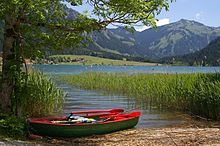
| View from the Roten Flüh to the Haldensee and Tannheimer Tal | ||
| Geographical location | Allgäu Alps | |
| Tributaries | Gessenbach, Strindenbach | |
| Drain | Berger Ache | |
| Places on the shore | Haldensee, Haller | |
| Data | ||
| Coordinates | 47 ° 29 '29 " N , 10 ° 34' 37" E | |
|
|
||
| Altitude above sea level | 1124 m above sea level A. | |
| surface | 73 ha | |
| length | 1.4 km | |
| width | 800 m | |
| volume | 10,407,415 m³ | |
| scope | 3.8 km | |
| Maximum depth | 22 m | |
| Middle deep | 14 m | |
| Catchment area | 12 km² | |
The Haldensee is 1124 m above sea level. A. high altitude, 73 hectare lake in the Tannheimer Tal between Grän and Nesselwängle in the Austrian state of Tyrol .
geography
The Haldensee lies around 1 km west of the valley watershed between Vils and Lech and takes up the entire width of the valley floor. Accordingly, the banks in the north and south are steep, while they are relatively flat in the east and west. The outflow is the Berger Ache to the Vils in the west, the main tributaries are the Gessenbach in the southeast and the Strindenbach in the southwest. Near the west bank is the village of the same name Haldensee (municipality of Grän), at the northeastern end the village of Haller, part of the municipality of Nesselwängle. Tannheimer Straße (B 199) runs along the north bank .
Hydrology
The natural catchment area of the Haldensee is 12 km². It mainly consists of forests and near-natural areas (89.5%). 3.7% are used for agriculture and 6.8% are water bodies. The mean discharge is 0.46 m³ / s, the (theoretical) water renewal time 0.7 years. The average water temperature in January is 1.2 ° C, in July 18.5 ° C, it can rise to 26 ° C in summer. The lake is regularly frozen from January to March.
ecology
The Haldensee is a nutrient-poor body of water in a stable oligotrophic ground state. The average depth of view is 4.6 m (1992–2009). The overall ecological condition is rated as very good, the bathing water quality was rated as excellent in 2014.
The shallow bank zones are covered with aquatic plants such as candelabrum algae , spawning herbs or pine fronds . A silting zone with a belt of reeds has formed in the southeast around the mouth of the Gessenbach .
The fish species found in the Haldensee include aitel , perch , pike , carp , whitefish , roach and tench . On the south bank of the Haldensee there is one of only two stone crayfish occurrences in Tyrol, which may not be of natural origin, but rather due to an artificial population. In particular, the reed belt in the southeast serves as a staging and wintering ground for waterfowl such as Bless Rail , little grebe and great crested grebes . The species mentioned, as well as mallards , goosander and black-necked grebes, are also known to breed.
use
The lake is a popular destination for recreation and leisure activities and is used for swimming and fishing, among other things. There is a hotel and a lido with a campsite on its banks. While the lake is icy in the winter months, it can be crossed in a west-east direction on a marked and groomed path on foot or on skis.

Web links
Individual evidence
- ↑ a b c d e f g h Federal Office for Water Management (Hrsg.): Atlas of the natural lakes of Austria with an area ≥ 50 ha. Morphometry - typing - trophy. As of 2005. Series of publications by the Federal Office for Water Management, Volume 29, Vienna 2008, pp. 127–129 ( PDF; 9 MB )
- ↑ a b c State survey service: Haldensee depth map (PDF; 1.3 MB)
- ↑ a b Federal Ministry of Health and Office of the Tyrolean Provincial Government (ed.): Bathing water profile Haldensee, lido. Vienna 2015 ( PDF; 1.2 MB )
- ↑ Office of the Tyrolean Provincial Government (Ed.): Statistisches Handbuch Bundesland Tirol 2014 , p. 22 ( PDF; 13.1 MB )
- ↑ a b c Armin Landmann: On the importance of the waters of North Tyrol as resting and wintering places for water birds (Gaviidae, Podicipedidae, Anatidae, Rallidae and Laridae). Results of the water bird censuses from 1969/70 to 1980/81. In: Egretta - Vogelkundliche Nachrichten aus Österreich 24/1 (1981), pp. 1–40 ( PDF; 2.7 MB )
- ↑ a b Yoichi Machino, Leopold Füreder: The stone crayfish Austropotamobius torrentium (SCHRANK, 1803) in Haldensee (Tyrol, Austria) and further evidence of crayfish in high water. In: Reports of the Natural Science and Medical Association in Innsbruck, Volume 85 (1998), pp. 223–229 ( PDF; 2.3 MB )
- ↑ Federal Office for Water Management, Institute for Aquatic Ecology, Fishery Biology and Seology (Ed.): The fish species communities of the great Austrian lakes. Comparison between historical and current situation. Fish ecological lake types. Publication series of the Federal Office for Water Management, Volume 18, Vienna 2003, p. 101 ( PDF; 2.8 MB ( Memento of the original from December 20, 2015 in the Internet Archive ) Info: The archive link was inserted automatically and has not yet been checked. Please check the original - and archive link according to the instructions and then remove this note. )
- ↑ Leopold Füreder, Yoichi Machino: Historical and recent spread of crayfish in Tyrol, South Tyrol and Vorarlberg. In: Stapfia. Volume 58, Linz 1998, pp. 77-88, PDF (1.2 MB) on ZOBODAT

