Badsee (Isny)
| Badsee or Haldensee | ||
|---|---|---|

|
||
| Geographical location | Ravensburg district , Baden-Württemberg , Germany | |
| Tributaries | Rötelbach et al | |
| Drain | Tobelbach → Lower Argen | |
| Location close to the shore | Isny in the Allgäu | |
| Data | ||
| Coordinates | 47 ° 45 '2 " N , 9 ° 59' 59" E | |
|
|
||
| Altitude above sea level | 680 m above sea level NHN | |
| surface | 42.5 ha | |
| length | 1.2 km | |
| width | 450 m | |
| volume | 1,614,000 m³ | |
| Maximum depth | 7.2 m | |
| Middle deep | 3.8 m | |
| Catchment area | 5.42 km² | |
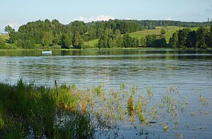
The Badsee (also Haldensee ) is a 42.5 hectare lake in the area of the city of Isny im Allgäu and the municipality of Argenbühl in the Baden-Württemberg district of Ravensburg . From the northwest shore of his silting range finds date from the early Mesolithic period (Mesolithic).
location
The lake is at an altitude of 680 m above sea level. NHN , around seven kilometers northwest of Isny, between the towns of Allmisried in the north and east, Beuren in the south and Enkenhofen in the south-west. It was formed at the end of the last ice age around 16,000 years ago.
Hydrology
The Badsee has a catchment area of around 542 ha. With a size of 42.5 ha (approx. 1,200 m × 450 m) and an average depth of 3.8 meters (max. Depth = 7.2 m), the lake volume is 1,614 .000 cubic meters.
It is fed, among other things, by the Rötelbach , which flows into the east and leaves the lake as Tobelbach (also called Badseebach) over the Untere Argen to Lake Constance in the Rhine . Since the Badsee lies on the European main watershed , the Taufach-Fetzachmoos bordering it is drained to the Danube .
ecology
| year | 1987 | 1996 | 2004 |
| Total PO 4 - phosphorus (µg / l) | 117 | 85 | 96 |
| Chlorophyll a (µg / l) | 18th | 39 | 35 |
| Chlorophyll a - peak (µg / l) | 40 | 92 | 85 |
| Total inorganic nitrogen (mg / l) | 0.45 | 0.27 | 0.36 |
| Viewing depth (m) | 0.6 | 1.0 | 1.3 |
With the help of the action program for the rehabilitation of Upper Swabian lakes , various extensification measures have been carried out since the 1990s .
Protected areas
The south-western area of the lake is part of the Badsee nature reserve ; surrounded the entire lake from the conservation area Badsee .
Others
The town of Isny operates a natural swimming pool at Badsee in summer and an approximately five-kilometer cross-country ski run around the lake in the winter months . There is a campsite on the north bank in the Allmisried district.
Web links
literature
- Hans Reinerth: The oldest settlement in the Allgäu. Prehistoric times on Lake Constance . Announcements on the prehistory and early history and local history of the Lake Constance area 1- 4, 1956, 1-37

