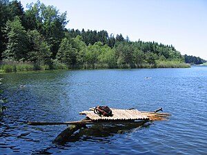
Degersee
| Degersee | |
|---|---|

|
|
| View from the south bank of the Degersee | |
| Geographical location |
Germany , BW / Bodenseekreis and BY / District Lindau (Bodensee) |
| Drain | via Nonnenbach into Lake Constance ( Rhine ) |
| Places on the shore |
Tettnang districts Busenhaus and Degersee |
| Location close to the shore | Tettnang and Lindau |
| Data | |
| Coordinates | 47 ° 36 '45 " N , 9 ° 39' 0" E |
| Altitude above sea level | 478.2 m |
| surface | 30.2 ha |
| volume | 1,828,000 m³ |
| Maximum depth | 11.3 m |
| Middle deep | 6.1 m |
| Catchment area | 1.36 km² |
|
particularities |
|

|
|
| View from the south-east bank of the Degersee | |
The Degersee is a small swimming lake a few kilometers north of the shores of Lake Constance in Baden-Württemberg . It is partially surrounded by forest, relatively warm in summer, often freezes over completely in winter, and has two public baths. In addition to bathing, the lake is also used as a fishing spot.
location and size
The Degersee largely belongs to the area of the city of Tettnang in the Lake Constance district . A small area in the southeast belongs to the Bavarian city of Lindau . The lake is located in the hilly hinterland of Lake Constance , which is often characterized by fruit growing , at an altitude of 478.2 m above sea level. NHN . The size of the lake is 30 hectares , its shore length about 2730 meters. With an average depth of around six meters and a maximum depth of eleven meters, the lake has a volume of around 1.828 million cubic meters .
Emergence
Like the nearby Schlein , Wieland and Muttelsee lakes , the Degersee emerged as a meltwater lake towards the end of the last Ice Age. The above-ground tributaries are insignificant, the water exchange takes place mainly through an intensive groundwater flow. The Degersee drains into Lake Constance via the pond at Hörbolzmühle and the Nonnenbach and is thus part of the Rhine river system .
biology
The Degersee is located in a landscape conservation area , the surrounding agricultural areas (90 percent grassland, 7% special crops, 3% arable land) are mainly used for livestock farming, which, combined with the slope of the usable areas, leads to a considerable input of nutrients . Extensification measures, which are already having an effect on Schleinsee, are also intended to reduce the degree of eutrophication in Degersee. Both lakes are part of the action program for the rehabilitation of Upper Swabian lakes .
| year | 1986 | 1994 | 1995 | 1997 | 2007 |
| Total PO 4 - phosphorus (µg / l) | 34 | 28 | 20th | 43 | 45 |
| Chlorophyll a (µg / l) | 13 | 5.1 | 7.4 | ||
| Chlorophyll a peak (µg / l) | 29 | 13 | 13 | ||
| anorg. Total nitrogen (mg / l) | 0.71 | 0.63 | 0.72 | 0.64 | 0.58 |
| Viewing depth (m) | 2.2 | 3.0 | 2.8 | 1.8 |
| year | 1994 | 1995 | 2007 |
| o-PO 4 -phosphorus (µg / l) | 98 | 171 | 114 |
| Total PO 4 phosphorus (µg / l) | 179 | 477 | 245 |
| Nitrate nitrogen (mg / l) | 5.25 | 7.02 | 5.22 |
| total inorganic nitrogen (mg / l) | 5.60 | 7.38 | 5.38 |
| Water flow (l / s) | 2.9 | 12.6 | 37.0 |
flora
The white water lily ( Nymphaea alba ), which is a typical representative of floating leaf plants, the yellow pond rose ( Nuphar lutea ) and the swamp iris ( Iris pseudacorus ), also known as the yellow iris , are found in the protected area of Degersee .
fauna
The Degersee is stocked with pikeperch , pike , catfish , eel and carp ; In addition, roach , bream , perch , tench , crucian carp and bleak are found in the lake.
Numerous species of dragonflies and birds can be observed in the bank area .
Neolithic settlement
Archaeological explorations have shown a complete village for 150-200 people in Degersee, which is now about three meters below the lake floor. Numerous artifacts have been found, including axes cut from hard stone and a six-meter-long dugout canoe . Numerous flint tools from the Lake Garda region show trade connections to Northern Italy . A chance find in 2002 brought archaeologists on the trail of the village.
Web links
- Action program for the rehabilitation of Upper Swabian lakes
- Article in the “Südkurier” on the archaeological exploration of the Degersee
Individual evidence
- ^ State Office for the Preservation of Monuments in the Stuttgart Regional Council (editor), Martin Mainberger (author), Josef Merkt (author), Angelika Kleinmann (author): Pfahlbausiedlungen am Degersee: Archaeological and scientific research. - Reports on river bank and bog settlements in southwest Germany; January 2016; Konrad Theiss publishing house, ISBN 978-3-8062-2970-7 .
- ↑ The Degersee at Unterwasserarchäologie (UWARC) , accessed on May 16, 2017
