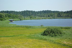
Great Ursee
| Great Ursee | ||
|---|---|---|

|
||
| The "Great Ursee" | ||
| Geographical location | Ravensburg district , Baden-Württemberg , Germany | |
| Tributaries | Drainage ditches, drainage of the "Kleiner Ursee" and "Gießbächle" | |
| Drain | Fetzachgraben → Eschach → Aitrach → Iller → Danube → Black Sea | |
| Places on the shore | Beuren | |
| Location close to the shore | Isny in the Allgäu | |
| Data | ||
| Coordinates | 47 ° 45 '8 " N , 10 ° 1' 27" E | |
|
|
||
| Altitude above sea level | 694.9 m above sea level NHN | |
| surface | 19.4 ha | |
| volume | 859,000 m³ | |
| Maximum depth | 9.8 m | |
| Middle deep | 4.4 m | |
| Catchment area | 2.08 km² | |
|
particularities |
Action program for the rehabilitation of Upper Swabian lakes |
|
The Great Ursee is 19.4 hectares large pond near the town Isny in Baden-Württemberg district Ravensburg .
Emergence
The lake, like the Kleine Ursee further to the north , was created in a former dead ice hole on the inner edge of the outer young moraine .
location
It lies at an altitude of 694.9 m above sea level. NHN , around six and a half kilometers north of Isny and northeast of the Beuren district .
To the east of the two lakes is the moor and nature reserve " Taufach-Fetzachmoos ", a very varied area with numerous rare animal and plant species. The originally strong height differences in the terrain were leveled out by the growing bog.
Hydrology
The catchment area of the privately owned Great Ursee has a size of around 208 hectares (ha). With a size of 19.4 ha, an average depth of 4.4 meters and a maximum depth of 9.8 m, the volume of the lake is around 859,000 cubic meters.
The Große Ursee is fed by the course of the Kleiner Ursee, the Gießbächle coming from Beuren and around 20 drainage ditches in the west and south.
The process takes place over the Fetzachgraben , the Eschach , the Aitrach and the Iller into the Danube and thus into the Black Sea .
ecology
Since 2000, Leutkirch im Allgäu (catchment area only) and Isny have been involved in the action program for the rehabilitation of Upper Swabian lakes with the “Großer Ursee” . An important goal of this program is to reduce nutrient inputs into streams , lakes and ponds and thereby improve and maintain the condition of the water bodies.
15 percent of the lake's catchment area is used for forest and 70 percent for agriculture - 100% of which is grassland.
| year | 2000 | 2001 | 2008 | 2013 |
| Total PO 4 - phosphorus (µg / l) | 93 | 75 | 78 | 56 |
| Chlorophyll a (µg / l) | 39 | 40 | 63 | 20th |
| Chlorophyll a peak (µg / l) | 70 | 61 | 105 | 41 |
| Total inorganic nitrogen a (mg / l) | 0.47 | - | 0.49 | 0.29 |
| Viewing depth (m) | 0.7 | 0.6 | 0.6 | 1.0 |
Web links
Individual evidence
- ↑ Top25 Viewer - [Top. Map 1: 25000 Baden-Württemberg (South)]

