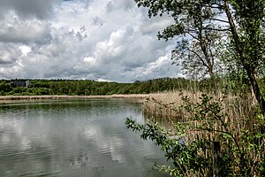
Zeller See (Bad Schussenried)
| Lake Zell | |
|---|---|

|
|
| Geographical location | Bad Schussenried , Biberach District , Baden-Württemberg ( Germany ) |
| Tributaries | Zellerseegraben, ... |
| Drain | Zellerseegraben → Schussen → Rhine → North Sea
Zellersee drainage ditch → (Altarm Schussen) → Schussen → ... |
| Data | |
| Coordinates | 48 ° 0 '7 " N , 9 ° 38' 42" E |
| Altitude above sea level | 577 m above sea level NHN |
| surface | 3.376 2 ha |
| length | 350 m |
| width | 185 m |
| volume | 61,000 m³ |
| Maximum depth | 3.6 m |
| Middle deep | 1.8 m |
| Catchment area | 1.2 km² |
|
particularities |
|
The Zeller Lake is a 3.4 hectare large pond near the town Bad Schussenried in Baden-Württemberg district Biberach ( Germany ).
geography
location
Lake Zell is located about 1000 meters southwest of the center of the city of Schussenried and 250 meters east below the Schussenried hamlet of Zeller Hof at an altitude of 577 m above sea level. NHN .
Inflow and outflow
The Zellerseegraben flows from the southwest Coming into the lake and drained it to the northeast to Schussen , which is also the outgoing at the southeast end of the lake and apparently mostly verdolt current Zellerseeablaufgraben achieved through a bayou from her; this then leads the runoff to Lake Constance , thus the Rhine and ultimately the North Sea .
history
Lake Zell was created in a dead ice hole . After his extensive siltation he was dammed and is therefore now a ablassbarer pond . Since 2008 the water level of the lake has been regulated by a monk . Today the lake is owned by the state of Baden-Württemberg, which leased it to a local fishing club .
Sea data and hydrology
The water surface of the Zeller See is 3.4 hectares . The lake is 350 meters long and 185 meters wide, and its banks are around 900 meters long. It is a maximum of 3.6 m deep, with an average depth of 1.8 m results in a volume of around 61,000 cubic meters .
The catchment area of the lake - 35 percent is used by forest, 50% by agriculture, of which 46% is green and 54% is arable land - covers 120 hectares.
ecology
Since 2000 Bad Schussenried has been involved in the action program for the rehabilitation of Upper Swabian lakes with Lake Zell . An important goal of this program is to reduce nutrient inputs in streams, lakes and ponds and thereby improve and maintain the condition of the water bodies.
| year | 2000 | 2003 | 2009 |
| Total PO 4 - phosphorus (µg / l) | 21st | 49 | 43 |
| Chlorophyll a (µg / l) | 17th | 7th | 19th |
| Chlorophyll a peak (µg / l) | 29 | 15th | 45 |
| total inorganic nitrogen a (mg / l) | - | 0.96 | 0.81 |
literature
- Topographic map 1: 25,000, Baden-Württemberg, as single sheet No. 7923 Saulgau Ost and - only for the catchment area - No. 8023 Aulendorf
Web links
- Action program for the rehabilitation of Upper Swabian lakes
- Map of Lake Zell and the surrounding area on: State Agency for the Environment Baden-Württemberg (LUBW) ( Notes )
- Map of Lake Zell and the surrounding area on: Geoportal Baden-Württemberg ( information )
Individual evidence
L - LUBW :
Official online waterway map with a suitable section and the layers used here: Lake Zell and the surrounding area
General introduction without default settings and layers: State Institute for the Environment Baden-Württemberg (LUBW) ( notes )
- ↑ a b c Lake area according to the layer standing waters .
- ↑ a b c d Dimensions measured on the background layer topographic map .
Other evidence:
- ↑ a b Height according to the blue lettering on a section map of Lake Zell and the surrounding area ( memento of the original from February 11, 2016 in the Internet Archive ) Info: The archive link was inserted automatically and has not yet been checked. Please check the original and archive link according to the instructions and then remove this notice. (Layer DTK 10) at: Geoportal Baden-Württemberg ( information )

