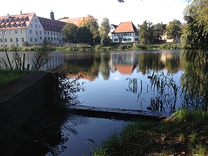
Klosterweiher (forest)
| Monastery pond | ||
|---|---|---|

|
||
| The monastery pond, in front the overflow of the Burraubach on the southeast bank, in the background the monastery and rectory. | ||
| Geographical location | Forest , Sigmaringen district , Baden-Württemberg , Germany | |
| Tributaries | Burraubach | |
| Drain | Burraubach → Kehlbach → Andelsbach → Ablach → Danube → Black Sea | |
| Data | ||
| Coordinates | 47 ° 56 '13.9 " N , 9 ° 10' 28.9" E | |
|
|
||
| Altitude above sea level | 655 m above sea level NHN | |
| surface | 1 ha | |
| volume | 26,700 m³ | |
| Maximum depth | 3.9 m | |
| Middle deep | 2.7 m | |
| Catchment area | 2.46 km² | |
|
particularities |
Action program for the rehabilitation of Upper Swabian lakes |
|
The monastery pond is a still water in the Baden-Württemberg community of Wald in the district of Sigmaringen in Germany .
location
The one hectare large Klosterweiher , in the village center at an altitude of around 655 meters above sea level. NHN located, is one of the natural area for Linzgau . It is owned by the Wald monastery .
Hydrology
The monastery pond was formerly created as a mill pond of the monastery, the regulation is controlled by a monk , the L 212 runs over the dam. Its catchment area extends over 246 hectares west of the village. The size of the water surface is 1.0 hectare , with an average depth of 2.7 meters and a maximum depth of 3.9 meters, the volume is around 26,700 cubic meters.
The inlet of the pond takes place via the Burraubach , the outflow via the Burraubach, the Kehlbach , the Andelsbach and the Ablach to the Danube and thus into the Black Sea .
ecology
Since 2000, the forest is the Klosterweiher the action program for the rehabilitation of Upper Swabian lakes involved. An important goal of this program is to reduce nutrient inputs in streams, lakes and ponds and thereby improve and maintain the condition of the water bodies.
The catchment area of the monastery pond is used 25 percent for forest and 55 percent for agriculture - of which 55% grassland and 45% arable land.
| year | 2000 * | 2001 | 2008 | 2013 |
| Total PO 4 - phosphorus (µg / l) | 109 | 201 | 69 | 67 |
| Chlorophyll a (µg / l) | 45 | 61 | 31 | 31 |
| Chlorophyll a peak (µg / l) | 77 | 187 | 62 | 62 |
| total inorganic nitrogen a (mg / l) | 0.94 | 1.05 | 1.04 | |
| Viewing depth (m) | 0.6 | 0.5 | 1.3 | 1.3 |
| * only six measurements | ||||
Weiherwanderweg
At the monastery pond is the starting point of the five-kilometer-long pond hiking trail , which was laid out in 2008 and connects various former and existing ponds of the monastery, including the Schafbrühl pond .


