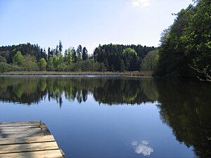
Jägerweiher (Neukirch)
| Hunter pond | ||
|---|---|---|

|
||
| The hunter's pond | ||
| Geographical location | Lake Constance district | |
| Tributaries | Meadow ditches | |
| Drain | via Schwarzach to Schussen | |
| Location close to the shore | Neukirch , Tettnang | |
| Data | ||
| Coordinates | 47 ° 40 '38 " N , 9 ° 41' 12" E | |
|
|
||
| Altitude above sea level | 560 m above sea level NHN | |
| surface | 3.9 ha | |
|
particularities |
Nature reserve since 1990 |
|
The Jägerweiher is a still water in the area of the Baden-Württemberg community Neukirch in the Lake Constance district in Germany.
location
The approximately four hectares large hunters Weiher 2.5 kilometers northwest of the Neukircher town center, between the hamlets of wooden country, Russians Ried, Schnaidt and Zannau, at an altitude of about 560 meters above sea level. Located near the NHN , it is part of the Westallgäu hill country . He is part of the 1990 designated and named after him nature reserve Jägerweiher .
Today it is the last remaining pond in a group of ponds in the Schwarzach valley , which at the time was used for milling and for keeping fish.
Hydrology
The Jägerweiher was created at the end of the last ice age, around 16,000 years ago, as a meltwater lake. The size of the lake basin is 3.9 hectares, the length about 230 meters, the width 110 meters. The inflow of the Jägerweiher takes place via meadow ditches and from the forest of the Untere Langenberg that surrounds the pond , the outflow via a stream in a north-westerly direction to the Schwarzach and further into the Schussen .
ecology
From 2010, the community of Neukirch with the Kreuzweiher , Langensee , Mahlweiher in Ebersberg and Jägerweiher will again be involved in the action program for the rehabilitation of Upper Swabian lakes . An important goal of this lake program is to reduce nutrient inputs in streams, lakes and ponds and thereby improve and maintain the condition of the water bodies.
use
The Jägerweiher is now used for fishing and swimming in a limited area on the northeastern bank.
Flora and fauna
Plants observed in the area of the pond
- Grasblättriges pondweed ( Potamogeton gramineus ), a kind from the family of potamogetonaceae
- Rough horn leaf ( Ceratophyllum demersum ), a submerged aquatic plant from the horn leaf family
- Marsh marigold ( Caltha palustris ), a species of the buttercup family
- Pond horsetail ( Equisetum fluviatile ), a water or bank plant from the horsetail family
- Water knotweed ( Persicaria amphibia ), a species of the knotweed family
- White water lily ( Nymphaea alba ), popularly often referred to as water lily , a species of the water lily family
and animals
- Coot ( Fulica atra ), a species of the railing family
- Reed bunting ( Emberiza schoeniclus ), also known as reed sparrow , is a species of bird in the family of bunting
- Common Moorhen ( Gallinula chloropus ), often referred to as moorhen , also a species from the railing family
- Reed Warbler ( Acrocephalus scirpaceus ), a species of songbird in the warbler family
- Little Grebe ( Tachybaptus ruficollis ), a species of the grebe family
Hiking trails
Several signposted hiking trails run along the pond , including the second stage of the Jubiläumsweg Bodenseekreis , a 111-kilometer hiking trail that was signposted in 1998 to mark the 25th anniversary of the Bodenseekreis. It leads over six stages through the hinterland of Lake Constance from Kressbronn via Neukirch, Meckenbeuren , Markdorf , Heiligenberg and Owingen to Überlingen .
photos
Individual evidence
- ^ Neukircher Nachrichten, page 5; November 20, 2009


