
Oberreute
| coat of arms | Germany map | |
|---|---|---|

|
Coordinates: 47 ° 34 ' N , 9 ° 57' E |
|
| Basic data | ||
| State : | Bavaria | |
| Administrative region : | Swabia | |
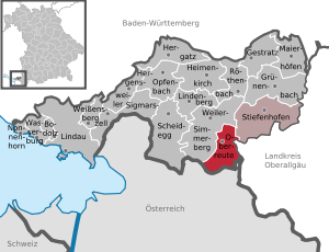
| County : | Lindau (Lake Constance) | |
| Management Community : | Stiefenhofen | |
| Height : | 857 m above sea level NHN | |
| Area : | 13.49 km 2 | |
| Residents: | 1672 (Dec. 31, 2019) | |
| Population density : | 124 inhabitants per km 2 | |
| Postal code : | 88179 | |
| Area code : | 08387 | |
| License plate : | LI | |
| Community key : | 09 7 76 121 | |
| LOCODE : | DE ORU | |
| Community structure: | 15 parts of the community | |
| Association administration address: | Hauptstrasse 8 D-88167 Stiefenhofen |
|
| Website : | ||
| Mayor : | Stefan Schneider (Open Citizens Oberreute) | |
| Location of the municipality of Oberreute in the district of Lindau (Lake Constance) | ||
  |
||


Oberreute ( western Allgäuer Ob e reite ) is a municipality in the Swabian district of Lindau (Lake Constance) , it is a member of the Stiefenhofen administrative community . The place is a state-recognized health resort on the German Alpine Road .
geography
location


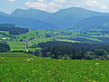
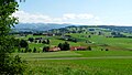
Oberreute is located in the Allgäu region , more precisely in the Westallgäu , about five kilometers from the Austrian border. The municipality is located at an altitude of 680 to 1041 m above sea level. NN .
Parish parts
The municipality has 15 officially named parts of the municipality (the type of settlement is given in brackets ):
|
|
|
The deserted Kremlerbad and Kremler Mill are not officially named districts.
Neighboring communities
| Stiefenhofen | ||
| Hamlet-Simmerberg |
.svg)
|
Oberstaufen |
| Sulzberg (Vorarlberg) |
history
Until the church is planted
The current districts of Stadels and Schönebühl were once the seat of the court. Oberreute only came into being at the end of the 18th century. In 1797 the residents built the first church. The place was part of the Austrian rule Bregenz-Hohenegg, since the peace treaties of Brno and Pressburg in 1805 it belongs to Bavaria.
Population development
- 1961: 1010 inhabitants
- 1970: 1040 inhabitants
- 1987: 1283 inhabitants
- 1991: 1456 inhabitants
- 1995: 1395 inhabitants
- 2000: 1471 inhabitants
- 2005: 1609 inhabitants
- 2010: 1641 inhabitants
- 2015: 1635 inhabitants
Between 1988 and 2018 the municipality grew from 1,283 to 1,662 by 379 inhabitants or by 29.5%
politics
mayor
Mayor after the 2020 election is Stefan Schneider.
Municipal council
After the 2020 election, the municipal council will have 12 members.
coat of arms
The Oberreuter coat of arms shows a silver clearing ax and a silver spade with golden handles crossed over a silver three-mountain.
Economy and Infrastructure
Economy including agriculture and forestry
In 1998, according to official statistics, there were no employees at the place of work who were subject to social security contributions in either the manufacturing or trade and transport sectors. There were a total of 459 employees at the place of residence subject to social insurance contributions. There were six companies in the manufacturing sector and two in the construction sector. In 1999 there were also 54 farms with an agricultural area of 881 ha.
education
In 1999 49 children attended the kindergarten and 82 pupils attended the elementary school in Oberreute, where four teachers taught.
Landscape and nature
- The wild rose moss , a landscape complex of wet meadows and moors , offers a suitable habitat for many rare and protected animal and plant species. As a cross-border natural area between Germany and Austria, it also offers hikers and nature lovers a varied idyll.
- Oberreute shares its most famous geotope, the Hausbachklamm , with Weiler-Simmerberg. The ravine section is around one and a half kilometers long and impresses with erosion and swirl pots in the sand and Nagelfluh rock .
Tourism and sightseeing
- Cross-border nature trail between Oberreute and Sulzberg (A)
- Hausbachklamm with adventure playground
- Nordic Walking Park
- Hiking trails approx. 40 km
- Ski lifts with ski school and ski rental (three drag lifts and a people mover)
- 25 km of cross-country trails
- heated outdoor pool with beach volleyball court and slackline
- Purification treatment according to FX Mayr
- Museum in the town hall
- Ski museum with exhibits from the end of the 19th century
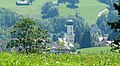
- Parish Church of St. Martin
Events
- Stand concerts in the spa garden
- Summer festivals
- Children's holiday program
- Guest greetings
- Home evenings
- guided snowshoe hikes in winter
- Christmas Market
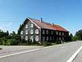
Architectural monuments
German Alpine road B 308 near Oberreute
Oberreute
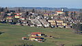
Oberreute from the north
Schönebühl

Oberreute from the east
Irsengund, Oberreute


Personalities
- Johann Evangelist Keller (1824–1910), member of the Reichstag and Landtag, mayor of Lindenberg
- Gunter Steinbach (1938–2002) author of non-fiction books and publisher of a successful series of nature guides, has lived on a farm near Oberreute-Irsengund since the late 1970s.
Partnerships
- La Cumbrecita , Cordoba Province (Argentina) , Argentina . The partnership was signed on March 23, 2019.
Web links
- Entry on the coat of arms of Oberreute in the database of the House of Bavarian History
Individual evidence
- ↑ "Data 2" sheet, Statistical Report A1200C 202041 Population of the municipalities, districts and administrative districts 1st quarter 2020 (population based on the 2011 census) ( help ).
- ^ Municipality of Oberreute in the local database of the Bavarian State Library Online . Bayerische Staatsbibliothek, accessed on August 18, 2019.
- ↑ a b Federal Statistical Office (ed.): Historical municipality register for the Federal Republic of Germany. Name, border and key number changes in municipalities, counties and administrative districts from May 27, 1970 to December 31, 1982 . W. Kohlhammer, Stuttgart / Mainz 1983, ISBN 3-17-003263-1 , p. 786 .
- ↑ https://cfran.cancilleria.gob.ar/userfiles/2018/oberreute_lacumbrecita_convenio_amistad.pdf
Streams | Bump | Hinterschweinhöf | Ihlingshof | Irsengund | Kremler Bath | Kremlin mill | Lengths | Langenried | Oberberg | Oberreute | Faster | Schönebühl | Stadels | Subordinate | Vorderschweinhöf | Zellers
