
Grünenbach
| coat of arms | Germany map | |
|---|---|---|

|
Coordinates: 47 ° 38 ' N , 10 ° 1' E |
|
| Basic data | ||
| State : | Bavaria | |
| Administrative region : | Swabia | |
| County : | Lindau (Lake Constance) | |
| Management Community : | Argental | |
| Height : | 715 m above sea level NHN | |
| Area : | 25.13 km 2 | |
| Residents: | 1510 (Dec. 31, 2019) | |
| Population density : | 60 inhabitants per km 2 | |
| Postal code : | 88167 | |
| Area code : | 08383 | |
| License plate : | LI | |
| Community key : | 09 7 76 113 | |
| Community structure: | 16 parts of the community | |
| Address of the municipal administration: |
Hauptstrasse 50 88167 Grünenbach |
|
| Website : | ||
| Mayor : | Markus Eugler (independent) | |
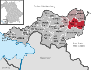
| Location of the community Grünenbach in the district of Lindau (Lake Constance) | ||
  |
||

Grünenbach ( West Allgäu Grien e bach ) is a municipality and a village in the Swabian district of Lindau (Lake Constance) .
geography
Location, districts and highest elevation
Grünenbach is located in the Allgäu region , more precisely in the Westallgäu .
The municipality consists of 2 districts and has 16 officially named municipality parts (the type of settlement is indicated in brackets ):
- District Ebratshofen with Bischlecht ( hamlet ), Ebratshofen ( parish village ), Gerstland ( wasteland ), Hohenegg (hamlet), Oberried (wasteland), horse mountain (hamlet), Schüttentobel (hamlet), Steig (wasteland) and Unterried (hamlet)
- District Grünenbach:
- Old marking Grünenbach with Au (hamlet), Grünenbach (parish village) and Heimhofen ( village )
- Old marking Schönau with Laubenberg (hamlet), Motzgatsried (hamlet), Schneit (wasteland) and Schönau (village)
The highest point is the Laubenberg at 916 meters above sea level. NN.
Neighboring communities
| Gestratz | Maierhöfen | |
| Röthenbach (Allgäu) |
.svg)
|
Weitnau |
| Hamlet-Simmerberg | Stiefenhofen | Missen-Wilhams |
history
Until the church is planted
At the source of the Grüner Bach there is a cult site from prehistoric times , a boulder from Nagelfluh with clearly recognizable prehistoric enclosures.
The Roman-era road from Bregenz to Cambodunum ran through Grünenbach and was an important link for imports from the Mediterranean into the foothills of the Alps (for olive oil, wine, fish sauce, olives).
Until the beginning of the 19th century, the area of today's municipality of Grünenbach belonged to three different territories:
- Grünenbach with Heimhofen and Au: belonged to Austria, rule Bregenz , court Grünenbach .
- Schönau with Schneit, Motzgatsried and Laubenberg: formed the Laubenberg rule . The feudal sovereignty over the rule changed at an unknown point in time from the Prince Abbey of St. Gallen to Austria. The rule belonged to the canton of Hegau-Allgäu-Bodensee of the Imperial Knights' Circle of Swabia . Until 1647 the von Laubenberg family and then the Pappus von Tratzberg family owned the estate .
- Ebratshofen with Schüttentobel, Hohenegg, Oberried, Unterried, Bischlecht, Steig, Gerstland and Horsrenberg: belonged to Austria, rule Bregenz , court Hohenegg. The Hohenegg court consisted of the former Hohenegg lordship , which was a fiefdom of the Kempten Abbey and was united in 1359 with the then Montfort County of Bregenz. In 1451 the Hoheneggian area of Montfort came to Austria. In contrast to the other areas of the Austrian rule of Bregenz (also called "Herrschaft Bregenz-Hohenegg"), the Hohenegg court always retained a certain special status.
At the beginning of the 19th century the areas came under the Kingdom of Bavaria . With the community edict of 1818 , the three modern communities Grünenbach, Schönau and Ebratshofen were created.
Incorporations
In 1860 Schönau was incorporated into Grünenbach, and on April 1, 1972, the previously independent municipality of Ebratshofen was incorporated into Grünenbach.

Population development
- 1961: 1171 inhabitants
- 1970: 1140 inhabitants
- 1987: 1124 inhabitants
- 1991: 1160 inhabitants
- 1995: 1253 inhabitants
- 2000: 1285 inhabitants
- 2005: 1385 inhabitants
- 2010: 1445 inhabitants
- 2015: 1503 inhabitants
Between 1988 and 2018 the municipality grew from 1,116 to 1,460 by 344 inhabitants or by 30.8%.
politics
The community is a member of the administrative community Argental .
mayor
First Mayor is Markus Eugler (non-party, election via the list of independent local councils, since May 2008); this was elected on March 15, 2020 with 91.74% of the votes for a further six years.
Municipal council
After the 2014 election, the municipal council has 12 members.
coat of arms
|
|
Blazon : “Divided and split below; above in silver a green oblique left-hand bar in the shape of a brook, covered with the golden capital letter G, below in front in gold a red-tongued, black bull's body, in the back in red three silver linden leaves diagonally one above the other. "
The current coat of arms has existed since 1972 and represents the three formerly independent communities Grünenbach, Ebratshofen and Schönau. Grünenbach is represented by the community seal used from 1737 and later coat of arms. It shows a green oblique left-hand bar in the shape of a brook covered with the golden capital letter G. The bull's trunk represents Ebratshofen and shows the coat of arms of the Hohenegg family, who formerly lived in Hohenegg Castle near Ebratshofen . The three silver linden leaves show the coat of arms of the Laubenberg knight family and represent Schönau, which was part of the Laubenberg rule. |
Culture and sights
- Eistobel in the nature reserve of the same name
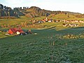
Ebratshofen from the southwest

Grünenbach

Motzgatsried from the southwest

Horse mountain in winter

Memorial stone ruin Altlaubenberg

Schönau from the east


Economy and Infrastructure
Economy including agriculture and forestry
According to official statistics, in 1998 there were 160 employees in the manufacturing sector and no employees in the trade and transport sector at the place of work. In other economic areas, 96 people were employed at the place of work subject to social security contributions. There were 396 employees at the place of residence subject to social security contributions. There were two companies in the manufacturing sector and four in the construction sector. In addition, in 1999 there were 67 farms with an agricultural area of 1415 ha.
traffic
The Allgäu Railway Munich - Lindau runs through the south of the municipality . The next train station is Röthenbach (Allgäu) .
education
In 2010 there were the following institutions:
- Kindergartens: 56 kindergarten places with 56 children
- Elementary school: one with the name Laubenbergschule Grünenbach , built in 2003
Personalities
- Anton Zumstein (1875–1973), cartographer and publisher
- Otto Frommknecht (1881–1969), Bavarian State Minister for Transport from 1947 to 1950
- Katharina Adler (1919–2010), journalist and publicist
- Peter Adler (1923–2012), writer
- Jörg Baldauf (* 1967), former disabled athlete, lives in Schönau
- Suzanne Bernert (* 1982), German-Indian actress
Web links

- http://www.gruenenbach.de Local government
- Grünenbach: Official statistics of the LfStat
Individual evidence
- ↑ "Data 2" sheet, Statistical Report A1200C 202041 Population of the municipalities, districts and administrative districts 1st quarter 2020 (population based on the 2011 census) ( help ).
- ^ Community Grünenbach in the local database of the Bayerische Landesbibliothek Online . Bavarian State Library, accessed on August 28, 2019.
- ↑ Cult place of prehistoric times. Monument number D-7-8326-0018
- ^ Advertisement of the cult site in the Bavaria Atlas
- ↑ Display of the course of the Roman era route in the Bavaria Atlas
- ↑ Schimmer: Amphorae from Cambodunum (Kempten) . 2012, ISBN 978-3-89500-659-3 .
- ^ Wilhelm Volkert (ed.): Handbook of Bavarian offices, communities and courts 1799–1980 . CH Beck, Munich 1983, ISBN 3-406-09669-7 , p. 513 .
- ↑ Mayor. Grünenbach community, accessed on August 7, 2020 .
- ↑ Archived copy ( memento of the original from January 14, 2018 in the Internet Archive ) Info: The archive link was inserted automatically and has not yet been checked. Please check the original and archive link according to the instructions and then remove this notice.
- ^ Entry on the coat of arms of Grünenbach in the database of the House of Bavarian History
- ^ Ludwig Scheller: Contributions to the local history of the community Grünenbach . No. 1 , 1959, p. 78 .
- ^ House of Bavarian History - Bavaria's municipalities. Retrieved August 28, 2018 .
Au | Bischlecht | Ebratshofen | Gallows Builder | Gerstland | Grünenbach | Heimhofen | Hohenegg | Laubenberg | Motzgatsried | Oberried | Horse Mountain | Snowing | Schönau | Schüttentobel | Climb | Unterried | Zwerenberg
