
Maierhöfen
| coat of arms | Germany map | |
|---|---|---|

|
Coordinates: 47 ° 39 ' N , 10 ° 3' E |
|
| Basic data | ||
| State : | Bavaria | |
| Administrative region : | Swabia | |
| County : | Lindau (Lake Constance) | |
| Management Community : | Argental | |
| Height : | 741 m above sea level NHN | |
| Area : | 17.93 km 2 | |
| Residents: | 1611 (Dec. 31, 2019) | |
| Population density : | 90 inhabitants per km 2 | |
| Postal code : | 88167 | |
| Area code : | 08383 | |
| License plate : | LI | |
| Community key : | 09 7 76 118 | |
| LOCODE : | DE MHB | |
| Community structure: | 35 parts of the community | |
| Association administration address: | Mühlenstrasse 1 88167 Röthenbach (Allgäu) |
|
| Website : | ||
| Mayor : | Martin Black | |
| Location of the municipality of Maierhöfen in the district of Lindau (Lake Constance) | ||
  |
||

Maierhöfen ( westallgäuerisch Moi e hef e or Moi e hef) is a municipality in the Swabian district of Lindau (Bodensee) and a member of the administrative community Argental .
geography
Location and district
Maierhöfen is in the Allgäu region , more precisely in the Westallgäu . There is only one Maierhöfen district in the municipality .
Parish parts
The municipality has 35 officially named municipal parts (the type of settlement is given in brackets ):
|
|
|
In the vernacular is Büchlenberg Bichl Berg , Grub Grueb , Happach Happa , Hochstädt, Hofstädten and Stockach Stocka . The hamlet of Hochberg is not an officially named district.
Neighboring communities
| Isny in the Allgäu | ||
| Gestratz |
.svg)
|
|
| Grünenbach | Weitnau |
history
Until the church is planted
Already in the year 14 a Roman road led over Grünenbach and Maierhöfen. In 1290 a Maierhof was mentioned in Riedholz, already in 1474 Maigerhof ze Maigerhofen , with the separation of a separate parish from Grünenbach in 1811 the church of St. Gebhard was built. The castle Ringenberg , already mentioned in 1230, was forcibly auctioned off to the castle builders in 1776.
Maierhöfen initially belonged to Austria as part of the Austrian rule of Bregenz-Hohenegg. Since the peace treaties of Brno and Pressburg in 1805, the place has belonged to the newly formed Kingdom of Bavaria . In the course of the administrative reforms in the Kingdom of Bavaria, today's municipality was created with the municipal edict of 1818 .
Population development
- 1970: 1133 inhabitants
- 1987: 1306 inhabitants
- 1991: 1414 inhabitants
- 1995: 1480 inhabitants
- 2000: 1503 inhabitants
- 2005: 1576 inhabitants
- 2010: 1586 inhabitants
- 2015: 1571 inhabitants
Between 1988 and 2018 the municipality grew from 1,328 to 1,598 by 270 inhabitants or by 20.3%.
politics
mayor
Martin Schwarz (community of voters) has been mayor since May 1996.
Town hall and local council
The seat of the municipal administration is Brunnenweg 2.
After the 2014 election, the municipal council has 12 members.
coat of arms
The coat of arms of the municipality of Maierhöfen shows a silver Roman watchtower above a silver shield base with a continuous red bar cross in red, crossed at an angle, topped with a golden sword and a golden key.
Culture and sights

- Parish Church of St. Gebhard
- Eistobel in the nature reserve of the same name
- Hengelesweiher
- Flucken and Iberg ski lifts
- Specialization in tourism offers for the blind and visually impaired
- Sculpture trail from Maierhöfen (circular hiking trail with 16 sculptures over 4.7 km in length)
Architectural monuments
Soil monuments
Economy and Infrastructure
Economy including agriculture and forestry

In 1998, according to official statistics, there were no employees at the place of work in the manufacturing industry 62 or in the trade and transport sector. In other economic sectors, 242 people were employed at the place of work subject to social security contributions. There were a total of 375 employees at the place of residence subject to social insurance contributions. There were no companies in the manufacturing sector and six in the construction sector. In addition, in 1999 there were 60 farms with an agriculturally used area of 1150 ha, all of which were permanent green areas.
education
In 1999 the following institutions existed:
- Kindergarten: 50 kindergarten places with 52 children
Resort
Maierhöfen and its entire municipality have been a state-approved resort for many decades. In 2015, 964 beds were available to guests.
Personalities
Sons and daughters of the church
- Leo Hiemer (* 1954), filmmaker
People who worked on site
- René Giessen (* 1944), German musician, lives in Maierhöfen

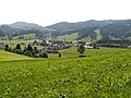
Maierhöfen in the Westallgäu with the Säntis
Maierhöfen from the west

Riedholz

View from the Riedholzer Kugel to the west


Web links
- Official website of the Maierhöfen community
- Entry on the coat of arms of Maierhöfen in the database of the House of Bavarian History
Individual evidence
- ↑ "Data 2" sheet, Statistical Report A1200C 202041 Population of the municipalities, districts and administrative districts 1st quarter 2020 (population based on the 2011 census) ( help ).
- ^ Municipality of Maierhöfen in the local database of the Bayerische Landesbibliothek Online . Bayerische Staatsbibliothek, accessed on August 18, 2019.
- ^ Hohenegg, Herrschaft , in: Historisches Lexikon Bayerns
- ↑ Archived copy ( memento of the original from July 4, 2016 in the Internet Archive ) Info: The archive link was inserted automatically and has not yet been checked. Please check the original and archive link according to the instructions and then remove this notice.
On the other hand | Berries | Brat | Tucks | Birkach | Buchers | Büchlenberg | Honestly | Flucken | Greit | Grub | Gschwend | Happach | Hochberg | Hochstädt | Kitzensberg | Linden | Maierhöfen | Nail rings | Neppen | Obersteig | Raschenberg | Tail | Riedholz | Ringenberg | Schanz | Sharp furniture | Blacks | Schweinbach | Steinlishof | Stockach | Strass | Untersteig | Forewood | Warm heaps | Wolfbuehl
