
Stiefenhofen
| coat of arms | Germany map | |
|---|---|---|

|
Coordinates: 47 ° 36 ' N , 10 ° 0' E |
|
| Basic data | ||
| State : | Bavaria | |
| Administrative region : | Swabia | |
| County : | Lindau (Lake Constance) | |
| Management Community : | Stiefenhofen | |
| Height : | 805 m above sea level NHN | |
| Area : | 28.98 km 2 | |
| Residents: | 1886 (Dec. 31, 2019) | |
| Population density : | 65 inhabitants per km 2 | |
| Postal code : | 88167 | |
| Area code : | 08383 | |
| License plate : | LI | |
| Community key : | 09 7 76 127 | |
| Community structure: | 26 parts of the community | |
| Address of the municipal administration: |
Main street 8 88167 Stiefenhofen |
|
| Website : | ||
| Mayor : | Christian Hauber (List of Future Stiefenhofen) | |
| Location of the municipality of Stiefenhofen in the district of Lindau (Lake Constance) | ||
  |
||

Stiefenhofen ( westallgäuerisch Schtief e hof e ) is a municipality in the Bavarian-Swabian district of Lindau (Bodensee) and the seat of the administrative community Stiefenhofen .

geography
Location and districts
Stiefenhofen is located in the Allgäu region , more precisely in the Westallgäu , not far from Lake Constance . There exist Gemarkungen Harbatshofen ( 47 ° 36 ' N , 10 ° 0' O ) and Stiefenhofen. The lowest point of the district is at 750 m, the highest at 1067 m.
Parish parts
The municipality has 26 officially named parts of the municipality (the type of settlement is indicated in brackets ):
|
|
|
The desert areas of Hinteregg , Lerchenmühle , Rastmühle and Tobelmühle are not officially designated parts of the municipality.
Neighboring communities
| Grünenbach | Weitnau | |
| Hamlet-Simmerberg |
.svg)
|
Missen-Wilhams |
| Oberreute | Oberstaufen |
history
Until the church is planted
The place Stoufun is mentioned in a Sankt Gallen document from the year 868. 883 another Sankt Gallen document names STIVUNHOVARO MARCHA (= Stiefenhofen).
In the Old Kingdom , today's municipality of Stiefenhofen was spread over different territories:
- County of Rothenfels (House Königsegg , Swabian District ): Stiefenhofen, Aich, Buch, Genhofen, Hahnschenkel, Hopfen, Iringshofen, Mutten, Ranzenried, Schwanden, Trabers, Wolfsried
-
Lordship of Bregenz ( Upper Austria , Austrian District )
- Grünenbach court : Harbatshofen, Hertnegg, Holzleute, Isenbretshofen, Lautenberg, Mittelhofen, Rutzhofen
- Simmerberg court : Balzhofen, Berbruggen, Burkatshofen
- Hohenegg court (= former Hohenegg rule ): Gschwend, Jungensberg, Oberthalhofen, Unterthalhofen
At the beginning of the 19th century the towns became part of the Kingdom of Bavaria . In the course of the administrative reforms in Bavaria , the municipality of Stiefenhofen was created with the municipal edict of 1818 .
Territorial reform
As a result of the regional reform in Bavaria , the formerly independent municipality of Harbatshofen was incorporated on July 1, 1970. At the same time parts of the area were assigned to the Oberstaufen market .
On July 1, 1972, the community was spun off from the then Sonthofen district and integrated into the Lindau district (Lake Constance).
Population development
The following inhabitants were counted in the municipality:
| 1961 | 1589 |
| 1970 | 1557 |
| 1987 | 1498 |
| 1991 | 1628 |
| 1995 | 1612 |
| 2000 | 1665 |
| 2005 | 1719 |
| 2010 | 1788 |
| 2015 | 1842 |
Between 1988 and 2018 the municipality grew from 1,508 to 1,857 by 349 inhabitants or 23.1%.
politics
mayor
Anton Wolf (CSU / Free Voters) has been mayor since 1990; he was re-elected in 1996, 2002, 2008 and 2014.
Municipal council
After the 2014 election, the municipal council has 12 members.
coat of arms
The coat of arms of the municipality of Stiefenhofen, assigned in 1973, is divided diagonally by silver and blue. It shows a sloping black step beam at the top, a golden bird (crossbill) below.
Economy and Infrastructure
Economy including agriculture and forestry
According to official statistics, there were 89 employees subject to social insurance contributions in the manufacturing sector in 1998, but none in the trade and transport sector. In other economic areas, 80 people were employed at the place of work subject to social security contributions. In total there were 562 employees subject to social security contributions at the place of residence. There were five companies in manufacturing and eight in construction. In addition, in 1999 there were 110 farms with 1966 hectares of agriculturally used green space. In 2017, the municipality still reported 105 farms.
education
Facilities (status: 1999):
- Kindergarten: 50 kindergarten places with 49 children
- Elementary school: one with four teachers and 87 students
Culture and sights
Stephanskapelle in Genhofen

The district of Genhofen is located on an important historical thoroughfare, which was probably laid out by the Romans around the year 250. In the Middle Ages, salt, the “white gold” of that time, was transported from Immenstadt to Simmerberg . Genhofen was before the dreaded climb to the Hahnschenkel. In this context, the St. Stephen's Chapel was created with its frescoes from the late 15th century, largely preserved in the original . Your builder was Magister Conrad Schilling. The three late Gothic shrine altars inside are of remarkable quality. The pictures of the choir altar are by Adam Schlan (t) z, the court painter of the prince abbot of Kempten. The sculptures are attributed to Michael Zeynsler († after 1559); they show the Augsburg bishop St. Ulrich , Mary with child and the apostle James the Elder . In addition to James, there is a second patron saint of travelers, St. Christophorus . The door to the sacristy is decorated with a few dozen horseshoes.
Architectural monuments
tourism
- Stiefenhofen has dedicated itself to the topic of "herbs": herb farm, herb tours, herb kitchen. The “Artemisia” natural garden is located in the Hopfen district, a huge herb garden, herb nursery with a factory, café, shop and seminars.
- Cross-country skiing trails
- The Bavarian-Swabian Jakobusweg leads through Genhofen
- vacation on the farm
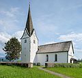
Filial church St. Stephanus (called Stephanuskapelle) Genhofen

Jungensberg

Upper evil

Oberthalhofen from the southeast

Dwindling

Stiefenhofen from the southwest

Wolfsried


Sports
After the football club TSV Stiefenhofen was founded in 1981, the team played for the first time in their club's history in the regional league A of the Württemberg Football Association.
Web links
- Entry on the coat of arms of Stiefenhofen in the database of the House of Bavarian History
Individual evidence
- ↑ "Data 2" sheet, Statistical Report A1200C 202041 Population of the municipalities, districts and administrative districts 1st quarter 2020 (population based on the 2011 census) ( help ).
- ↑ Archived copy ( memento of the original from April 17, 2017 in the Internet Archive ) Info: The archive link was inserted automatically and has not yet been checked. Please check the original and archive link according to the instructions and then remove this notice.
- ^ Community Stiefenhofen in the local database of the Bayerische Landesbibliothek Online . Bayerische Staatsbibliothek, accessed on August 18, 2019.
- ↑ http://www.leo-bw.de/media/kgl_atlas/current/delivered/bilder/HABW_06_13.jpg ; http://geschichte.digitale-sammlungen.de/hab/band/bsb00008060
- ^ Wilhelm Volkert (ed.): Handbook of Bavarian offices, communities and courts 1799–1980 . CH Beck, Munich 1983, ISBN 3-406-09669-7 , p. 513 .
- ^ Chronicle of the Lindau district
- ↑ http://www.wahlen.bayern.de/kommunalwahlen/
- ↑ http://www.stiefenhofen.de/index.shtml?Gemeinderat ( page no longer available , search in web archives ) Info: The link was automatically marked as defective. Please check the link according to the instructions and then remove this notice.
- ^ Artemisia herb garden
Aich | Balzhofen | Berbruggen | Book | Burkatshofen | Genhofen | Gschwend | Rooster legs | Harbatshofen | Hertnegg | Wood people | Hops | Iringshofen | Isenbretshofen | Jungensberg | Lautenberg | Mittelhofen | Mutten | Oberthalhofen | Ranzenried | Rutzhofen | Schwanden | Stiefenhofen | Trotters | Unterthalhofen | Wolfsried
