
Moerfelden
|
Moerfelden
City of Mörfelden-Walldorf
|
|
|---|---|
 |
|
| Height : | 98 m above sea level NHN |
| Residents : | 16,711 (2016) |
| Incorporation : | January 1, 1977 |
| Incorporated into: | Waldfelden |
| Postal code : | 64546 |
| Area code : | 06105 |
 Aerial view of Moerfelden
|
|


Mörfelden (dialect: Merfelle ) is a suburb of Mörfelden-Walldorf in the Groß-Gerau district in southern Hesse .
Geographical location
Mörfelden is located on a cleared island in the wooded sub -Main plain in the Rhine-Main area , in the triangle between the southern Hessian cities of Frankfurt am Main , Darmstadt and Mainz and south of Frankfurt Airport . In the east-west direction, the district is drained by the Gundbach in the north, the Geräthsbach in the middle and the Hegbach in the south. In the west, the district has a share in the extensive nature reserve Mönchbruch . East of Mörfelden, at the National Highway 5 , are the upper Forest Lake , and the resultant from a former landfill Oberwaldberg , 145 meters is the highest point in the circuit large-Gerau.
The closest localities are in the north, just under four kilometers away, the suburb of Walldorf, in the east Langen , Egelsbach and Erzhausen , in the south Weiterstadt with the districts of Graefenhausen and Schneppenhausen and the municipality of Büttelborn with the parts Worfelden and Klein-Gerau , in the southwest Groß- Gerau and Nauheim as well as the Rüsselsheim districts Königstädten and Haßloch in the west and finally the town of Raunheim in the northwest .
history
The existence of the place can be traced back to the years 830-850 as a Franconian imperial estate in the Reichsforst und Wildbann Dreieich in the Codex Laureshamensis in the then spelling Mersenuelt .
Finds from burial mounds in the area suggest that settlements existed here as early as the Bronze Age. On the southern edge of the village, the site of an abandoned moated castle , Mörfelden Castle, was discovered. There are no more building remains, and there are no documents about the construction and the fall of the castle.
Already in Roman times, many roads led through this area. As an important trading and traffic center, Mörfelden received its own customs office in the 15th century. The trucking trade was of great importance on the spot.
Around 1232 a chapel is mentioned in Mersenvelt and in 1304 an ecclesia parochialis as a "parish church with a branch on the Gundhof".
The Thirty Years' War also hit Mörfelden hard. Due to acts of war and the plague, great human losses and destruction were to be lamented. In 1694 only 159 inhabitants were recorded.
In 1600 Mörfelden came to the Landgraviate of Hesse-Darmstadt and in 1806 to the Grand Duchy of Hesse . Administratively, Mörfelden in Hesse belonged to the Kelsterbach office until 1821 . Due to the administrative reform of 1821 in the Grand Duchy of Hesse, the place is assigned to the district of Langen in the province of Starkenburg .
The statistical-topographical-historical description of the Grand Duchy of Hesse reports on Mörfelden in 1829:
»Mörfelden (L. Bez. Langen) Lutheran parish village; is 2 St. from Langen, and has 142 houses and 991 inhabitants, who are Lutheran except for 2 Cath. and 45 Jews. The place is surrounded by a very wide dry moat, over which 2 bridges lead. A start has been made on the site towards Langen with a new building complex; you will find 1 mill and 1 brickworks. - Mörfelden appears in Lorsch documents under the name Mersenvelt . In 1504 Philipp von Falkenstein ceded his tithes to the parish in Mörfelden and at the Gundhofe in return for an annual fruit lease, and in 1383 another Philipp von Falkenstein granted the benefit of the tithes to Mörfelden and the Gundhofe to the pastor at the time, Heinrich von Münzenberg Lifelong. Archbishop Conrad moved customs from Mainz to Mörfelden in 1421. The place came from Isenburg in 1600 with the entire Kelsterbach office through purchase to Hesse. "
1832 Province Starkenburg is then in circles divided and Morfelden get to the district of Gross-Gerau . It belongs to this group until today, only interrupted by the division of Starkenburg into administrative districts. From 1848 to 1852 it was part of the Darmstadt administrative region .
The responsible jurisdiction was during the affiliation to Hesse, from 1821 to 1879 the district court Langen and from 1879 the resulting district court Langen . The Groß-Gerau district court has been responsible for Mörfelden since 1883 .
The 19th century brought Mörfelden a slow but steady upward development. With the commissioning of the Riedbahn by the Hessian Ludwigsbahn in November 1879, the upswing intensified. As early as the middle of the 19th century, numerous residents commuted to the nearby large cities. As a result, Mörfelden increasingly transformed itself from a farming village into a workers' community. Many Mörfelder were active in the construction industry. Colloquially, Mörfelden was therefore called the mason village .
After the Second World War and the currency reform in 1948 , Mörfelden first grew through the reception of expellees and refugees and later through the stormy economic development of the Rhine-Main area . For the constantly growing population, new residential and commercial areas had to be developed and the performance of the infrastructure expanded.
The municipality of Mörfelden was granted the right to use the designation city on March 5, 1968 by the Hessian state government .
In the course of the regional reform in Hesse , the cities of Mörfelden and Walldorf were merged to form the city of Waldfelden . A year later, at the request of the newly founded city, the name was changed to Mörfelden-Walldorf .
Territorial history and administration
The following list gives an overview of the territories in which Mörfelden was located and the administrative units to which it was subordinate:
- before 1604 Holy Roman Empire , Grafschaft Isenburg-Ronneburg , Amt Langen
- from approx. 1604: Holy Roman Empire, Landgraviate of Hesse , Upper County of Katzenelnbogen , Kelsterbach Office
- from 1803: Holy Roman Empire, Landgraviate Hessen-Darmstadt, Principality of Starkenburg , Kelsterbach Office
- from 1806: Grand Duchy of Hesse , Principality of Starkenburg, Kelsterbach Office
- from 1815: German Confederation , Grand Duchy of Hesse, Province of Starkenburg , Kelsterbach Office
- from 1821: German Confederation, Grand Duchy of Hesse, Starkenburg Province, Langen District District (separation between justice ( Langen District Court ) and administration)
- from 1832: German Confederation, Grand Duchy of Hesse, Province of Starkenburg, District of Groß-Gerau
- from 1848: German Confederation, Grand Duchy of Hesse, Darmstadt administrative district
- from 1852: German Confederation, Grand Duchy of Hesse, Province of Starkenburg, District of Groß-Gerau
- from 1866: Grand Duchy of Hesse, Starkenburg Province, Groß-Gerau district
- from 1871: German Empire , Grand Duchy of Hesse, Starkenburg Province, Groß-Gerau district
- from 1918: German Empire, People's State of Hesse , Starkenburg Province, Groß-Gerau district
- from 1938: German Empire, People's State of Hesse, Groß-Gerau district (In the course of the regional reform in 1938 , the three Hessian provinces of Starkenburg, Rheinhessen and Upper Hesse are dissolved.)
- from 1945: American occupation zone , Greater Hesse , Darmstadt administrative district, Gross-Gerau district
- from 1949: Federal Republic of Germany , State of Hesse , Darmstadt district, Groß-Gerau district
- 1968: elevation to the city
- on January 1, 1977: Merger with Walldorf to form the city of Waldfelden
Umgemeindungen
On April 1, 1953, the residential areas Gundhof with part of the Gundwald and Schlichter with four residents came from the community of Walldorf to the community of Mörfelden. In addition, the Mönchbruch residential area with 118 residents from Rüsselsheim and the Nikolauspforte with a residential building (15 residents altogether) from Groß-Gerau were added.
Population development
The population of Mörfelden rose slowly but steadily in the 19th century to 1875 from 1097 in 1834 to 1696 in 1875. The development accelerated until the turn of the century. In 1905 there were 3324 inhabitants. Before the Second World War in 1939 the number was 5409 and in 1946 it was 6368. In the 1960s the increase was almost explosive: from 9042 inhabitants (1961) to 12,303 on March 31, 1972, that is over 3000 inhabitants in ten years.
| • 1629: | 75 house seats |
| • 1694: | 159 inhabitants |
| • 1791: | 668 inhabitants |
| • 1800: | 720 inhabitants |
| • 1806: | 810 inhabitants, 127 houses |
| • 1829: | 991 inhabitants, 142 houses |
| • 1867: | 1595 inhabitants, 234 houses |
| Mörfelden: Population from 1791 to 2015 | ||||
|---|---|---|---|---|
| year | Residents | |||
| 1791 | 668 | |||
| 1800 | 720 | |||
| 1806 | 810 | |||
| 1829 | 991 | |||
| 1834 | 1,097 | |||
| 1840 | 1,214 | |||
| 1846 | 1,357 | |||
| 1852 | 1,440 | |||
| 1858 | 1,460 | |||
| 1864 | 1,558 | |||
| 1871 | 1,692 | |||
| 1875 | 1.996 | |||
| 1885 | 2.174 | |||
| 1895 | 2,497 | |||
| 1905 | 3,324 | |||
| 1910 | 3,784 | |||
| 1925 | 4,398 | |||
| 1939 | 5,409 | |||
| 1946 | 6,368 | |||
| 1950 | 7.091 | |||
| 1956 | 8,731 | |||
| 1961 | 9,042 | |||
| 1967 | 11,170 | |||
| 1970 | 11,798 | |||
| 1978 | 13,248 | |||
| 1985 | 13,852 | |||
| 1990 | 14,469 | |||
| 1995 | 15,484 | |||
| 2000 | 15,868 | |||
| 2005 | 15,511 | |||
| 2010 | 15,796 | |||
| 2011 | 15,435 | |||
| 2015 | 16,597 | |||
| Data source: Historical municipality register for Hesse: The population of the municipalities from 1834 to 1967. Wiesbaden: Hessisches Statistisches Landesamt, 1968. Further sources:; 2011 census | ||||
Religious affiliation
| • 1829: | 944 Lutheran (= 95.26%), 45 Jewish (= 4.54%) and 2 Catholic (= 0.20%) residents |
| • 1961: | 5504 Protestant (= 60.87%), 1971 Catholic (= 21.80%) residents |
Culture and sights
Buildings
- Water tower
- The landmarked, around 35 m high tower on Frankfurter Strasse is a landmark of Mörfelden. The structure, which is now closed, was built in 1929 together with a waterworks.
- Old Town Hall
- The old town hall is located at Langener Straße 4 on the " Dalles ". Today it houses the social and housing office (as of 2017). The two-story structure was built in 1876. In 1996 there was a complete renovation and the extension with a single-storey extension.
- Fountain "narrative stone"
- In 1992 Reiner Uhl created the fountain in front of the old town hall. The so-called narrative stone depicts scenes from the city's history. It also addresses problems such as air traffic and other traffic loads.

Moerfelden water tower
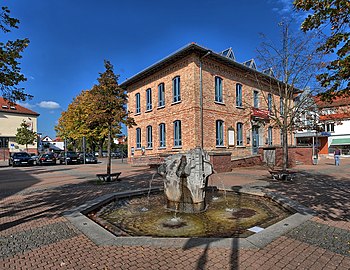
Old town hall Mörfelden
with fountain
Story stone
water tower construction
Telling stone
traffic load


- Protestant church
- The Evangelical Church in Mörfelden is a baroque building that was built in 1729 on the remains of a previous building from the 14th century. In 1827 there was an extension. On the outer wall there are epitaphs from the 16th and 18th centuries. The building has been a listed building since 1936. In the years 1964–67 the church was renovated.
- Hofreite "Golden Apple" - tavern and local history museum
- The historic inn at Langgasse 45 has existed since 1751. In the back of the Hofreite is the local history museum, which was set up in 1990 and gives an insight into the history of Mörfelden.
Historic inn "Goldener Apfel"

Local history museum Mörfelden


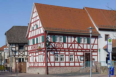
- Historic half-timbered houses

Old forge from 1693
(Hintergasse 6)

Half-timbered house (Dreihäusergasse)


- Mönchbruch hunting lodge
- On the B 486, about five kilometers west of Mörfelden, is the Mönchbruch hunting lodge , which was built in 1730 by Landgrave Ernst-Ludwig of Hesse-Darmstadt .
- Forsthaus Wiesental
- Two kilometers south of Mörfelden is the forester's lodge of the Apfelbachbrücke district forester. The building is the only surviving pavilion of a hunting grounds built by Landgrave Ernst-Ludwig in 1725 .

Forsthaus Wiesental


Regular events
- October: curb
traffic
In Mörfelden, the federal highway 44 from Frankfurt am Main via Groß-Gerau to Mannheim and the federal highway 486 from Rüsselsheim am Main via Langen to Eppertshausen near Dieburg cross . Via the B 486 there is a junction with the federal motorway 5 almost two kilometers east of the town . The state road L 3113 leads south via Graefenhausen to Darmstadt .
The Riedbahn from Frankfurt am Main to Mannheim has been expanded on the one hand for high-speed traffic up to 200 km / h, on the other hand the Mörfelden station is the station for the regional train RE 70 and for the S-Bahn line 7 of the S-Bahn Rhein-Main . After Frankfurt (Main) main station and the journey takes about 20 minutes. There are also bus routes to Frankfurt am Main Airport Terminal 1.
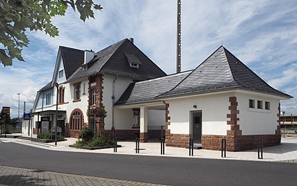
Station building
built in 1903 - renovation 2010/11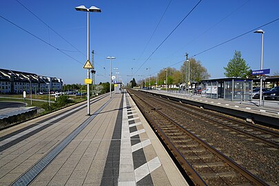
Platforms after the renovation


Web links
- Internet presence of the city of Mörfelden-Walldorf
- Mörfelden, Groß-Gerau district. Historical local dictionary for Hessen. In: Landesgeschichtliches Informationssystem Hessen (LAGIS).
Individual evidence
- ↑ a b Budget 2019 (PDF; 76 MB) City of Mörfelden-Walldorf, pp. 148–49 , accessed in April 2019 .
- ↑ Darmstädter Echo, Wednesday, October 8, 2014, p. 20: Roses for women ( memento of October 19, 2014 in the Internet Archive )
- ^ A b c Georg W. Wagner: Statistical-topographical-historical description of the Grand Duchy of Hesse: Province of Starkenburg . tape 1 . Carl Wilhelm Leske, Darmstadt October 1829, p. 159 ( online at Google Books ).
- ↑ a b c d e f g Mörfelden, Groß-Gerau district. Historical local dictionary for Hesse (as of October 16, 2018). In: Landesgeschichtliches Informationssystem Hessen (LAGIS). Hessian State Office for Historical Cultural Studies (HLGL)
- ^ City history: Mörfelden. In: website. City of Mörfelden-Walldorf, accessed December 2018 .
- ↑ Granting of the right to use the designation “city” to the municipality of Mörfelden, Groß-Gerau district on March 18, 1968 . In: The Hessian Minister of the Interior (ed.): State Gazette for the State of Hesse. 1968 No. 21 , p. 826 , point 593 ( online at the information system of the Hessian state parliament [PDF; 3.6 MB ]).
- ↑ Law on the reorganization of the district of Groß-Gerau (GVBl. II 314–32) of July 26, 1974 . In: The Hessian Minister of the Interior (ed.): Law and Ordinance Gazette for the State of Hesse . 1974 No. 22 , p. 314 , § 5 ( online at the information system of the Hessian state parliament [PDF; 1.5 MB ]).
- ^ Michael Rademacher: German administrative history from the unification of the empire in 1871 to the reunification in 1990. State of Hesse. (Online material for the dissertation, Osnabrück 2006).
- ^ Grand Ducal Central Office for State Statistics (ed.): Contributions to the statistics of the Grand Duchy of Hesse . tape 1 . Darmstadt 1866, p. 43 ff . ( online at Google Books ).
- ↑ a b List of offices, places, houses, population. (1806) HStAD inventory E 8 A No. 352/4. In: Archive Information System Hessen (Arcinsys Hessen), as of February 6, 1806.
- ^ Local elections 1972; Relevant population of the municipalities on August 4, 1972 . In: The Hessian Minister of the Interior (ed.): State Gazette for the State of Hesse. 1972 No. 33 , p. 1424 , point 1025 ( online at the information system of the Hessian state parliament [PDF; 5.9 MB ]).
- ↑ Hessen-Darmstadt state and address calendar 1791 . In the publishing house of the Invaliden-Anstalt, Darmstadt 1791, p. 121 ( online in the HathiTrust digital library ).
- ↑ Hessen-Darmstadt state and address calendar 1800 . In the publishing house of the Invaliden-Anstalt, Darmstadt 1800, p. 122 ( online in the HathiTrust digital library ).
- ^ Ph. AF Walther : Alphabetical index of the residential places in the Grand Duchy of Hesse . G. Jonghaus, Darmstadt 1869, OCLC 162355422 , p. 58 ( online at google books ).
- ↑ Budget 2013. (PDF; 3.5 MB) City of Mörfelden-Walldorf, pp. 12-13 , accessed in April 2019 .
- ↑ Selected data on population and households on May 9, 2011 in the Hessian municipalities and parts of the municipality. In: 2011 census . Hessian State Statistical Office
- ↑ Evangelical Church Community Mörfelden - Our Church. Retrieved April 20, 2019 .
- ↑ Notch. In: Calendar, Darmstädter Schaustellerverband e. V., Darmstadt 2019.