
Oath
|
Oath
municipality Michelau
Coordinates: 50 ° 10 ′ 7 ″ N , 11 ° 9 ′ 2 ″ E
|
|
|---|---|
| Height : | 287 m above sea level NHN |
| Residents : | 1446 (June 30, 2017) |
| Incorporation : | January 1, 1978 |
 Fischerhof
|
|
Schwürbitz is a district of the municipality of Michelau in the Upper Franconian district of Lichtenfels .
geography
Schwürbitz is located on the Main , at an altitude of 287 m above sea level. NHN and has 1446 inhabitants (as of June 30, 2017). It is located at the northernmost point of the Main.
history
- 1180 Foundation as "Sworbs sub monte cortze". Bishop Otto II gave the monks of the Langheim monastery a place at the foot of the mountain "Göritze", which was to be expanded to become the base of the monastery.
- The first documentary mention was in the Bamberg Cathedral nekrolog (1285–1287) in a report on an exchange acquisition of the cathedral monastery as "de Swrbez ... cum Swrbeze ... de Swrbeze".
- In 1840 the population was 960.
- 1899 consecration of the Sacred Heart Church
- 1901 Construction of an iron bridge over the Main
- 1906 flood disaster. Break of the dam at the Gruber hamlet
- In 1927 the Protestant parish church was consecrated
- 1945 The Main Bridge is blown up
- 1975 Damage from a windpipe
On January 1, 1978 Schwürbitz was incorporated into the community of Michelau in Upper Franconia.
Both denominations were strongly represented in Schwürbitz in the 19th century. In 1875 there were 845 Catholics and 315 Protestants in the village. The result was that every denomination had a school and a church. Even today the Catholic and Protestant cemeteries are separated by a wall.

Evangelical Lutheran parish church
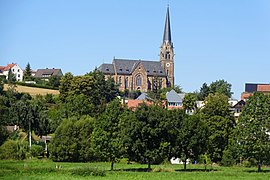
catholic parish church Herz Jesu
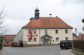
Old Town Hall


Web links
Individual evidence
- ^ Geographical names of Germany (GN-DE). Retrieved August 28, 2014 .
- ↑ Homepage of the community of Michelau. Retrieved August 28, 2014 .
- ^ Dieter George: Lichtenfels; The old circle . Historical book of place names of Bavaria. Upper Franconia. Volume 6: Lichtenfels. Commission for Bavarian State History, Munich 2008, ISBN 978 3 7696 6862 9 . P. 138.
- ↑ Thomas Gunzelmann: The cultural landscape around 1840 . In: Günther Dippold: In the upper Main Valley on the Jura an Rodach and Itz , self-published by Kreissparkasse Lichtenfels, Lichtenfels 1990, p. 75
- ^ Federal Statistical Office (ed.): Historical municipality directory for the Federal Republic of Germany. Name, border and key number changes in municipalities, counties and administrative districts from May 27, 1970 to December 31, 1982 . W. Kohlhammer GmbH, Stuttgart and Mainz 1983, ISBN 3-17-003263-1 , p. 695 .
- ↑ Kgl. Statistical Bureau (ed.): Complete list of localities of the Kingdom of Bavaria. According to districts, administrative districts, court districts and municipalities, including parish, school and post office affiliation ... with an alphabetical general register containing the population according to the results of the census of December 1, 1875 . Adolf Ackermann, Munich 1877, 2nd section (population figures from 1871, cattle figures from 1873), Sp. 1078 , urn : nbn: de: bvb: 12-bsb00052489-4 ( digitized ).
- ↑ Obermain-Tagblatt, March 31, 2017