Rothsee
| Rothsee | |||||||||
|---|---|---|---|---|---|---|---|---|---|
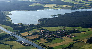
| Rothsee with the Rhine-Main-Danube Canal in the foreground (2010) | |||||||||
|
|||||||||
|
|
|||||||||
| Coordinates | 49 ° 13 '13 " N , 11 ° 11' 3" E | ||||||||
| Data on the structure | |||||||||
| Construction time: | 1985-1993 | ||||||||
| Height of the barrier structure : | 16 m | ||||||||
| Height of the structure crown: | 377.2 m above sea level NN | ||||||||
| Building volume: | 0.8 million m³ | ||||||||
| Crown length: | 1.7 km | ||||||||
| Power plant output: | 750 kW, 898 kW | ||||||||
| Data on the reservoir | |||||||||
| Altitude (at congestion destination ) | 374.2 m above sea level NN (summer) 373.7 m above sea level NN (winter) | ||||||||
| Water surface | 1.6 km² | ||||||||
| Reservoir length | 3.7 km | ||||||||
| Reservoir width | 1.6 km | ||||||||
| Storage space | 7.9 million m³ | ||||||||
| Total storage space : | 11.7 million m³ | ||||||||
| Pre-lock | |||
|---|---|---|---|
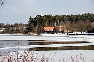
| Pre-lock in winter (2013) | |||
|
|
|||
|
|
|||
| Coordinates | 49 ° 13 ′ 38 " N , 11 ° 11 ′ 43" E | ||
| Data on the structure | |||
| Height of the barrier structure : | 11 m | ||
| Building volume: | 0.2 million m³ | ||
| Crown length: | 0.5 km | ||
| Data on the reservoir | |||
| Water surface | 0.5 km² | ||
| Total storage space : | 1.5 million m³ | ||
The Rothsee is a reservoir in the course of the Kleine Roth in the Bavarian district of Roth ( Middle Franconia ). Together with several other man-made large lakes in the area, it is located in the Franconian Lake District .
Purpose and function
The dam serves as a temporary storage facility for the Danube-Main crossing . The main dam is fed with pumped water from Altmühl and Danube through the Main-Danube Canal and can deliver water both via the Kleine Roth into the Roth and via the Main-Danube Canal into the Schwarzach . Both waters flow into the Rednitz flowing towards the Regnitz . While water is released into the Regnitz via a power station when the water level is low, pumps are only pumped at night and on weekends for cost reasons. The storage space of the lock is designed for a weekly need to increase the low water level of the Main-Danube Canal. The water level can drop by seven meters compared to the summer reservoir target, but only about two meters of it are used.
The Kleine Roth flows towards the main dam via a pre-dam with a largely constant water level. In addition to their water management functions, both parts of the lake are also used for local recreation . While the dam of the Rothsee in the upper area is a nature reserve , the bathing area is located further south-east at the pre- dam . The main barrier is more frequented by surfers and sailors, but also has an artificial bathing platform (swimming pontoon). A second, the nature reserve north-west bank of the Rothsee main dam , is located on the north bank of the main dam. The swimming course of the annual Rothsee Triathlon is in Rothsee.
geography
The Rothsee is located around 28 km south of Nuremberg on the northern flank of the Franconian Alb , around two kilometers below the Allersberg market in the valley of the Kleine Roth, which flows here to the southwest and which it fills over a length of 3.7 km. It reaches its greatest width of 1.6 km only shortly before the main dam, on the upper two thirds of the length the width remains below 400 m. In the immediate vicinity of the dam is the Eckersmühlen barrage of the Main-Danube Canal that crosses the valley. Their upper water is above the highest lake level and their lower water below the lowest. Below the lake, at the confluence of the Kleine Roth flowing westwards into the Roth, the town of Eckersmühlen and the town of Roth on the Roth , which is about 7 km west-northwest from the lake. The town of Hilpoltstein is about 2 km south of the lake .
The total of 2.1 km² reservoir has a shore length of 11.9 km. At about half its length near Roth- Birkach, the Vorsperrendamm, over which the Birkacher Hauptstrasse runs, divides the lake into two differently sized areas, the southwestern main barrier and the northeastern barrier . The greatest water depth is 15.4 m in the main dam and 8.5 m in the pre-dam.
history
Planning and completion took around 20 years. After the decision made in 1970 to create the lakes in what is now the Franconian Lake District, the Rothsee association was founded in 1975 and, from 1978, the fields in the surrounding communities were cleared . The pre-dam was built between 1985 and 1990, the main dam between 1985 and 1992, the main dam was completely flooded in October 1993. The residents of Hasenbruck and Fischhof had to be relocated for the construction .
Due to a construction project on the main dam, the Rothsee was largely drained in autumn 2012; it was stowed again in spring 2013.
technology
The main dam has a 1.7 km long and 16 m high dam . The main dam consists of earth material with an up to 45 m wide loam and clay zone in the dam core.
The pre-dam has a 500 m long and 11 m high dam.
A maximum of 21 m³ / s flow from the Main-Danube Canal through an inlet structure on the main dam, and a maximum of 15 m³ / s of water is released. The Rothsee I power plant uses the water released from the lake for two turbines: a cross- flow turbine for a maximum flow rate of 1 m³ / s, which is operated on its own at low discharges, and a bulb turbine for a maximum flow rate of 5 m³ / s. A further 9 m³ / s can be bypassed the power plant if required. With a head of 14.4 m, the turbines deliver an electrical output of 122 kW and 628 kW. On average, energies of 0.6 GWh and 2.1 GWh are implemented each year. A maximum of 9 m³ / s of the runoff is fed through a culvert under the canal to the Kleine Roth, the canal itself a maximum of 6 m³ / s for later discharge into the Schwarzach.
In autumn 2013, the new Rothsee II power plant ( coordinates ) went into operation; it uses the water from the Main-Danube Canal that has previously unused flowing into the lake to generate electricity. Built next to the confluence of the existing inlet structure at the southern end of the main dam, it is supplied via a branch from the existing pressure channel. With a vertical Kaplan turbine with a flow rate of 14 m³ / s and a head of 7.20 m, an electrical output of 898 kW is achieved, the system has a standard energy capacity of 1.8 GWh per year.
On average between 1994 and 2008, 97 million m³ of water were transferred into the Rothsee annually, and 106 million m³ were released. The natural tributaries deliver around 10 million m³ annually.
See also
Web links
- Location of the Rothsee on the BayernAtlas
- Tourism association: Franconian Lake District , on fraenkisches-seenland.de
- Wasserwirtschaftsamt Ansbach: The Rothsee power plant , on wwa-an.bayern.de
- Zweckverband Rothsee: Rothsee -… holiday landscape in Franconia , on rothsee.de
- Bavarian State Office for the Environment, flood news service : water level Rothsee / main barrier, on hnd.bayern.de
- Bavarian State Office for the Environment, flood news service : outflow Rothsee / Hauptsperre, on hnd.bayern.de
Individual evidence
- ↑ The history of the Rothsee lake & further information , accessed on February 11, 2013, at rothsee.de
- ↑ Muschelsucher am Rothsee ( Memento of the original from October 19, 2012 in the Internet Archive ) Info: The archive link was inserted automatically and not yet checked. Please check the original and archive link according to the instructions and then remove this notice. , from October 13, 2012, accessed on February 11, 2013, from mein-mitteilungsblatt.de
- ↑ Rothsee I power plant , Bayerische Landeskraftwerke , accessed on March 5, 2014, from landeskraftwerke.de
- ↑ Rothsee II power plant , Bayerische Landeskraftwerke , accessed on March 5, 2014, from landeskraftwerke.de


