Kalbensteinberg
|
Kalbensteinberg
Absberg market
|
|
|---|---|
| Coordinates: 49 ° 10 ′ 35 ″ N , 10 ° 50 ′ 49 ″ E | |
| Height : | 490 m |
| Residents : | 324 (Jun 30, 2004) |
| Incorporation : | May 1, 1978 |
| Postal code : | 91720 |
| Area code : | 09837 |
|
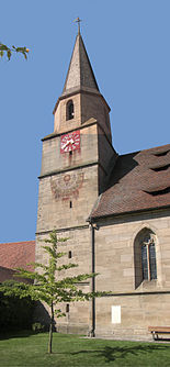
Veal Steinberger Church , also Caskets franc called
|
|
Kalbensteinberg is a district of the Absberg market in the Weissenburg-Gunzenhausen district in Central Franconia .
geography
The parish village is located in the north of the Weißenburg-Gunzenhausen district in the Franconian Lake District , about four kilometers northwest of Absberg, at an altitude of 489 m above sea level. NN . The Igelsbach rises south of the village . Several tributaries of the Erlbach have their source in the vicinity . Kalbensteinberg is close to the border with the neighboring community of Haundorf and the district of Roth . The district roads WUG 22 and WUG 21 lead through the village . The Reckenberg rises southwest of the village . The place is in the Spalter hill country .
history
Kalbensteinberg was first mentioned in a document in 1247; a mention from 1194 is to be assigned to the neighboring village of Gräfensteinberg. The source of the early history is mostly in the dark. As a dowry from the Abenberger Diemutha, part of the village came into the possession of the Roggenburg Monastery near Neu-Ulm. In 1412 the monastery sold its property to the Counts of Oettingen . In the same year, the former Roggenburg properties came from the Stromer and Wernitzer families to the Rieter von Kornburg family in 1437 , who held all the properties as landlords from around 1600 until they died out in 1753. Through the Rieterstiftung, Kalbensteinberg fell to the Heilig-Geist-Spital and thus to the imperial city of Nuremberg . After the transition to the Kingdom of Prussia in 1791, Kalbensteinberg was integrated into the newly founded Kingdom of Bavaria in 1806 with the areas of the Principality of Ansbach .
In the course of the municipal reform , the formerly independent Kalbensteinberg with its district Igelsbach was incorporated into the Absberg market on May 1, 1978.
Culture and sights
Numerous buildings in the place are included in the list of architectural monuments .
Kalbensteinberg is part of the Spalter hop growing area . The place is best known for its fruit growing. The cherry blossom at the end of April is worth seeing with its climax, the cherry blossom festival on May 1st. The cherry picking takes place in the village in mid-July. The Kirschhoff Festival is celebrated annually during this time. The fruit and horticultural association has its own distillery cooperative .
In 1995 the place won a prize in the competition Our village should become more beautiful . One of the historic St. James' paths for pilgrims in the direction of Santiago de Compostela leads through Kalbensteinberg .
The Rieter Church was built from 1464 (completion 1488). A fundamental redesign took place around 1610, which has shaped the church furnishings to this day.
Soil monuments
See: List of soil monuments in Absberg
traffic
The federal highway 466 , which connects Gunzenhausen with Schwabach , runs two kilometers west of the village.
Personalities
- Michael Jäger (1876–1962), farmer, mayor (1933–1945) and member of the NSDAP in the Bavarian state parliament
Individual evidence
- ^ Federal Statistical Office (ed.): Historical municipality directory for the Federal Republic of Germany. Name, border and key number changes in municipalities, counties and administrative districts from May 27, 1970 to December 31, 1982 . W. Kohlhammer GmbH, Stuttgart / Mainz 1983, ISBN 3-17-003263-1 , p. 730 .


