
Theilenhofen
| coat of arms | Germany map | |
|---|---|---|

|
Coordinates: 49 ° 5 ' N , 10 ° 51' E |
|
| Basic data | ||
| State : | Bavaria | |
| Administrative region : | Middle Franconia | |
| County : | Weissenburg-Gunzenhausen | |
| Management Community : | Gunzenhausen | |
| Height : | 494 m above sea level NHN | |
| Area : | 20.33 km 2 | |
| Residents: | 1119 (Dec. 31, 2019) | |
| Population density : | 55 inhabitants per km 2 | |
| Postal code : | 91741 | |
| Area code : | 09834 | |
| License plate : | WUG, GUN | |
| Community key : | 09 5 77 172 | |
| Community structure: | 5 parts of the community | |
| Association administration address: | Frankenmuther Str.2d 91710 Gunzenhausen |
|
| Website : | ||
| Mayor : | Helmut König | |
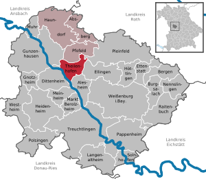
| Location of the community of Theilenhofen in the district of Weißenburg-Gunzenhausen | ||
  |
||

.jpg)
Theilenhofen is a municipality in the central Franconian district of Weißenburg-Gunzenhausen and a member of the Gunzenhausen administrative community .
geography
location
Theilenhofen is located in the West Central Franconia region , around 44 kilometers as the crow flies south of Nuremberg and around ten kilometers west of Weißenburg in Bavaria as the crow flies . The municipality is shaped like a triangle running south. The Altmühl , on which the district of Gundelsheim is located, forms the western border of the municipality. The Dornhauser Mühlbach , the Wachsteiner Bach and (via an alluvial ditch from this) the Weidachgraben flow into the Altmühl in the municipality . The Knöpfelbach rises near Theilenhofen . The federal road 13 runs through Theilenhofen , in ancient times the Limes ran through the northern municipal area. The community is mainly located in a wide open landscape, characterized by meadows and fields.
Neighboring communities
The neighboring communities are:
| Gunzenhausen | Pfofeld , Gunzenhausen | Pleinfeld |
| Dittenheim |
.svg)
|
Ellingen |
| Dittenheim | Dittenheim , Alesheim , | Alesheim |
Community structure
The municipality has 5 officially named municipal parts (the type of place and the number of inhabitants are given in brackets ):
- Dornhausen ( Pfarrdorf , 263)
- Gundelsheim an der Altmühl (Pfarrdorf, 199)
- Knights ( village , 83)
- Theilenhofen (Pfarrdorf, 446)
- Wachstein (parish village, 202)
history
Until the church is planted
Theilenhofen was first mentioned in the 13th century. The place was in the Deutschordensballei Franconia , which was part of the Franconian Empire from 1500 . In 1796 Prussia sequestered the rights of the Teutonic Order (village and community rulership by the Land Commissioner Ellingen ). In the Treaty of Paris (February 1806), Theilenhofen fell to the Prussian Principality of Ansbach by swap to the Kingdom of Bavaria . In the course of the administrative reforms in Bavaria, the municipality was created with the municipal edict of 1818 .
Incorporations
On May 1, 1978, the previously independent municipalities of Dornhausen, Gundelsheim an der Altmühl and Wachstein were incorporated.
Population development
- 1961: 962 inhabitants
- 1970: 932 inhabitants
- 1987: 1008 inhabitants
- 1991: 1065 inhabitants
- 1995: 1134 inhabitants
- 2000: 1181 inhabitants
- 2005: 1200 inhabitants
- 2010: 1189 inhabitants
- 2015: 1129 inhabitants
politics
mayor
Mayor is currently Helmut König.
coat of arms
The description of the coat of arms reads: In black on a golden floor, a silver draw well with trough and bucket.
Culture and sights


Traces of the Limes can be found in Theilenhofen . The floor plan of the former Roman fort Iciniacum is indicated in the corridor "Die Weil" by paths and tree planting. 250 meters west of it, visitors are introduced to the history of the ancient site through an information board near the foundation walls of the associated military bath.
The baroque St. Agatha Church is located in the village .
Architectural monuments
Economy and Infrastructure
Economy including agriculture and forestry
In 1998, according to official statistics, there were no employees at the place of work in the manufacturing sector 106 or in the trade and transport sector. There were a total of 377 employees at the place of residence subject to social security contributions. There was one company in the manufacturing sector and four companies in the main construction sector. In addition, there were 68 farms in 1999 with an agriculturally used area of 1751 hectares, of which 1165 hectares were arable land and 586 hectares were permanent green space.
traffic
The federal highway 13 and the district road WUG 2 run through Theilenhofen . The next motorway connection is the Lichtenau junction of federal motorway 6 at a distance of around 32 kilometers. The next rail connection is around 10 kilometers away with Gunzenhausen station on the Treuchtlingen – Würzburg railway line . Local public transport is ensured by the transport association for the greater Nuremberg area .
Long-distance cycle routes
The German Limes Cycle Route runs through the community . It follows the Upper German-Raetian Limes over 818 km from Bad Hönningen on the Rhine to Regensburg on the Danube .
education
The following institutions exist (as of 1999):
- Kindergartens: 75 kindergarten places with 62 children
- Primary schools: with 14 teachers and 206 students
Theilenhofen is a member of the Pfofeld- Theilenhofen school association in the elementary school sector and the Absberg - Haundorf elementary school association in the middle school sector .
literature
- Johann Kaspar Bundschuh : Theilenhofen . In: Geographical Statistical-Topographical Lexicon of Franconia . tape 5 : S-U . Verlag der Stettinische Buchhandlung, Ulm 1802, DNB 790364328 , OCLC 833753112 , Sp. 519-520 ( digitized version ).
- Gottfried Stieber: Theilenhofen . In: Historical and topographical news from the Principality of Brandenburg-Onolzbach . Johann Jacob Enderes, Schwabach 1761, p. 807-808 ( digitized version ).
- Pleikard Joseph Stumpf : Theilenhofen . In: Bavaria: a geographical-statistical-historical handbook of the kingdom; for the Bavarian people . Second part. Munich 1853, p. 722-723 ( digitized version ).
Web links
- Entry on the coat of arms of Theilenhofen in the database of the House of Bavarian History
Individual evidence
- ↑ "Data 2" sheet, Statistical Report A1200C 202041 Population of the municipalities, districts and administrative districts 1st quarter 2020 (population based on the 2011 census) ( help ).
- ↑ In BayernViewer discretion; Reference point: southern city center of Nuremberg
- ↑ Theilenhofen community in the local database of the Bavarian State Library Online . Bayerische Staatsbibliothek, accessed on December 25, 2019.
- ^ History of Theilenhofen
- ↑ a b c Federal Statistical Office (ed.): Historical municipality directory for the Federal Republic of Germany. Name, border and key number changes in municipalities, counties and administrative districts from May 27, 1970 to December 31, 1982 . W. Kohlhammer, Stuttgart / Mainz 1983, ISBN 3-17-003263-1 , p. 730 .
- ^ Primary school - Theilenhofen community
- ^ Middle school - Theilenhofen community

Absberg | Alesheim | Mountains | Burgsalach | Dittenheim | Ellingen | Ettenstatt | Gnotzheim | Gunzenhausen | Haundorf | Heidenheim | Höttingen | Langenaltheim | Berolzheim market | Meinheim | Muhr am See | Nennslingen | Pappenheim | Pfofeld | Pleinfeld | Polsingen | Raitenbuch | Solnhofen | Theilenhofen | Treuchtlingen | Weißenburg in Bavaria | Westheim