
Westheim (Weißenburg-Gunzenhausen)
| coat of arms | Germany map | |
|---|---|---|

|
Coordinates: 49 ° 0 ' N , 10 ° 40' E |
|
| Basic data | ||
| State : | Bavaria | |
| Administrative region : | Middle Franconia | |
| County : | Weissenburg-Gunzenhausen | |
| Management Community : | Cockscomb | |
| Height : | 439 m above sea level NHN | |
| Area : | 28.32 km 2 | |
| Residents: | 1169 (Dec. 31, 2019) | |
| Population density : | 41 inhabitants per km 2 | |
| Postal code : | 91747 | |
| Primaries : | 09082, 09833 | |
| License plate : | WUG, GUN | |
| Community key : | 09 5 77 179 | |
| Community structure: | 5 parts of the community | |
| Association administration address: | Ringstrasse 12 91719 Heidenheim, Germany |
|
| Website : | ||
| Mayor : | Herbert Weigel ( community of voters ) | |
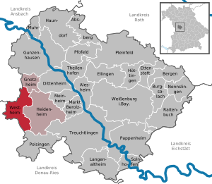
| Location of the community of Westheim in the Weißenburg-Gunzenhausen district | ||
  |
||

_001.jpg)

Westheim is a municipality in the central Franconian district of Weißenburg-Gunzenhausen and a member of the Hahnenkamm administrative community based in Heidenheim .
geography
location
Westheim is located in the west of the Weißenburg-Gunzenhausen district in the West Central Franconia region , around 14 kilometers as the crow flies southwest of Gunzenhausen and near the Hahnenkamm low mountain range , a range of mountains in the Franconian Alb . Larger places nearby are Wassertrüdingen (6 km) and Oettingen (7 km). The Bruckbach , a tributary of the Wörnitz , flows through the place. Another body of water in the area of the municipality is the Lothbach , especially in the north there are numerous ditches and small streams. To the southwest is the Auwald nature reserve near Westheim . The westernmost point of the Weißenburg-Gunzenhausen district is located in the alluvial forest. Westheim is located directly on the 49th parallel.
Neighboring communities
The neighboring communities are:
| Wassertrüdingen | Gnotzheim , Wassertrüdingen | Heidenheim |
| Wassertrüdingen , Auhausen , Hainsfarth |
.svg)
|
Heidenheim |
| Hainsfarth | Hainsfarth , Polsingen , | Heidenheim |
Community structure
The municipality has 5 officially named municipal parts (the type of place is given in brackets ):
- Hüssingen ( parish village )
- Ostheim (parish village)
- Pagenhard ( hamlet )
- Roßmeiersdorf ( village )
- Westheim (parish village)
history

Until the church is planted
In the "Mehlbuck" one of three early Merovingian burial grounds within the Westheim district was discovered. It is often considered the earliest proof of francs in Middle Franconia. The grave field was certainly not directly related to the present-day town of Westheim, but to a settlement in the area of the higher ground above the river valley, where the two old Roman roads Geilsheim - Hüssingen and Gunzenhausen- Nördlingen crossed. The originally more than 250 graves contain burials for men, women and children as well as two horse burials. The burial ground was used at the latest from the beginning of the 6th century (around 520-530) until at least the second half of the 7th century. Subsequently, the place seems to have fallen in desolation, before the addition custom ends in southern Germany . The high number of typically Franconian weapons, such as Franziska and Ango , as well as the nine coin graves is striking. These included three Roman denarii from the 3rd century and five Gothic semi- siliques by Athalaric , Witiges and Totila , which were presumably used as Charon pennies .
Furthermore, the remains of a small early medieval church were discovered on the outskirts of Westheim . It was built around the year 600 and, together with the Sola basilica in Solnhofen, is one of the oldest churches in the region. In the meantime, a reconstruction of the church has been built and can be visited. The settlement to which the burial ground may have belonged was once located around the church. With the establishment of a royal court in Westheim, however, the older settlement lost its importance and was finally given up in favor of the settlement around the church of St. Pankratius .
Westheim belonged to the Principality of Ansbach acquired by Prussia in 1792 , which from 1500 belonged to the Franconian Empire . With the Rhine Confederation Act 1806, the place came to the Kingdom of Bavaria . In the course of the administrative reforms in Bavaria, today's municipality was created with the municipal edict of 1818 .
Incorporations
On May 1, 1978, the previously independent communities of Hüssingen and Ostheim were incorporated.
Population development
- Westheim village
- 1910: 661 inhabitants
- 1933: 631 inhabitants
- 1939: 572 inhabitants
- 1961: 625 inhabitants
- 1970: 594 inhabitants
- 2008: 978 inhabitants
- Westheim municipality (today's municipality)
- 1961: 1339 inhabitants
- 1970: 1246 inhabitants
- 1987: 1208 inhabitants
- 1991: 1243 inhabitants
- 1995: 1254 inhabitants
- 2000: 1230 inhabitants
- 2005: 1189 inhabitants
- 2010: 1152 inhabitants
- 2015: 1141 inhabitants
politics
The municipal council has twelve members. They are distributed among the individual voter communities as follows :
| Party / list | Share of votes | Seats |
| Westheim voter community | 43.2% | 5 |
| Hüssingen voter community | 25.1% | 3 |
| Ostheimer applicants | 31.7% | 4th |
The turnout was 81.3%.
| Party / list | Share of votes | Seats |
|---|---|---|
| Westheim voter community | 46.8% | 6th |
| Hüssingen voter community | 25.0% | 3 |
| Ostheimer applicants | 28.2% | 3 |
The turnout was 79.1%.
| mayor | Election year | Voting share |
|---|---|---|
| Herbert Weigel | 2020 | 59.7% |
| Helmut Schindler | 2014 | |
| Günther Oberhauser | before 2015 |
In 2020 Herbert Weigel, formerly 2nd mayor, was elected mayor with 59.7% of the vote.
coat of arms
The municipality of Westheim has had its own coat of arms since July 26, 1965.
_COA.svg) |
Blazon : "A standing, silver-clad farmer in black, holding a silver sword in his right hand pointing downwards, and in his left hand pointing upwards a silver flag with a red collar." |
| Reasons for the coat of arms: The farmer with the Bundschuh flag is reminiscent of the Peasants' War of 1525 and emphasizes the role of Westheim as the center of the uprising. A peasant captain came from Westheim who fought against the margraves' troops. The colors silver and black indicate that it once belonged to the Principality of Ansbach . |
Architectural monuments
Economy and Infrastructure
Economy including agriculture and forestry
The municipal tax revenue amounted to the equivalent of 548,000 euros in 1999, of which the equivalent of 99,000 euros (net) was trade tax revenue.
In 1998, according to official statistics, there were no employees at the place of work in the manufacturing sector 111 or in the trade and transport sector. In other economic areas, 233 people were employed at the place of work subject to social security contributions. There were a total of 420 employees at the place of residence subject to social insurance contributions. There was one company each in manufacturing and construction. In addition, there were 72 agricultural holdings in 1999 with an agricultural area of 1742 hectares, of which 1174 hectares were arable land and 568 hectares were permanent green space.
traffic
Westheim is crossed by the federal highway 466 from Gunzenhausen to Nördlingen. The district road WUG 30 leads to Hüssingen, a municipal road to Auhausen .
education
In 1999 there were 50 kindergarten places with 51 children.
Personalities
- Johann Christoph Schuster (1759–1823), watchmaker and calculating machine designer
- Gustav Baist (1824–1914), Protestant pastor, founder of several Raiffeisenkassen in Middle Franconia
- Therese Stählin (1839–1928), superior of the Neuendettelsau deaconess institution
- Georg Bachmann (1885–1971), politician, member of the Reichstag, President of the Bavarian Raiffeisen Association
- Wilhelm Bachmann (1895–1969), CSU politician
- Rudolf Bachmann (1925–1998), politician of the CSU
literature
- Johann Kaspar Bundschuh : Westheim . In: Geographical Statistical-Topographical Lexicon of Franconia . tape 6 : V-Z . Verlag der Stettinische Buchhandlung, Ulm 1804, DNB 790364328 , OCLC 833753116 , Sp. 202 ( digitized version ).
- Gottfried Stieber: Westheim . In: Historical and topographical news from the Principality of Brandenburg-Onolzbach . Johann Jacob Enderes, Schwabach 1761, p. 941-944 ( digitized version ).
Web links
- Entry on the coat of arms of Westheim (Weißenburg-Gunzenhausen) in the database of the House of Bavarian History
Individual evidence
- ↑ "Data 2" sheet, Statistical Report A1200C 202041 Population of the municipalities, districts and administrative districts 1st quarter 2020 (population based on the 2011 census) ( help ).
- ^ Community Westheim in the local database of the Bavarian State Library Online . Bayerische Staatsbibliothek, accessed on December 25, 2019.
- ^ Andreas Kraus: History of Franconia up to the end of the 18th century. Vol. 3/1. Series: Handbuch der Bayerischen Geschichte, complete works in 4 volumes: Handbuch der Bayerischen Geschichte, 4 volumes in 6 Tl.-Bdn., CH Beck, 3rd, neubearb. A. (1997). (P. 58 ff.)
- ↑ Westheim early medieval church on the website www.fraenkisches-seenland.de
- ↑ a b c d e Federal Statistical Office (Hrsg.): Historical municipality register for the Federal Republic of Germany. Name, border and key number changes in municipalities, counties and administrative districts from May 27, 1970 to December 31, 1982 . W. Kohlhammer, Stuttgart / Mainz 1983, ISBN 3-17-003263-1 , p. 731 .
- ↑ Municipal directory Germany 1900 - Kingdom of Bavaria - District Middle Franconia - District Office Gunzenhausen. On: gemeindeververzeichnis.de
- ^ Michael Rademacher: German administrative history from the unification of the empire in 1871 to the reunification in 1990. Gunzenhausen district. (Online material for the dissertation, Osnabrück 2006).
- ^ Bavarian State Office for Statistics , accessed on July 30, 2017
- ↑ Results. Retrieved June 9, 2020 .
- ↑ Mayoral election. Retrieved June 9, 2020 .
- ^ Entry on the coat of arms of Westheim (Weißenburg-Gunzenhausen) in the database of the House of Bavarian History

Absberg | Alesheim | Mountains | Burgsalach | Dittenheim | Ellingen | Ettenstatt | Gnotzheim | Gunzenhausen | Haundorf | Heidenheim | Höttingen | Langenaltheim | Berolzheim market | Meinheim | Muhr am See | Nennslingen | Pappenheim | Pfofeld | Pleinfeld | Polsingen | Raitenbuch | Solnhofen | Theilenhofen | Treuchtlingen | Weißenburg in Bavaria | Westheim