
Lorraine
|
Lorraine Former French Region (until 2015) |
|

|

|
  |
|
| Basic data | |
|---|---|
| Today part of | Grand Est |
| Administrative headquarters | Metz |
|
population
- total January 1, 2018 |
2,328,460 inhabitants |
|
surface - total |
23,547 km² |
| Departments | 4th |
| Arrondissements | 19th |
| Cantons | 157 |
| Municipalities | 2,338 |
| Formerly ISO 3166-2 code | FR-M |
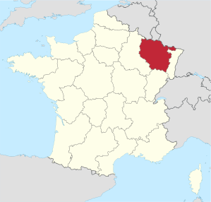
Lorraine ( French Lorraine [ lɔˈʀɛn ]) is a landscape in north-eastern France . It is the central part of the Grand Est region . From 1960 to the end of 2015, Lorraine, which goes back to the historic Duchy of Lorraine , formed a separate region with the capital Metz , consisting of the departments Meurthe-et-Moselle , Meuse , Moselle and Vosges (and Haute-Marnefor the cultural region). Lorraine, which continues to be defined in this way, has an area of 23,547 km² and 2,328,460 inhabitants (as of January 1, 2018).
German domestic usage, the term refers to historic Lorraine sometimes only the 1871-1918 to the German Reich belonging District Lorraine or the existing 1940 to 1945 CdZ area Lorraine , both today Moselle included.
geography

Lorraine is located in north-eastern France on the upper reaches of the Meuse (French Meuse ), Moselle ( Moselle ), Saar ( Sarre ) and Saône . It forms the eastern branch of the Paris basin . The eastern border is formed by the Vosges . The highest point is the Hohneck at 1364 meters. Lorraine borders in the north on the Belgian province of Luxembourg , the Grand Duchy of Luxembourg and the German federal states of Saarland and Rhineland-Palatinate . With these bordering areas, Lorraine forms a major European region as well as the Saar-Lor-Lux European region around the border triangle . In the east, Lorraine borders on Alsace and in the south on the Bourgogne-Franche-Comté region . To the west is the Champagne .
coat of arms

Duchy of Lorraine ( Scheibler's book of arms , around 1470)

Coat of arms of the Duke of Lorraine, around 1700
Duchy of Lorraine ( Hugo Gerard Ströhl , 1890)

Flag of Lorraine


.jpg)
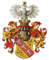
The Lorraine coat of arms shows a red diagonal right bar in gold , which is covered with three silver Alérion (mutilated eagles). It goes back to the coat of arms of the Duchy of Lorraine . The sloping beam with the eagles appears in the seals of Duke Simon II (Lorraine) around 1195 . The mutilation of eagles did not appear until the 15th century. The motif is also included in the Saarland's coat of arms .
Lorraine cross
The Lorraine Cross (Croix de Lorraine) was the symbol of the younger house of Anjou , who ruled Lorraine from 1431 to 1473. It was best known as a symbol of free France and the French government in exile under Charles de Gaulle and their military associations. In 1972 the Lorraine cross was chosen as the motif for the memorial to Charles de Gaulle in Colombey-les-Deux-Églises ( Haute-Marne department ).

Lorraine cross in the corner of the flag of Alsace-Lorraine from 1912/1918

Flag of the Forces françaises libres in World War II
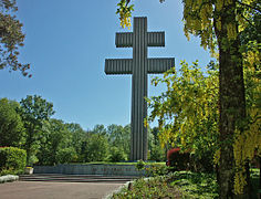
Lorraine cross as a monument to de Gaulle in Colombey-les-Deux-Églises
.svg)
.svg)

history
Roman province of Belgica (1st century BC to 5th century AD)
The area around the Moselle, which is predominantly populated by Celtic tribes, was established between 58 and 51 BC. Conquered by Gaius Iulius Caesar in the Gallic War and later part of the Roman province of Gallia Belgica . In late antiquity, during the administrative reform of Emperor Diocletian in AD 295, the Gallia Belgica was reorganized into the provinces of Belgica I in the south and Belgica II in the north. The Belgica I (Belgica Prima) already roughly corresponded to the area of the present-day Lorraine region, but also included part of the lower course of the Moselle with the important metropolis of Augusta Treverorum (the Roman Trier ). Important Lorraine cities such as Metz (Divodurum) or Verdun (Virodunum) have their origins in Roman times. The area was shaped by the Gallo-Roman culture , Moselle -Roman language islands even survived the migration period up to the beginning of the High Middle Ages. At the same time also Germanic settlers many of whom lived in the province, laeti in the Roman army. In the transition period from late antiquity to the early Middle Ages , the area initially fell under the rule of the Alemanni and then became part of the Franconian Empire in the 5th century .

The late antique province of Belgica I
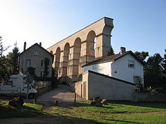
Ruins of a Roman aqueduct in Jouy-aux-Arches

.jpg)

Lotharingia and Duchy of Lorraine (843–1766)

From a tripartite division of the Franconian Empire , the Lotharii Regnum emerged in 843 , the "Empire of Lothar" or Lotharingien named after its king . It lay in the middle between the East and West Franconian Empire and originally stretched as an elongated territory from the Mediterranean to the North Sea. In 870 the area was again divided between the East and West Franconian Empire. However, the name Lotharingien was retained in the Reichsverband, whereby a distinction was initially made between the Upper Lorraine, through which the Moselle flowed, and the Lower Lorraine to the north . While Lower Lorraine soon split up into several principalities in the Middle Ages, the Duchy of Lorraine continued to exist in the Upper Lorraine region, which was part of the Holy Roman Empire until 1766 . Lorraine then became a province of the Kingdom of France , which had annexed Alsace in the previous century .
The Lorraine region , which existed from 1960 to 2015, comprised the core area of historic Upper Lorraine.
industrialization
Industrialization began in the Nancy region around 1850 . The Nancy – Metz railway line was opened in 1850, and the continuous railway line from Reims via Nancy to Strasbourg and from Metz via Saarbrücken to Mannheim in 1851/52 . France began to build a Moselle canal between Frouard and Metz from 1867 to connect Lorraine with the French canal network. A usable canalization of the Moselle did not take place until the years 1858 to 1879. From the second half of the 19th century, the mining of coal from the Saarland-Lorraine deposits began, albeit to a lesser extent than in the neighboring Saar region. In 1858 Napoleon III announced. officially the discovery of the coal basin in Lorraine, seven shafts were built by 1867.
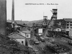
Mine in Creutzwald- la-Croix
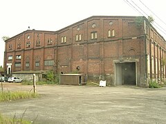
Mine in L'Hôpital (Spittel)
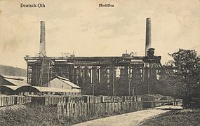
Steel mill in Audun-le-Tiche (German-Oth)

Ore loading building in Neuves-Maisons


Division of Lorraine (1871-1918)


.svg)
After the victory of Prussia and its allies in the Franco-Prussian War in 1871, the areas with a predominantly German-speaking population in the north-east of Lorraine were merged as the District of Lorraine together with Alsace to form the realm of Alsace-Lorraine and incorporated into the newly founded German Empire . The border line in Lorraine included the French-speaking area to a large extent, in particular the city of Metz and its surrounding area. The newly created Reichsland - unlike the other German member states - initially had no independence and was directly subordinate to the German Kaiser . With Alsace and the north-eastern part of Lorraine, two countries were connected, each with its own regional identity. While Alsace belonged to the Alemannic cultural area, the German-speaking part of Lorraine was part of the Franconian cultural area. An annexation of Lorraine to the Palatinate (Bavaria) and of Alsace to the Grand Duchy of Baden , which had taken this cultural proximity into account, was rejected again.
The greater part of Lorraine remained on the French side in 1871. Because of the new demarcation, a new department was set up: The Meurthe department, which remained largely in France, with the capital Nancy was merged with the western part of the former Moselle department to form the Meurthe-et-Moselle department .
The industrialization of the region continued and in the following period a powerful heavy industry developed on both sides of the border in the area of Metz , Diedenhofen and Nancy .
In 1893 the Marne-Rhine Canal was opened from Reims via Nancy and the Zaberner Steige to Strasbourg.
First World War
From 1914 to 1918, Lorraine was one of the main combat areas on the Western Front (First World War) . The Battle of Lorraine took place here in 1914 and the Battle of Verdun in 1916 . After the German defeat in 1918, the north-eastern part of Lorraine was again separated from the German Empire by the Peace Treaty of Versailles and annexed to France as the Moselle department . After that, the French language was legally the sole official and school language, also for the German-speaking population.
Second World War
During the Second World War , Lorraine was occupied by Wehrmacht troops in June 1940 ( western campaign ) . After the capitulation of France , the Moselle department, as the Lorraine CdZ area , was subordinated to a head of civil administration (CdZ), the NSDAP politician Josef Bürckel , and was effectively treated as territory of the Reich. The German language was again prescribed as the official and school language . A considerable part of the non-German-speaking population was expelled, up to October 1943, according to contemporary data, about 80,000 people, which corresponded to 15 percent of the population.
The area was later to form the Reichsgau Westmark together with the Saarland and the Palatinate . Saarbrücken was planned as the capital , where the head of civil administration already had his seat. The area was no longer formally incorporated into the German Empire.
Lorraine and Alsace were retaken by Allied forces in November and December 1944 and once again became part of France. The French language became the sole official and school language again - also for the German-speaking population.
Region (1960–2015)

The Lorraine region was created in 1960 with the establishment of the regions in France. In 1972 the region received the status of an établissement public under the direction of a regional prefect. The decentralization laws of 1982 gave the regions the status of collectivités territoriales ( local authorities ), which until then had only been possessed by the municipalities and the départements . In 1986 the regional councils were elected directly for the first time. Since then, the region's powers vis-à-vis the central government in Paris have been gradually expanded. On January 1, 2016, the Lorraine region was merged with the neighboring regions of Champagne-Ardenne and Alsace to form the Grand Est region .
population
languages
The southern, central and western parts of Lorraine belong to the French , the north-eastern parts of Lorraine to the German- speaking area. The French language, which at the time was prescribed by France as the official and school language for the German-Lorraine population in northeast Lorraine, has now largely replaced the German language ( Middle Franconian dialects). In some (rural) areas, however, the German dialects ( Lorraine , Moselle Franconian and Rhine Franconian ) are still spoken - mainly by the older generation .
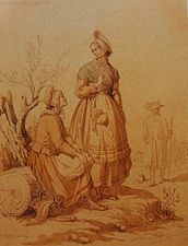
Lorraine traditional clothing of the 19th century
With the end of the 19th century and the boom in industry, rural traditional clothing died out in Lorraine. The Trier-born artist August Migette (1802 in Trier - 1884 in Metz ) handed down the traditional clothing in the region in his watercolor studies from May 1866, which are now kept in the Metz city museum (Musées de Metz).
- Traditional costume clothing of the 19th century, traditional costume sketches by August Migette, 1866


.jpg)
.jpg)
.jpg)
.jpg)
.jpg)
.jpg)
Men
The men wore linen shirts with high collars that peeked out from a black silk necktie tied several times around their necks. The usual before the French Revolution culotte trousers of the men were gradually replaced in the 19th century by the long pantaloon pants. Some of these pants had rows of buttons on the side of the calves. Low buckled shoes were worn with shorts. On ordinary Sundays one wore a dark blue or gray blouse when going to church, which was complemented by a long dark-colored frock coat (tailcoat, chasse, check, anglaise) on high church holidays, weddings and funerals. As headgear, the man wore a white-ground pointed cap with a blouse, which was interwoven with blue and red yarn. The matching headgear for the frock coat was a large, broad-brimmed hat. The faces were beardless and clean-shaven.
Women
A finely folded collar framed the neck. The upper body was not formed by a corset, but by a sleeveless, tightly fitting camisole with a hip bulge. On weekdays a triangular folded square scarf was worn over the bodice, which was pinned together over the chest. The two corners of the cloth were tucked under the apron band and held by the apron band. The holiday aprons were made of silk. A silver or gold cross, which was usually attached to a black collar, was worn as a necklace. Wealthy women wore a gold link chain instead of the black ribbon. The necklace was sometimes supplemented with gold earrings. The hair was parted in the middle, combed tightly and pinned at the back of the head. The Lorraine woman wore a padded and quilted hood over it. In German Lorraine, the plate-like back of the head part of the hood was higher than in the French-speaking part of the country. The predominant color was white, although black was also found. On public holidays, a finely knitted cap or "fog cap" was often pulled over this hood. Based on the unpadded “Bonnet à la reine” worn by Queen Marie-Antoinette, the old Lorraine bonnet was gradually displaced. When working in the fields and in the garden in summer, the women also wore straw hats.
On holidays, a short jacket was also worn over the bodice. The waistband of the skirt rested on the hip bulge of the bodice in order to create a bell shape rich in folds and fabric. The holiday skirts were mostly made of fine silk in subtle colors. The skirts left the feet exposed. The artfully knitted stockings in white, gray or blue basic color were embroidered in bright colors in the visible area between the shoe and the hem of the skirt. The heel of the women's heelless shoes was low. The shoe was held with a small strap above the instep.
Cities
The most populous cities in Lorraine are:
| city | Inhabitants (year) | Department |
|---|---|---|
| Metz | 116,581 (2018) | Moselle |
| Nancy | 104,885 (2018) | Meurthe-et-Moselle |
| Thionville | 40,477 (2018) | Moselle |
| Epinal | 32,223 (2018) | Vosges |
| Vandœuvre-lès-Nancy | 30,009 (2018) | Meurthe-et-Moselle |
| Montigny-lès-Metz | 21,749 (2018) | Moselle |
| Sarreguemines | 20,820 (2018) | Moselle |
| Forbach | 21,652 (2018) | Moselle |
| Saint-Dié-des-Vosges | 19,724 (2018) | Vosges |
| Luneville | 18,027 (2018) | Meurthe-et-Moselle |
Political organization (1960–2015)
The Lorraine region was divided into four departments :
| Department | prefecture | ISO 3166-2 |
Districts | Cantons | Municipalities | Population as of 2018 |
Area in km² |
Population / km² |
|---|---|---|---|---|---|---|---|---|
| Meurthe-et-Moselle | Nancy | FR-54 | 4th | 44 | 594 | 733.469 | 5,246 | 139.8 |
| Meuse | Bar-le-Duc | FR-55 | 3 | 31 | 500 | 185.355 | 6.211 | 29.8 |
| Moselle | Metz | FR-57 | 9 | 51 | 730 | 1,043,524 | 6.216 | 167.9 |
| Vosges | Epinal | FR-88 | 3 | 31 | 514 | 366.112 | 5,874 | 62.3 |
| total | 19th | 157 | 2,338 | 2,328,460 | 23,547 | 98.9 | ||
economy
Lorraine contributes 3.4% of the French GDP (40.4 billion euros). In comparison with the GDP of the European Union expressed in purchasing power standards , the region achieved an index of 89.0 in 2006 (EU-27 = 100).
The economy focuses on the service sector, followed by industry. The coal and steel industry has lost its former importance. In the area around Thionville and Hayange in particular , this structural change in the last decades away from steel and the disappearance of the Lorraine mines has led to high unemployment , which so far could not be offset by the establishment of new industries. As a result, the region that was once an industrial center has become one of the economically weakest and poorest in France. Trémery is home to the world's largest production facility for diesel engines . Another location of the automotive industry is Smartville Hambach .
Wine regions are located at the Moselle in the landscapes Côtes de Moselle in Metz and Sierck-les-Bains and in the de Cotes Toul in the same city Toul , also on the Seille and on the upper Maas . The second largest French brewery, Brasserie Champigneulles, is located in Lorraine.
education
Universities
There are several universities in Lorraine, including three universities in Nancy and one in Metz . These have several branch offices in smaller towns in Lorraine. There are also several Grandes Écoles in Lorraine. In particular , some of the engineering colleges grouped together in the Institut National Polytechnique de Lorraine enjoy an excellent reputation in France.
Language lessons
Language teaching at the schools in Lorraine now takes account of the history and geographic location on the language border. Since 1976, German has been taught in the Moselle department in the voie spécifique mosellane program in primary school ( École maternelle ). The offer includes three-hour normal language lessons or six or nine-hour bilingual lessons . In the immediate vicinity of the border, individual schools even offer language lessons in equal parts - 13 hours each in German and French. The authorities are trying to use native German teachers - also from neighboring Saarland - for this purpose .
Today, 30 percent of students in Lorraine choose German as their first foreign language. 26 percent start taking German lessons in elementary school at the latest. This means that German has a significantly stronger position in Lorraine schools than English compared to the French average. In almost 100 secondary schools ( colleges and lycées ), increased or bilingual German lessons are offered. At selected schools - usually close to the border with Germany - it is possible to acquire the German Abitur at the same time as the French Baccalauréat .
The partner on the German side of the more extensive teaching measures is usually the federal state of Saarland , where conversely - compared to the national average - there is significantly more support for the French language in schools.
A promotion of the original Lorraine German dialects does not take place at the schools, contrary to the demands of corresponding associations and regional parties.
Culture
Culinary specialties
- Dragées from Verdun
- Gâteau au chocolat , chocolate cake
- La Duchesse from Bar-le-Duc, seedless currant jam
- Macarons from Nancy and Bolchen, almond macaroons
- Madeleines from Commercy, a shell-shaped biscuit
- Mirabelle plums, among others. as jam and eau de vie
- Potée Lorraine , a hearty stew with cabbage, various vegetables and sausages
- Quiche Lorraine , a salty shortcrust cake with bacon
Nature parks
- Ballons des Vosges Regional Nature Park (French: Parc naturel régional des Ballons des Vosges )
- Lorraine Regional Nature Park ( French Parc naturel régional de Lorraine )
-
Regional Nature Park Vosges du Nord (French: Parc naturel régional des Vosges du Nord )
It was merged in 1998 with the immediately adjacent Palatinate Forest Nature Park in Germany under the auspices of UNESCO to form the cross-border Biosphere Reserve Palatinate Forest-Vosges du Nord .
Sports
The FC Metz and AS Nancy play in Ligue 1 , the highest league in French football. AS Nancy won the Coupe de la Ligue in 2006 . In the 2006/07 season this reached the round of 32 in the UEFA Cup . Most of the clubs in the Moselle department have their roots in previous German clubs. FC Metz, for example, emerged from a merger of several Metz clubs.
Personalities
- Joan of Arc (* 1412 in Domrémy , † 1431 in Rouen ), French national heroine
- Ligier Richier (* around 1500 in Saint-Mihiel ; † 1567 in Geneva ), sculptor
- Louise de Lorraine-Vaudémont (* 1553 in Nomeny ; † 1601 in Moulins ), wife of Henry III., Queen of France from 1575 to 1589
- Jacques Callot (* 1592 in Nancy; † 1635 ibid), draftsman and graphic artist
- Georges de la Tour (* 1593 in Vic-sur-Seille , † 1652 in Lunéville ), painter

- Claude Gellée, also Claude Lorrain (* 1600 in Chamagne , † 1682 in Rome ), painter
- Franz Stephan von Lothringen (* 1708 in Nancy, † 1765 in Innsbruck ), as Franz I Emperor of the Holy Roman Empire
- Nicolas Gilbert (* 1750 in Fontenoy-le-Château ; † 1780 in Paris), poet
- Nicolas Chopin (* 1771 in Marainville-sur-Madon , † 1844 in Warsaw ), French-Polish language teacher, father of Frédéric Chopin
- Paul Verlaine (* 1844 in Metz , † 1896 in Paris), poet
- Émile Gallé (* 1846 in Nancy; † 1904 ibid), glass artist
- Jules Bastien-Lepage (* 1848 in Damvillers , † 1884 in Paris), painter
- Émile Durkheim (* 1858 in Épinal ; † 1917 in Paris), sociologist
- Marcel Mauss (* 1872 in Épinal ; † 1950 in Paris), sociologist and ethnologist
- Henri Poincaré (* 1854 in Nancy, † 1912 in Paris), mathematician, physicist and mining engineer
- Raymond Poincaré (* 1860 in Bar-le-Duc ; † 1934 in Paris), politician, French President from 1913 to 1920
- Émile Friant (* 1863 in Dieuze , † 1932 in Paris), painter
- Albert Lebrun (* 1871 in Mercy-le-Haut , † 1950 in Paris), French President
- Lucien Febvre (* 1878 in Nancy, † 1956 in Saint-Amour ), historian
- Yvan Goll (* 1891 in Saint-Dié-des-Vosges , † 1950 near Paris), poet
- Fernand Braudel (* 1902 in Luméville-en-Ornois, today Gondrecourt-le-Château ; † 1985 in Cluses ), historian
- Patrick Barth (* 1949 in Forbach ), footballer
- Michel Platini (* 1955 in Joeuf ), footballer and President of UEFA
- Philippe Claudel (* 1962 in Dombasle-sur-Meurthe ), writer, playwright and film director
- Patricia Kaas (* 1966 in Forbach ), singer
One of the most famous Lorraine people, the French politician and Foreign Minister Robert Schuman , one of the pioneers of European unification, was born in Luxembourg in 1886 and died in Scy-Chazelles in 1963 .
See also
- List of Presidents of the Lorraine Regional Council 1986-2015
- List of Franco-German place names in Lorraine
- List of regional natural parks in France
literature
- Uwe Anhäuser: Lorraine. Between Vosges and Champagne, on Maas and Mosel , Cologne 1998, ISBN 3-7701-4426-0 (Dumont art travel guide).
- Thomas Bauer: Lotharingia as a historical space. Spatial formation and spatial awareness in the Middle Ages (= Rheinisches Archiv, 136). Cologne / Weimar / Vienna 1997.
- Hans-Walter Herrmann, Reinhard Schneider (Ed.): Lotharingia. A European core region around the year 1000. Saarbrücken 1993.
- Thomas Höpel: The Franco-German border area: border area and nation building in the 19th and 20th centuries. In: Institute for European History (Ed.): European History Online , Mainz 2012.
- Gerhard Köbler : Historical lexicon of the German countries. The German territories from the Middle Ages to the present. 7th, completely revised edition. CH Beck, Munich 2007, ISBN 978-3-406-54986-1 , p. 391f.
- Walter Mohr: History of the Duchy of Lorraine , Part 1–4. Saarbrücken / Trier 1974–1986.
- Michel Parisse (ed.); Hans-Walter Herrmann (edited by the German edition): Lothringen - history of a border region. Saarbrücker Druckerei und Verlag, Saarbrücken 1984, ISBN 3-921646-54-5 (translation of a French work: Histoire de la Lorraine ).
- Franz Pesendorfer: Lorraine and its dukes. Under the sign of the three eagles. Graz 1994, ISBN 3-222-12273-3 .
- François Roth: La Lorraine annexée. Études sur la Présidence de Lorraine dans l'Empire allemand (1871–1918). 2nd Edition. Metz 2007.
- Niels Wilcken: Architecture in the border area. Public construction in Alsace-Lorraine (1871-1918) (= publications by the Institute for Regional Studies in Saarland, Volume 38). Saarbrücken 2000.
- Christian Wille (Ed.): Realities of life and political constructions in border regions. The example of the greater SaarLorLux region. Economy - politics - everyday life - culture. transcript, Bielefeld 2015, ISBN 978-3-8376-2927-9 .
- Dieter Wolfanger: The National Socialist Policy in Lorraine (1940-1945). Saarbrücken 1977 (University of Saarbrücken, Philosophical Faculty, dissertation).
Web links
- Lorraine Region ( Memento of November 27, 2015 in the Internet Archive ) (French)
- Prefecture of the Lorraine Region ( Memento of December 30, 2015 in the Internet Archive ) (French)
- Lorraine France official website (German)
- Literature on Lorraine in the catalog of the German National Library
- Lorraine . In: Meyers Konversations-Lexikon . 4th edition. Volume 10, Verlag des Bibliographisches Institut, Leipzig / Vienna 1885–1892, p. 923.
- Lorraine (history) . In: Meyers Konversations-Lexikon . 4th edition. Volume 10, Verlag des Bibliographisches Institut, Leipzig / Vienna 1885–1892, p. 924.
- Pierre Pégeot: Lorraine. In: Historical Lexicon of Switzerland .
- A short guide to Lorraine (English)
Individual evidence
- ↑ Malte Helfer: Coal mining in Lorraine (overview)
- ^ Uwe Mai: Restructuring of the German people. Science and social reorganization in National Socialist Germany 1933–1945. In: Isabell Heinemann, Patrick Wagner (Ed.): Science - Planning - Displacement. Reorganization Concepts and Resettlement Policy in the 20th Century. Stuttgart 2006, p. 87.
- ↑ Louis Pinck: Folklore. In: Lorraine and its capital. A collection of orienting essays. In connection with JB Keune and RS Bour ed. by A. Ruppel. Metz 1913, pp. 242-254, here p. 242.
- ^ Francine Roze ea: L'Élegance et la Nécessité, Costumes de Lorraine, Collections des Musées de Lorraine. Catalog réalisé à l'occasion de l'exposition "L'Élegance et la Nécessité, Costumes de Lorraine", Metz 2001.
- ↑ Regional GDP per inhabitant in the EU27. ( Memento of the original from March 2, 2014 in the Internet Archive ; PDF; 360 kB) Info: The archive link was inserted automatically and has not yet been checked. Please check the original and archive link according to the instructions and then remove this notice. Eurostat press release 23/2009.
- ↑ Condamnés pour avoir des pièces Derobe car. l'essentiel, November 9, 2011.
- ↑ ac-nancy-metz.fr ( Memento of the original from April 17, 2009 in the Internet Archive ) Info: The archive link was inserted automatically and has not yet been checked. Please check the original and archive link according to the instructions and then remove this notice.
- ↑ saarland.de
| Collectivités : |
Auvergne-Rhône-Alpes | Bourgogne-Franche-Comté | Brittany | Center-Val de Loire | Grand Est | Hauts-de-France | Île-de-France | Normandy | Nouvelle-Aquitaine | Occitania | Pays de la Loire | Provence-Alpes-Cote d'Azur |
|
| Collectivité with special status: | ||
| Overseas Regions (ROM) : |
French Guiana | Guadeloupe | Martinique | Mayotte | Reunion |
|
| Former regions (dissolved in 2015): |
Aquitaine | Auvergne | Burgundy | Champagne-Ardenne | Alsace | Franche-Comté | Languedoc-Roussillon | Limousin | Lorraine | Midi-Pyrénées | Nord-Pas-de-Calais | Lower Normandy | Upper Normandy | Picardy | Poitou-Charentes | Rhône-Alpes |
Coordinates: 48 ° 36 ' N , 6 ° 29' E