
Creutzwald
| Creutzwald | ||
|---|---|---|

|
|
|
| region | Grand Est | |
| Department | Moselle | |
| Arrondissement | Forbach-Boulay-Moselle | |
| Canton | Boulay-Moselle | |
| Community association | Warns | |
| Coordinates | 49 ° 12 ' N , 6 ° 42' E | |
| height | 198-334 m | |
| surface | 26.72 km 2 | |
| Residents | 13,095 (January 1, 2017) | |
| Population density | 490 inhabitants / km 2 | |
| Post Code | 57150 | |
| INSEE code | 57160 | |
 former coal mine |
||

Creutzwald ( German Kreuzwald ) is a French commune with 13,095 inhabitants (as of January 1, 2017) in the Moselle department in the Grand Est region (until 2016 Lorraine ). It belongs to the Forbach-Boulay-Moselle arrondissement and the Boulay-Moselle canton . The inhabitants are called Creutzwaldois in French . Until 1961 the place was officially called Creutzwald-la-Croix .
geography
The community of Creutzwald is located in Warndt , right on the border with Saarland ; the immediate neighboring community on the Saarland side is Überherrn . The twin town of Creutzwald is the Saarland city of Dillingen / Saar , which is about 25 km from Creutzwald on the other side of the Saar .
history

In 1594, the noble Stephan von Heiningen bought part of the Warndtwald, the Kreuzwald, from the monks of the Holy Cross Abbey in Busendorf . The name of the forest refers to the holy cross relic kept in the monastery church, which gave the monastery its name. The Benedictine abbey was founded in 1033 by Adalbert II, Count of Metz , and his wife Judith. The cross relic, a splinter from the cross of Christ , which Creutzwald and his church later gave their name, was brought back by Count Adalbert from a pilgrimage to the Holy Land in 1033.
As early as 1601, the Kreuzwald was sold on to the Huguenot glass manufacturer Louis de Condé, who had emigrated from Champagne to the Duchy of Lorraine because of his faith . Louis de Condé had a glassworks built there and built the eponymous hamlet of Creutzwald for their glassblowers. The hamlet was located near the present-day Holy Cross Church of Creutzwald. Already in 1607 a new village was founded nearby, which Condé named after his second wife Françoise de Villers, Villers-La-Croix. Today the place is called Neudorf. Condé created the re-establishment in 1611 in support of his rule of the Duchy of Lorraine.
In the Thirty Years' War (1618–1648) the two villages were seriously destroyed and the mostly Protestant residents dispersed. Some of them returned after the war ended and brought new Catholic settlers with them. In 1626 Daniel de Condé founded a new settlement on the territory of the County of Saarbrücken , which he named Wilhelmsbronn after its sovereign, Wilhelm Ludwig von Nassau-Saarbrücken . Wilhelmsbronn is now a district of Creutzwald under the name Nassau. In 1644 Creutzwald and Villers-La-Croix were united.
For the now mainly Catholic residents, the Lords of Condé made a piece of land available, on which a first chapel was built in 1653.
In 1705, the Duke of Lorraine, Leopold, gave permission to found the glassmaker's hamlet La Houve on the left bank of the Bistbach in order to revive the decrepit economy in this region, which was under his suzerainty.
At the current location of the Holy Cross Church in the center of Creutzwald, a stone church was built in 1730 to replace the old chapel, which had become too small for the growing population. The church was given its current historicist form in 1911 on the initiative of Father Stenger from Creutzwald.
With the death of the last sovereign Lorraine Duke Stanislaus I. Leszczyński on February 23, 1766, the Kingdom of France took control of Lorraine and thus also of Creutzwald and its neighboring hamlets. Under the rule of Napoleon Bonaparte , the three warning villages Creutzwald, Wilhelmsbronn and La Houve were united on March 24, 1809 to form a single municipality, which from then on bore the name Creutzwald. Later, the place was renamed again to better identify the meaning of the name for French speakers and was now called "Creutzwald-la-Croix" (German "Creuzwald-das-Kreuz"). In 1961 the French addition to the name was deleted, but it is still on the facade of the Creutzwald train station today.
As a result of the First Peace of Paris (1814) and the Second Peace of Paris (1815), Creutzwald stayed with France.
From the preliminary peace of Versailles in 1871 after the Franco-Prussian War of 1870/71 to the Peace of Versailles in 1919, Creutzwald belonged to the German Empire as part of the realm of Alsace-Lorraine . After the German defeat in World War I , Creutzwald and the entire north-eastern part of Lorraine were separated from the German Empire by the Peace Treaty of Versailles in 1918 and incorporated into France as a place in the Moselle department . After that, the French language was legally the sole official and school language, also for the German-speaking population.
During the Second World War , Creutzwald was occupied by the German Wehrmacht in 1940 . After the capitulation of France, the Moselle department, as the Lorraine CdZ area , was subordinated to a head of civil administration (CdZ), the NSDAP politician Josef Bürckel , and was in fact treated as territory of the Reich. The German language was again prescribed as the official and school language. The area was later to form the Reichsgau Westmark together with the Saarland and the Palatinate . Saarbrücken was planned as the capital , where the head of civil administration was already based. However, the formal incorporation into the German Reich no longer took place due to the war events. In the war winter of 1944/1945, Creutzwald was conquered by Allied forces and again part of France. The French language became the sole official and school language again - also for the largely German-speaking population of Creutzwald. Meanwhile, however, the population of Creutzwald is mainly French-speaking.
Territorial Affiliation
The urban area of Creutzwald belonged to the following territories in the course of its history:
- 843: Lotharii Regnum ( Treaty of Verdun )
-
 925: Holy Roman Empire - Duchy of Lorraine
-
 1736–1766: Duchy of Lorraine ( Peace of Vienna (1738) )
 -
 1766–1791: Kingdom of France
 -
 1791–1871: France
 -
 1871–1918: German Empire - Reichsland Alsace-Lorraine
-
1918–1939: France ( Peace Treaty of Versailles )
-
 1940–1945: annexation by Nazi Germany
 -
since 1945: French Republic
Historical typefaces of Creutzwald
- Creutzwald : Critzvald (1680), Craisvald (1681), Criswald (1721), Critzwaldt-la-Croix (1762), Critzwaldt (1779), Creutzwald la Croix (1793), Creutzvaldt-la-Croix (1801), Creutzwald (1961 ); Lorraine (Franconian) : Kritzwald et Kreizwald; German: Kreuzwald.
- La Houve : La Houve (1705), Houf (1721), Houff (1728), Houw (1731), Critzwahlt-la-Houve (1762), Creutzwald la Houve (1793), Creutzvaldt-la-Hauve (1801).
- Wilhelmsbronn : first Neue-Glashütte , then Wilhelmsbronn , Creutzwald-Wilhemsbronne (1793), Creutzvaldt-Wilhemsbronne (1801).
Glass industry
The industrial boom in Creutzwald is due to the production of glass, which was able to develop due to the abundance of wood in the Warndtwald and due to the presence of quartz sand in the soil. The first glass factory was built between 1602 and 1603 by the Condé noble and glassmaker family from Champagne. In Creutzwald several glassworks were in operation at the same time until the middle of the 17th century. The last glass factory, La Houve, which was founded in 1705, was bought up by the Meisenthal glassworks in 1843 and closed immediately. The “Place de Condé” (Condé Square), the “Place des Verriers” (Glassblowing Square) and four historic glasses in the town hall still remind us of the Creutzwald founding industry.
Mining history
In 1854, during the exploration of the Lorraine coal field , a test borehole was found not far from the way from Creutzwald to Lauterbach, a tributary of the Rossel , at a depth of 213 m. A first concession was granted in 1858, but the first shaft ("Marie") was not sunk until 1895, and the second ("Julius"; named after Julius Schaller) in 1898. In the same year (1898) the first coal could be mined.
The La Houve mine , which produced 106 million tons of hard coal and was one of the most modern mines in Europe, was closed on April 23, 2004. Creutzwald was the last place in France where a coal mine was operated.
Iron production
The steel industry began in Houve Forest at the initiative of Quien family that two first with charcoal powered blast furnaces built. The fan operated by the water power of the Bist served to increase the temperature in the ovens. The Creutzwald iron industry developed on the initiative of the De Wendel steel dynasty . The turmoil of the French Revolution suffered a serious setback for the company. It was not until 1814 that production was revived by François Payssé. In the following years, the factory passed into the hands of the Schlincker family, who pushed the production of cast iron . The subsequent operators from the Quinchez family, who are remembered today by the names of a park and a street in Creutzwald, continued the work. The foundry was finally taken over by the Schmitt brothers in 1929. The cast iron factory was finally closed after the Second World War. Today only a red brick factory building remains.
politics
coat of arms
Blazon and interpretation: In the top right heraldic field there is a mountain of three on a blue background surmounted by a Latin cross. The coat of arms is reminiscent of the Holy Cross Abbey of Busendorf. In the heraldic upper left field there is a double-tailed, red-crowned and red-tongued golden lion on a blue field sprinkled with golden shingles. The part of the coat of arms is reminiscent of the county of Saarbrücken. The lower field shows three silver helmets with a golden angle bar on a blue background. The coat of arms reminds of the founding family Creutzwalds, the noble dynasty Condè. The central field shows a silver miner's lamp on a red background and is reminiscent of the local mining tradition.
Town twinning
- Dillingen / Saar , since 1967
In 1966, the mayor of Creutzwald, Felix Mayer (term of office 1944–1971), expressed the desire to enter into a partnership with a German city near the border in a conversation with representatives of the Saarland press. A press representative who was present came from Dillingen and suggested this city as a suitable partner. When the mayor of Dillingen, Eduard Jakobs , responded positively, the course was set for a partnership. The treaty, which was signed on December 9, 1967, says: "The twin cities are convinced that quarrels and strife are a thing of the past and that the future is determined by peace, freedom and friendship". The aim of the partnership should be to encourage young people in particular to work for international understanding and to actively participate in the creation of a united Europe.
Albert Kremer, the rector of the Pachten primary school and honorary councilor of the city of Dillingen, made a significant contribution with his personal commitment to ensuring that the efforts to get closer on both sides produced positive results. Albert Kremer was made an honorary citizen of the city of Dillingen in 1976 for his services in this regard. Felix Meyer's successor in office, André Brohl, mayor of Creutzwald from 1973 to 2007, further expanded the town twinning on the French side, for which he was also honored with Dillingen's honorary citizenship. Joint events of the two municipalities were sports competitions, street festivals, city events, student exchanges, senior citizens' meetings and mutual administrative assistance of city administrations and city councils. The 50th anniversary of the signing of the partnership document between the two cities of Dillingen and Creutzwald was celebrated during a ceremony in the Dieffler parish hall. The ceremony was chaired by the mayor of Dillingen, Franz Josef Berg, and his colleague from Creutzwald, Jean Luc Wozniak. Guests of honor at the event included the Saarland Minister for European Affairs Stephan Toscani , the Consul General of the Republic of France in Saarland, Catherine Robinet, the Mayor of Dillingen's twin town Thomas Delling from Hoyerswerda and the former mayor of Creutzwald, André Brohl.
Population development
| year | 1962 | 1968 | 1975 | 1982 | 1990 | 1999 | 2007 | 2017 |
| Residents | 13,649 | 14,471 | 15,540 | 15,060 | 15,169 | 14,360 | 13,468 | 13,095 |
- Creutzwald impressions

Hôtel de ville (town hall) on the Bist.

railway station

Creutzwalder See (damming of the Bist)
Holy Cross Church

Holy Cross Church

St. Theresa

Our Lady of Fatima.

Christ the King Church

St. Barbara Chapel
Lutheran Church

New Apostolic Church


Infrastructure
railroad
Creutzwald has a stop on the Haguenau – Falck-Hargarten railway line .
Highway
The French and German motorway networks connect at Creutzwald. The city is three minutes from the A4 motorway, which connects Paris , Strasbourg , Saarbrücken and Metz . The A31 motorway provides access to Luxembourg , Belgium and the Netherlands, as well as southern France , Spain and Italy .
Air traffic
The following airports are located in the vicinity of Creutzwald:
- Saarbrücken Airport
- Luxembourg-Findel Airport
- Metz-Nancy-Lorraine Airport
- Hahn Airport in Hunsrück
- Saarlouis-Düren as a traffic landing pad for private planes
education
The city of Creutzwald has the following educational institutions:
- 8 kindergartens (Breckelberg, Jules-Ferry, Garang, Houvergarten, La Houve, Maroc, Nassau, Schuman)
- 5 primary schools (Center, Jules-Ferry, Schuman, Schweitzer, Houve)
- 1 college (Jacques-Yves-Cousteau)
- 1 high school (Félix Mayer)
- 2 institutes ("Les Genêts", "ESAT Les Genêts").
The city offers French-German language lessons in kindergartens and primary schools.
religion
The following religious buildings exist in Creutzwald:
- Catholic
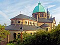
- Holy Cross Church (Église de l'Exaltation de la Sainte Croix); built in 1730; rebuilt between 1763 and 1771; In 1862 the vestibule and bell tower were added; 1911 Reconstruction in the style of historicism with a large dome
The first chapel, built in 1653, was built on land that the Lords of Condé had made available to their Catholic workers. Creutzwald's first cemetery was also located here. The chapel was subsequently used by the following villages: Creutzwald, Wilhelmsbronn, Lauterbach im Warndt and La Houve. Wilhelmsbronn and Lauterbach were in the area of the county of Sarrebrücken, while the other villages belonged to the Duchy of Lorraine. In order to be able to accommodate the believers in space, the foundation stone for a larger church was laid in April 1730, which was consecrated on December 24th of the same year by Pastor Maurice / Moritz Baur to the patronage title " Crossing " ( patronage day : September 14th).
In 1743 the four parishes petitioned the Bishop of Metz, Claude de Saint Simon, asking for a parish to be established. Thereupon Creutzwald was raised to a parish on October 13, 1747. However, this decision officially excluded the residents of Wilhelmsbronn and Lauterbach, who were in the county of Saarbrücken. Nevertheless, both villages received pastoral care from Creutzwald. The first pastor of the new parish was Frédéric / Friedrich Redinger.
The church, built in 1730, had to be renewed in 1763 due to its poor state of construction. The new building was laid out on an octagonal floor plan with a pyramidal roof and ridge turrets. Due to inadequate foundations, the church was dilapidated again in 1768, so that construction work had to be started again in 1771. In 1862 the church was expanded to include a vestibule and a bell tower, and in 1911 it was given its current shape.
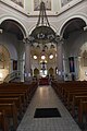
- Creutzwald, Holy Cross Church
Dome octagon
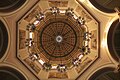
Look into the dome

Sanctuary

.jpg)

- St. Therese (Église Sainte-Thérèse), church in the Neuland district, 20th century
- Our Lady of Fatima (Église Notre Dame de Fatima), Breckelberg, 20th century
- Church of Christ the King (Église du Christ-Roi), 20th century
- St. Barbara Chapel (Chapelle Sainte-Barbe), 20th century
- Lourdes grotto, built in 1925 in the Neuland district
- Langenberg Chapel in the Houve Forest towards Falk ; on the outskirts of the community of Creutzwald; inaugurated in 1866; Every year on Whit Monday there is a pilgrimage to the chapel. The Mariengrotte was built by miners.
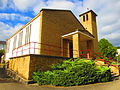
- Evangelical
- Lutheran Church (Église luthérienne), built from 1957 to 1963
The so-called "Huguenot Trail" leads past Creutzwald and its forests to Ludweiler im Warndt. The Huguenots from Kurzel-Kelsch used this route from 1685 to 1787 to get to the Calvinist Reformed Church of Ludweiler in what is now Saarland . The baptisms and weddings forbidden in their homeland took place here at the autumn fair. Numerous French Huguenots found refuge in the Saarland at that time, especially in the Protestant village of Ludweiler, which was founded in 1604 by Lorraine Calvinists. The practice of the Reformed religion was forbidden to French Protestants after the revocation of the Edict of Nantes in France. On October 18, 1685 , King Louis XIV repealed the edict in the Edict of Fontainebleau . The French Protestants were thus deprived of all religious and civil rights. As a result, hundreds of thousands fled France within a few months. The Huguenot Trail in Lorraine was inaugurated on June 19, 1994 by Lorraine and Saarland residents. It extends over a distance of 48 km. The trail is marked with a blue Huguenot cross on a white background. Information boards are set up at important stations. A "Huguenot March" traditionally takes place in September between Creutzwald and Ludweiler.
- New Apostolic
- New Apostolic Church (Église néo-apostolique), 20th century
- Islamic
- Al-Fath Mosque, 20th century
- Mosque in the Maroc district
leisure
The following leisure and sports facilities exist in the town of Creutzwald:
- Sports halls: Breckelberg, Cosec Garang, Jules Ferry, Schweitzer, Siège 1, Center, Houve
- Sailing club
- Boules court
- Tennis club
- Football stadium
- Archery facility
- Shooting facilities
- Mini golf course
- Judo club
- Swimming pool: Indoor pool with six lanes of 25 m length, possibility of extending two lanes to 50 m length, fun pool, paddling pool for children, 50 m slide, whirlpool, counter-current swimming pool, diving tower 15 m deep, outdoor pool, paddling pool, sunbathing area
- Bist reservoir (12 ha)
- Media library
- Culture hall (1450 seats or 3000 standing places)
- Municipal music and dance school
literature
- Cercle d'Histoire de Creutzwald: Creutzwald une histoire de villages et d'industries, tome 1: des origines à la fusion, Creutzwald 2014.
- Daniel Deutsch: De Wendel - an epoch in Warndt - history of an industrial dynasty, ed. from the local history association Warndt eV, Völklingen-Ludweiler 2011.
- Nicolas Dicop: Creutzwald, carrefour de la Houve, Creutzwald 1968.
- Local history association Warndt eV (ed.): The glassworks in Warndt, Völklingen-Ludweiler 1999.
- Heimatkundlicher Verein Warndt eV (Ed.): Der / Le Warndt, Völklingen 2006.
- Margot Stilz: History of the Nassau-Saarbrück village of Wilhelmsbrunn and the Creutzwalder coal money told according to documents, Volumes I and II, without location 2008.
Web links
Individual evidence
- ↑ https://www.creutzwald.fr/fr/histoire.html , accessed on May 6, 2019.
- ↑ a b c Bouteiller - Dictionnaire topographique de l'ancien département de la Moselle, rédigé en 1868
- ↑ https://www.creutzwald.fr/fr/histoire.html , accessed on May 6, 2019.
- ↑ Malte Helfer: The hard coal mining in Lorraine in the GR-Atlas (Atlas for the greater region around the Grand Duchy of Luxembourg) on the website of the University of Luxembourg, accessed on December 3, 2015.
- ^ Anton Haßlacher: The coal mining of the Prussian state in the area of Saarbrücken , Vol. 2: Historical development of the coal mining in the Saar area . Springer, Berlin 1904, p. 174.
- ↑ Ralf Banken: The industrialization of the Saar region 1815-1914 , Vol. 2: Vol. 2. The early industrialization 1850-1914 . Steiner, Stuttgart 2003, ISBN 3-515-07828-2 , p. 40.
- ↑ https://www.creutzwald.fr/fr/histoire.html , accessed on May 6, 2019.
- ↑ https://www.creutzwald.fr/fr/histoire.html , accessed on May 6, 2019.
- ↑ https://www.heraldry-wiki.com/heraldrywiki/index.php?title=Creutzwald , accessed on May 7, 2019.
- ↑ https://www.saarinfos.de/2017/12/stdtepartektiven-creutzwald-dillingen-ein-modell-fr-deutschland/ , accessed on June 7, 2019.
- ↑ https://www.saarbruecker-zeitung.de/saarland/saarlouis/dillingen/dicke-freunde-seit-50-jahren_aid-2239357 , accessed on June 7, 2019.
- ↑ https://www.creutzwald.fr/fr/situation-geographique.html , accessed on May 6, 2019.
- ↑ https://www.creutzwald.fr/fr/situation-geographique.html , accessed on May 6, 2019.
- ↑ https://www.creutzwald.fr/fr/situation-geographique.html , accessed on May 6, 2019.
- ↑ http://www.creutzwaldhistoire.fr/Eglise-Ste-Croix.38.html , accessed on May 7, 2019.
- ↑ https://www.voelklingen-im-wandel.de/stadtteile/ludweiler/hugenottenkirche/ , accessed on May 7, 2019.
- ↑ Ernst Mengin (Ed.): The Edict of Nantes - The Edict of Fontainebleau, Flensburg 1963.
- ↑ Heinz Duchhardt (ed.): The exodus of the Huguenots: the repeal of the Edict of Nantes in 1685 as a European event, Cologne and Vienna 1985.
- ↑ https://www.saarland-lese.de/index.php?article_id=512 , accessed on May 7, 2019.
- ↑ https://www.saarbruecker-zeitung.de/saarland/schleife-bei-creutzwald-erweitert-den-hugenottenweg_aid-1045314 , accessed on May 7, 2019.
- ↑ https://www.creutzwald.fr/ , accessed on May 9, 2019.