Heining-lès-Bouzonville
| Heining-lès-Bouzonville | ||
|---|---|---|

|
|
|
| region | Grand Est | |
| Department | Moselle | |
| Arrondissement | Forbach-Boulay-Moselle | |
| Canton | Bouzonville | |
| Community association | Bouzonvillois-Trois Frontières | |
| Coordinates | 49 ° 19 ′ N , 6 ° 35 ′ E | |
| height | 223-336 m | |
| surface | 6.03 km 2 | |
| Residents | 477 (January 1, 2017) | |
| Population density | 79 inhabitants / km 2 | |
| Post Code | 57320 | |
| INSEE code | 57309 | |
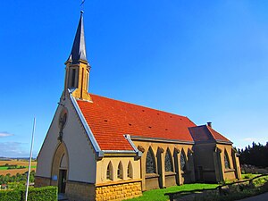
 Church of St. Jeanne d'Arc in the Leiding district |
||
Heining-lès-Bouzonville (German Heiningen bei Busendorf ) is a French commune with 477 inhabitants (as of January 1, 2017) in the Moselle department in the Grand Est region (until 2015 Lorraine ).
geography
The community of Heining is located directly on the German-French border. The German neighboring municipality is Wallerfangen , especially its district of Leidingen .
The districts of Schreckling and Leiding belong to Heining-lès-Bouzonville (only separated from the German Leidingen by a street).
history
Other spellings were: Hunninga (10th century), Hunningen (1220), Hueningen (15th century), Huningen (1594), Hining (18th century), Heining ou Henning (1756), Heining (1793).
Heining belonged to the Second Peace of Paris in 1815 up to the border convention between Prussia and France in 1829 to Prussia .
Population development
| year | 1962 | 1968 | 1975 | 1982 | 1990 | 1999 | 2007 | 2017 |
| Residents | 261 | 263 | 311 | 453 | 522 | 496 | 476 | 477 |
