
Faulquemont
| Faulquemont | ||
|---|---|---|

|
|
|
| region | Grand Est | |
| Department | Moselle | |
| Arrondissement | Forbach-Boulay-Moselle | |
| Canton | Faulquemont | |
| Community association | District Urbain de Faulquemont | |
| Coordinates | 49 ° 2 ' N , 6 ° 36' E | |
| height | 241-401 m | |
| surface | 18.79 km 2 | |
| Residents | 5,306 (January 1, 2017) | |
| Population density | 282 inhabitants / km 2 | |
| Post Code | 57380 | |
| INSEE code | 57209 | |
| Website | Faulquemont | |
 Headquarters of the Faulquemont coal mine |
||

Faulquemont ( German Falkenberg , Lorraine Folkenburch ) is a French commune with 5306 inhabitants (as of January 1, 2017) in the Moselle department in the Grand Est region (until 2015 Lorraine ).
The inhabitants call themselves Faulquinois . Their nicknames are "stänesel" or "stenesel".
geography
The community of Faulquemont is located on the Deutsche Nied , ten kilometers southwest of Saint-Avold and about 33 kilometers east of Metz . In addition to the Bonhouse ( Bohnhaus ) and Herrenwald farms , Chémery-lès-Faulquemont ( Schemmerich ) in the south has been part of Faulquemont since May 1, 1973 .
history
The place was first mentioned in 1210 as falconis mons , then in 1238 as Faukemont . In the Thirty Years War it was so badly devastated that in 1650 only ten inhabitants were left. It was not until 1683 that the reconstruction and resettlement of Faulquemont began in earnest.
Faulquemont has belonged to France since 1766. 1871–1918 it belonged to the German Empire .
Population development
| year | 1962 | 1968 | 1975 | 1982 | 1990 | 1999 | 2007 | 2017 |
| Residents | 5201 | 5543 | 5533 | 5873 | 5432 | 5478 | 5502 | 5306 |
Culture and sights
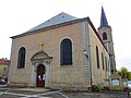
Saint Vincent Church
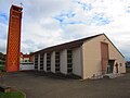
Sainte-Marie-Reine Church

Saint-Vincent cemetery chapel

Ossuary

synagogue


literature
- Marcel Lutz: CHÉMERY Moselle, France . In: Richard Stillwell et al. a. (Ed.): The Princeton Encyclopedia of Classical Sites. Princeton University Press, Princeton NJ 1976, ISBN 0-691-03542-3 .
Web links
Individual evidence
- ^ Passé-Présent, La Moselle dévoilée , n ° 10, (Septembre-octobre-novembre 2013)