Folschviller
| Folschviller | ||
|---|---|---|

|
|
|
| region | Grand Est | |
| Department | Moselle | |
| Arrondissement | Forbach-Boulay-Moselle | |
| Canton | Saint-Avold | |
| Community association | Saint-Avold synergy | |
| Coordinates | 49 ° 5 ' N , 6 ° 41' E | |
| height | 246-387 m | |
| surface | 9.46 km 2 | |
| Residents | 3,993 (January 1, 2017) | |
| Population density | 422 inhabitants / km 2 | |
| Post Code | 57730 | |
| INSEE code | 57224 | |
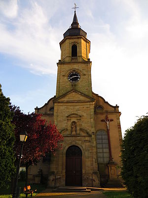
 Church of the Blessed Virgin Mary Nativity |
||
Folschviller (German Folschweiler ) is a French commune with 3993 inhabitants (as of January 1, 2017) in the Moselle department in the Grand Est region (until 2015 Lorraine ). It belongs to the Arrondissement Forbach-Boulay-Moselle and the municipality association Saint-Avold Synergie .
geography
Folschviller is located about five kilometers southwest of Saint-Avold , near the border with Saarland at an altitude of 270 m above sea level. The upper Nied Allemande (German Nied) flows through the southeast of the municipality . The north of the municipality is forested ( Bois de Furst ), and southeast of the Nied, the municipality has a share of a forest area ( Ubernied ).
The old village center with the church in the south and the former mining settlement Cíté Furst in the north have grown together. A new center with a market square, town hall (Mairie) and school was built around the middle.
Neighboring communities of Folschviller are Saint-Avold and Valmont in the north, Altviller in the northeast, Vahl-Ebersing and Lelling in the southeast, Teting-sur-Nied in the southwest and Laudrefang in the northwest.
history
Other spellings were: Wolswilre (1275), Folchweiler (1751), Folschweiler (1793), Folschwiller (19th century).
Folschwiller was part of the Trois-Évêchés in the former county of Kriechingen ( Comté de Créhange ) before the French Revolution .
From 1909 to 1979 hard coal was mined in Folschville. After the Second World War, funding was intensified and the Cité Furst workers' settlement was created .
Population development
| year | 1962 | 1968 | 1975 | 1982 | 1990 | 1999 | 2007 | 2017 | |
| Residents | 5078 | 4825 | 4712 | 4957 | 4581 | 4635 | 4308 | 3993 | |
| Sources: Cassini and INSEE | |||||||||
Attractions
- Church of the Nativity ( Église Paroissiale de la Nativité-la-Bienheureuse-Vierge-Marie ), built in place of a previous building in 1832 (choir), expanded by a new tower in 1863
- Church of St. Johannes Bosco ( Église Saint-Jean-Bosco ) in the Furst district
- Fourteen Holy Helpers Chapel ( Chapelle des Saints-Auxiliaires ), built before 1781
Headframe
The headframe of the former Folschviller 1 shaft has been preserved from the former coal mining industry, which was discontinued in 1979. The shaft has a diameter of 6.55 m and extends to a depth of 907 m.
Economy and Infrastructure
After the end of hard coal mining in March 1979, a major wave of emigration was prevented by the establishment of new industries. So the Parc Industriel de Furst was created in the area of the old colliery . There and in the industrial area northeast of the old village center, numerous companies in the metal and food industry as well as craft and service companies have settled.
The nearby town of Saint-Avold enables cheap supraregional transport connections by road and train ( Autoroute A4 , train lines to Metz, Forbach and Saarbrücken).
supporting documents
- ^ Bouteiller - Dictionnaire topographique de l'ancien département de la Moselle (written in 1868)
- ↑ Folschviller on cassini.ehess.fr
- ↑ Folschviller on insee.fr
- ↑ Entry on patrimoine-de-france.org ( page no longer available , search in web archives ) Info: The link was automatically marked as defective. Please check the link according to the instructions and then remove this notice.
- ↑ Entry on patrimoine-de-france.org ( page no longer available , search in web archives ) Info: The link was automatically marked as defective. Please check the link according to the instructions and then remove this notice.
- ↑ Description on lorraine.charbon.free.fr
- ↑ Furst industrial zone ( Memento of the original from November 5, 2011 in the Internet Archive ) Info: The archive link was automatically inserted and not yet checked. Please check the original and archive link according to the instructions and then remove this notice.

