Pontpierre
| Pontpierre | ||
|---|---|---|

|
|
|
| region | Grand Est | |
| Department | Moselle | |
| Arrondissement | Forbach-Boulay-Moselle | |
| Canton | Faulquemont | |
| Community association | District Urbain de Faulquemont | |
| Coordinates | 49 ° 3 ' N , 6 ° 39' E | |
| height | 243-345 m | |
| surface | 8.48 km 2 | |
| Residents | 724 (January 1, 2017) | |
| Population density | 85 inhabitants / km 2 | |
| Post Code | 57380 | |
| INSEE code | 57549 | |
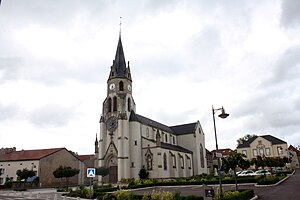
 Saint-Calixte church |
||
Pontpierre (German Steinbiedersdorf , Lorraine Stémbidaschtroff ) is a French commune with 724 inhabitants (as of January 1, 2017) in the Moselle department in the Grand Est region (until 2015 Lorraine ).
geography
The municipality of Pontpierre is located on the German Nied ( Nied Allemande ) east of Faulquemont and south of Saint-Avold .
history
First mentioned in 1026 as Stegenbiedersdorf (1604: Pont de Pierre).
The place was formerly part of the county of Kriechingen and was occupied and annexed by France in 1793, which was recognized in the Peace of Lunéville in 1801 . The place received its French name, which refers to the bridge over the Nied , only afterwards.
From 1871 to 1918 Pontpierre was temporarily part of the German Empire again .
Pontpierre had a small Jewish community in the 18th century, about which a book was published in 1999, which was also translated into English and Russian .
Population development
| year | 1962 | 1968 | 1975 | 1982 | 1990 | 1999 | 2007 | 2015 |
| Residents | 628 | 590 | 569 | 579 | 661 | 725 | 789 | 733 |
literature
- Claudia Ulbrich : Shulamit and Margarete - Power, Gender and Religion in a Rural Society of the 18th Century . Böhlau, Vienna 1999.
