
Do it
| Do it | ||
|---|---|---|

|
|
|
| region | Grand Est | |
| Department | Moselle | |
| Arrondissement | Forbach-Boulay-Moselle | |
| Canton | Saint-Avold | |
| Community association | Saint-Avold synergy | |
| Coordinates | 49 ° 6 ′ N , 6 ° 45 ′ E | |
| height | 250-340 m | |
| surface | 16.95 km 2 | |
| Residents | 2,767 (January 1, 2017) | |
| Population density | 163 inhabitants / km 2 | |
| Post Code | 57730 | |
| INSEE code | 57428 | |

Macheren (German Machern ) is a French commune with 2,767 inhabitants (as of January 1, 2017) in the Moselle department in the Grand Est region (until 2016 Lorraine ). Carling belongs to the Forbach-Boulay-Moselle arrondissement .
The districts of Petit-Ebersviller ( Klein Ebersweiler ), Lenzviller and Moulin-Neuf (formerly: Ney-Muhl ) belong to Macheren .
location
Macheren is located in the north of the historic Lorraine region , immediately east of Saint-Avold .
history
Macheren was first mentioned in 1121 as Machera . Petit-Ebersviller was first mentioned in 1220 as Ebersswilre .
Population development
| year | 1962 | 1968 | 1975 | 1982 | 1990 | 1999 | 2015 |
| Residents | 1,044 | 1,842 | 1,756 | 2,063 | 2,786 | 2,809 | 2,815 |
Attractions
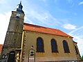
- Saint-Thomas church from the 18th century (Macheren).
- Saint-Étienne church from 1752 (Petit-Ebersviller).

Saint Thomas Church
Saint-Etienne church in Petit-Ebersviller

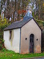
Notre-Dame-de-Lorette chapel in Lenzviller
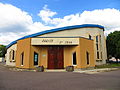
Saint-Jean-Bosco Church
Chapel Bour (le Moulin Neuf)


Web links
Commons : Macheren - collection of images, videos and audio files
Individual evidence
- ^ Administration générale des postes, Dictionnaire des postes aux lettres, contenant les noms des villes, communes et principaux lieux habités de la France , Paris, Imprimerie Royale, 1845.