Vallerange
| Vallerange | ||
|---|---|---|

|
|
|
| region | Grand Est | |
| Department | Moselle | |
| Arrondissement | Forbach-Boulay-Moselle | |
| Canton | Sarralbe | |
| Community association | Saint-Avold synergy | |
| Coordinates | 48 ° 57 ' N , 6 ° 41' E | |
| height | 236-295 m | |
| surface | 6.64 km 2 | |
| Residents | 209 (January 1, 2017) | |
| Population density | 31 inhabitants / km 2 | |
| Post Code | 57370 | |
| INSEE code | 57687 | |
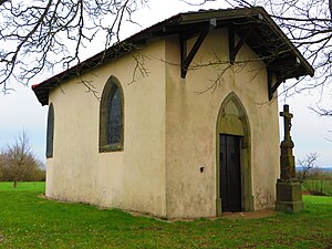
 Maria in Ruh chapel in the Hollerlaengen area |
||
Vallerange (German Walleringen ) is a French commune with 209 inhabitants (as of January 1, 2017) in the Moselle department in the Grand Est region (until 2015 Lorraine ). It belongs to the Forbach-Boulay-Moselle arrondissement .
geography
Vallerange is located about 55 kilometers as the crow flies southeast of Metz at an altitude between 236 and 295 m above sea level, the mean height is 250 m. The municipality covers 6.64 km².
Neighboring communities of Vallerange are Bérig-Vintrange in the north, Grostenquin in the northeast, Bermering in the southeast, Racrange in the south, Morhange in the southwest and Harprich in the northwest.
history
The local history goes back to the year 790 as Vylaru.
Population development
| year | 1962 | 1968 | 1975 | 1982 | 1990 | 1999 | 2007 |
| Residents | 254 | 260 | 213 | 208 | 219 | 231 | 211 |
Economy and Infrastructure
The place lies between the national road N74 and the department road D27 northwest of Morhange .
