Fouligny
| Fouligny | ||
|---|---|---|

|
|
|
| region | Grand Est | |
| Department | Moselle | |
| Arrondissement | Forbach-Boulay-Moselle | |
| Canton | Faulquemont | |
| Community association | District Urbain de Faulquemont | |
| Coordinates | 49 ° 6 ′ N , 6 ° 30 ′ E | |
| height | 219-315 m | |
| surface | 5.96 km 2 | |
| Residents | 195 (January 1, 2017) | |
| Population density | 33 inhabitants / km 2 | |
| Post Code | 57220 | |
| INSEE code | 57230 | |
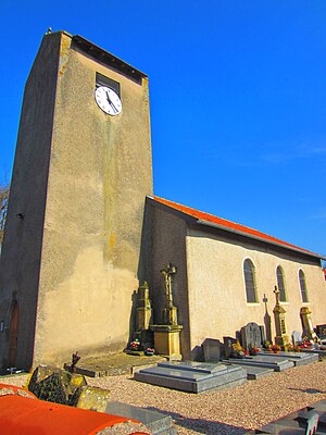
 Saint-Rémi church |
||
Fouligny (German Füllingen , Franconian Fillingen ) is a French commune with 195 inhabitants (as of January 1, 2017) in the Moselle department in the Grand Est region (until 2015 Lorraine ).
geography
Fouligny is located on the N3 national road between Saint-Avold and Metz on the banks of the Deutsche Nied , about 40 kilometers from Saarbrücken .
history
Historical names of the place: Fullinga (1181), Fuligny (1245), Vollingia (1299), Fullingam (1302), Fullenges (1420), Fullenga - Fullingen (1544), Filling (1594), Foligny (1662), Ullinge - Ullenge (1681), Filling - Folligni (1688), Foligny (late 17th century), Fouligny, Füllingen (1871), Fouligny (1918), Füllingen (August 2, 1940), Fouligny (1944).
Population development
| year | 1962 | 1968 | 1975 | 1982 | 1990 | 1999 | 2007 |
| Residents | 137 | 151 | 136 | 177 | 175 | 191 | 201 |
Worth seeing
- The Fouligny mill is the only water mill in the Boulay-Moselle arrondissement that is still in operation.
supporting documents
- ^ Ernest de Bouteiller: "Dictionnaire topographique de l'ancien département de la Moselle", 1868.
Web links
Commons : Fouligny - collection of images, videos and audio files
