Guinglange
| Guinglange | ||
|---|---|---|

|
|
|
| region | Grand Est | |
| Department | Moselle | |
| Arrondissement | Forbach-Boulay-Moselle | |
| Canton | Faulquemont | |
| Community association | District Urbain de Faulquemont | |
| Coordinates | 49 ° 4 ′ N , 6 ° 32 ′ E | |
| height | 222-308 m | |
| surface | 10.38 km 2 | |
| Residents | 329 (January 1, 2017) | |
| Population density | 32 inhabitants / km 2 | |
| Post Code | 57690 | |
| INSEE code | 57276 | |
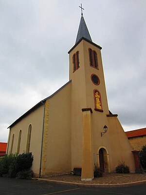
 Saint-Pierre church |
||
Guinglange (German: Gänglingen ) is a French commune with 329 inhabitants (as of January 1, 2017) in the Moselle department in the Grand Est region (until 2015 Lorraine ).
geography
The districts of Helfling and Vitrange (1420: Wittrenges ) belong to Guinglange . Neighboring municipalities are Fouligny in the north, Haute-Vigneulles in the northeast, Flétrange and Elvange in the east, Hémilly in the south, Villers-Stoncourt , Servigny-lès-Raville and Raville in the west.
history
The place was first mentioned in 848 as Gangoniaga . Then Gengelingen (1377), Guingelingen (1500).
Population development
| year | 1962 | 1968 | 1975 | 1982 | 1990 | 2000 | 2008 |
| Residents | 210 | 217 | 192 | 224 | 841 | 222 | 298 |
Individual evidence
- ↑ Rudolf Schützeichel - Giessen Field Names Colloquium (1985)
- ↑ Monika Buchmüller-Pfaff - settlement names between late antiquity and the early Middle Ages (1990)
- ^ The Franconian and Alemannic Settlements in Gaul (2011)
- ↑ Data from INSEE ( page no longer available , search in web archives ) Info: The link was automatically marked as defective. Please check the link according to the instructions and then remove this notice.
Web links
Commons : Guinglange - collection of images, videos and audio files
