Cappel (Moselle)
| Cappel | ||
|---|---|---|

|
|
|
| region | Grand Est | |
| Department | Moselle | |
| Arrondissement | Forbach-Boulay-Moselle | |
| Canton | Freyming-Merlebach | |
| Community association | Freyming-Merlebach | |
| Coordinates | 49 ° 4 ′ N , 6 ° 51 ′ E | |
| height | 232-301 m | |
| surface | 5.97 km 2 | |
| Residents | 701 (January 1, 2017) | |
| Population density | 117 inhabitants / km 2 | |
| Post Code | 57450 | |
| INSEE code | 57122 | |
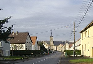
 Rue de la Liberation, with the Saint-Gengoulf church in the background |
||
Cappel is a French commune with 701 inhabitants (as of January 1, 2017) in the Moselle department in the Grand Est region (until 2015 Lorraine ). It belongs to the Forbach-Boulay-Moselle arrondissement and the Freyming-Merlebach community association founded in 2001 .
geography
The community area of around 6 km² is bounded in the north by the source stream of the Deutsche Nied (a Saar tributary) and in the south by the Rimmelhoffenbach , which flows into the Saar via the Mutterbach and Albe . Cappel lies on the watershed between the two source streams, which flow in opposite directions . Forests make up about 15% of the municipal area, most of the gently rolling terrain consists of arable land and grassland.
Cappel consists of two settlement axes running in a west-east direction, the northern one around the Rue de l'Église with some old farms being the older. The southern axis along national road 56 was only created in the 20th century. Both axes are connected by two streets laid out in a north-south direction, the Rue de la Liberation and Rue du Château Neuf , which run about 200 meters apart. This created a two-hectare agricultural area in the center of the village.
Neighboring communities of Cappel are Seingbouse in the north, Farschviller in the northeast, Loupershouse in the east, Hoste in the southeast and south, Barst and Biding in the west and the Barster district of Marienthal in the northwest.
history
The municipality of Cappel was established in 1790 with the district of Valette to the south . This was incorporated into Hoste in 1811 . Between 1813 and 1826, Cappel was also part of Hoste.
Population development
| 1962 | 1968 | 1975 | 1982 | 1990 | 1999 | 2007 | 2017 | ||
| 486 | 491 | 492 | 533 | 714 | 723 | 671 | 701 | ||
| Sources: Cassini and INSEE | |||||||||
Attractions
- Saint-Gengoulf church from the 18th century, restored in 1863
- neo-Gothic chapel in the Cappel cemetery from 1860
- a half-timbered house in rue de la Forêt 121 ( Monument historique ), rare in northern Lorraine
Economy and Infrastructure
There are five farms in the municipality (fruit growing, cattle breeding). The old Cappel is dominated by agriculture, while many of the houses on the national road are more recent, due to the convenient transport links to the large industrial parks in the area, to which some of the residents commute.
National road 56 leads through Cappel from Saint-Avold to Sarralbe . The Farébersviller connection on the Paris – Strasbourg motorway is five kilometers from Cappel.
supporting documents
- ↑ toponym on cassini.ehess.fr
- ↑ Cappel on cassini.ehess.fr
- ↑ Cappel on insee.fr
- ↑ Farms on annuaire-mairie.fr (French)
