
Porcelette
| Porcelette | ||
|---|---|---|

|
|
|
| region | Grand Est | |
| Department | Moselle | |
| Arrondissement | Forbach-Boulay-Moselle | |
| Canton | Saint-Avold | |
| Community association | Saint-Avold synergy | |
| Coordinates | 49 ° 9 ' N , 6 ° 39' E | |
| height | 213-342 m | |
| surface | 13.44 km 2 | |
| Residents | 2,485 (January 1, 2017) | |
| Population density | 185 inhabitants / km 2 | |
| Post Code | 57890 | |
| INSEE code | 57550 | |
| Website | www.porcelette.fr | |
 logo |
||

Porcelette is a French commune with 2,485 inhabitants (as of January 1, 2017) in the Moselle department in the Grand Est region (until 2016 Lorraine ). Porcelette is part of the Forbach-Boulay-Moselle arrondissement .
geography
Porcelette is not far from the Saarland border . Neighboring communities are Ham-sous-Varsberg in the north, this in the northeast, Saint-Avold in the southeast and Boucheporn in the southwest.
history
Porcelette was founded in 1611 by a French clergyman, the Abbé des Porcelets de Maillane , and is also named after him. 1915–1918 the place was called Porzelet , 1940–1944 Grünwald .
Population development
| year | 1962 | 1968 | 1975 | 1982 | 1990 | 1999 | 2007 |
| Residents | 1,553 | 1,659 | 1.918 | 2,097 | 2,322 | 2,458 | 2,467 |

Croix-Glorieuse Church
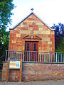
Notre-Dame chapel


Web links
Commons : Porcelette - collection of images, videos and audio files