Gomelange
| Gomelange | ||
|---|---|---|

|
|
|
| region | Grand Est | |
| Department | Moselle | |
| Arrondissement | Forbach-Boulay-Moselle | |
| Canton | Boulay-Moselle | |
| Community association | Houve-Pays Boulageois | |
| Coordinates | 49 ° 15 ′ N , 6 ° 28 ′ E | |
| height | 197-260 m | |
| surface | 9.40 km 2 | |
| Residents | 497 (January 1, 2017) | |
| Population density | 53 inhabitants / km 2 | |
| Post Code | 57220 | |
| INSEE code | 57252 | |
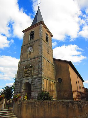
 St. Martin Church |
||
Gomelange (German Gelmingen ) is a French commune with 497 inhabitants (as of January 1, 2017) in the Moselle department in the Grand Est region (until 2015 Lorraine ).
geography
The municipality of Gomelange is located on the Nied , about eight kilometers southwest of Bouzonville , not far from the border with Saarland . The districts of Guirlange and Colming belong to Gomelange .
history
The place was first mentioned in 1184 as Gelmelingen , then Gaimelanges (1276), and Gomelingen (16th century).
Population development
| year | 1962 | 1968 | 1975 | 1982 | 1990 | 1999 | 2007 |
| Residents | 369 | 409 | 390 | 400 | 408 | 403 | 529 |
Attractions
- Ecomusée ( Ecomuseum ) "Vieille Maison 1710 de Gomelange", renovated Lorraine house from 1710 and turned into a museum
- Recently renovated organ in the Church of St. Martin (classified as a monument historique )
Web links
Commons : Gomelange - collection of images, videos and audio files
