Lauterbach (Warndt)
|
Lauterbach
|
||
|---|---|---|
| Coordinates: 49 ° 11 ′ 2 " N , 6 ° 44 ′ 41" E | ||
| Height : | 220 m above sea level NN | |
| Area : | 18.83 km² | |
| Residents : | 2611 (Dec. 31, 2010) | |
| Population density : | 139 inhabitants / km² | |
| Incorporation : | 1st January 1974 | |
| Postal code : | 66333 | |
| Area code : | 06802 | |
|
Location of Lauterbach in Saarland |
||
Lauterbach is a district of the city of Völklingen in the Saarland regional association Saarbrücken . Until the end of 1973 Lauterbach was an independent municipality.
geography
The Lauterbach district has two mountains: the Mühlenberg and the Brunnenberg. The Mühlenbach used to be branched off from the Lauterbach brook to operate a mill.
location
The place is on the German-French border in the extreme southwest of the Saarland . Its neighboring towns are Ludweiler and Karlsbrunn on the German side and Carling on the French side . In October 2005 Lauterbach had 2672 inhabitants. It is located in the Warndt , an extensive forest area (former hunting area of the Counts of Nassau-Saarbrücken). It is named after the Lauterbach, a small brook that rises in France and flows into the Rossel .
Districts
The actual town center can be roughly divided into upper and lower villages. In addition, there have been some new development areas since the 1950s.
history
On February 11, 1707, a glassworks was built on this stream. The place Lauterbach developed from this. When the county of Nassau-Saarbrücken in 1770 Lauterbach's neighboring village Karlingen (today: Carling) to Ludwig XV. resigned, Lauterbach became a border town. In 1792 French Revolution troops occupied the county of Nassau-Saarbrücken. All municipalities of the Warndt were then merged into a Mairie , the administrative seat of which was in Ludweiler (a neighboring town of Lauterbach). After Napoleon's defeat , Lauterbach was added to Prussia at the Congress of Vienna in 1815 and became part of the Rhine Province in 1822 . With the victory of Prussia and its allies in the Franco-Prussian War in 1871, the state border fell away. Lauterbach bordered from then on to the realm of Alsace-Lorraine . Lauterbach has been a border town again since 1918. In 1939 and 1944 - due to the war - there was numerous destruction. From 1947 to 1957 Lauterbach was part of the then autonomous Saarland . Since 1957 it has belonged to the Federal Republic of Germany with the state of Saarland . In 1969 Willy Brandt visited Lauterbach.
As part of the regional and administrative reform in Saarland , the previously independent municipality of Lauterbach was assigned to the city of Völklingen on January 1, 1974.
After the creation of the Schengen area , the Lauterbach customs station was closed.
development
Lauterbach was founded as a glassmaking village. In the course of the French Revolution, the sales markets were lost, so that the glassworks closed in 1790. A transitional period followed in which the residents mainly farmed. With the beginning of industrialization , numerous pits were built on the Saar and in Lorraine , so that Lauterbach turned into a mining village.

politics
Mayor: Dieter Peters ( SPD )
The distribution of votes in the local council after the last local election on May 25, 2014:
coat of arms
The former municipal coat of arms of Lauterbach is a green shield (= Warndtwald), divided diagonally to the left by a wavy bar (= symbol for the Lauterbach). Two glassmaker's pipes in the upper half represent the creation of the place from a glassworks. A wolf tang in the lower half shows that Lauterbach belongs to the Nassau-Saarbrücken county . The coat of arms was awarded on June 15, 1964.
Attractions
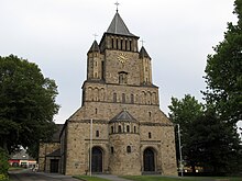
- Catholic Church of St. Paulinus in neo-Romanesque style ( Warndtdom ), named after Paulinus von Trier
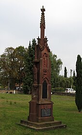
- Neo-Gothic memorial for the 35 German and French miners killed in a mining accident in 1876
- Village cross from 1785
- Memorial to Colonel Humbert de Girecourt, who died in a hunt in the 19th century
- The Huguenot Trail / Sentier des Huguenots runs through Lauterbach . The hiking trail corresponds to the route that the Huguenots from Courcelles in France had to cover between 1685 and 1787 in order to be able to attend the Reformed church service and to carry out weddings and baptisms in Lauterbach's neighboring village of Ludweiler. It starts at the church of Courcelles-Chaussy , runs through Lauterbach and ends at the Protestant church in Ludweiler .
architecture
The townscape is traditionally shaped by the so-called Southwest German farmhouse type, which can be found in large parts of the Saarland and Luxembourg. It is a so-called Einhaus , i. H. The apartment and cattle shed are under one roof with a continuous roof ridge, but in two separate building sections. In the facade, the internal structure is sometimes emphasized by a pilaster (= vertical strip of gemstones). The windows of the living area are often arranged on both sides of the entrance door. The plaster was usually done with lime plaster. Lauterbach's south-west German single houses were traditionally single-storey and two rooms deep, so that all living rooms have daylight.
Since this type of house required large quantities of stones to build, “small quarries” were built in the immediate vicinity of the village. Occasionally, the remains of Roman settlements in the Warndt Forest were looted. The walls of windows, doors and barn doors were made from local sandstone.
Many of these farmhouses in Lauterbach were divided through inheritance divisions or sales and the stable side was converted into a second residential part.
Legends from Lauterbach
- The giant rooster from Lauterbach
- The swan on the warning pond
Well-known people from Lauterbach
- The so-called “Lauterbacher Pastor” (i.e. Pastor Robert Wagner, Pastor von Lauterbach 1907–1925) was one of the most well-known complementary physicians / naturopaths in Saarland at the beginning of the 20th century.
- The art educator, visual artist and author of novels and poetry Günter Kerner (1936–2017) was born in Lauterbach and spent most of his life there.
- The European amateur boxing champion from 1957 Manfred Gaus has lived in Lauterbach for decades.
- The soccer player Nico Weißmann was born in Lauterbach and learned to play soccer here.
Web links
- Official website
- Information about Lauterbach at www.voelklingen-im-wandel.de
- Literature on Lauterbach (Warndt) in the Saarland Bibliography
- www.lauterbach-saar.de
Individual evidence
- ↑ Population statistics , City of Völklingen
- ↑ Restructuring Act - NGG of December 19, 1973, § 2, published in the Saarland Official Gazette 1973, No. 48, p. 853 (PDF page 25; 499 kB)
- ^ Federal Statistical Office (ed.): Historical municipality directory for the Federal Republic of Germany. Name, border and key number changes in municipalities, counties and administrative districts from May 27, 1970 to December 31, 1982 . W. Kohlhammer, Stuttgart / Mainz 1983, ISBN 3-17-003263-1 , p. 807 .


