Bubenheim (Treuchtlingen)
|
Bubenheim
City of Treuchtlingen
Coordinates: 48 ° 59 ′ 23 " N , 10 ° 53 ′ 34" E
|
|
|---|---|
| Height : | 417 m |
| Residents : | 349 (Dec. 31, 2019) |
| Incorporation : | April 1, 1971 |
| Postal code : | 91757 |
| Area code : | 09142 |
|
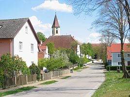
The center of Bubenheim
|
|
Bubenheim is a district of the town of Treuchtlingen in the central Franconian district of Weißenburg-Gunzenhausen in Bavaria with just under 400 inhabitants.
geography
The village is located in the midst of orchards in the Altmühltal in the southern Franconian Jura , about 4 km northwest of Treuchtlingen. The main part is located on a south-facing slope around the Bubenheimer Berg , also known as the "High Stone", on which 15 million year old types of rock from the Ries ejection (meteorite impact) can be found. The resting place of Vielsteine (476 m above sea level) offers a wide panoramic view. The southwestern border forms the Altmühl , into which the Rohrach flows at the western end of the village. Not far to the east is the hamlet of Hagenau , on the other side of the Altmühl there is Zollmühle , Ziegelmühle and Wettelsheim .
history
Settlement finds from the area go back to the Stone Age . A Celtic settlement is documented near the place . Probably originated in the 7th or 8th century, Bubenheim is first mentioned in the 8th century: In the year 792 or 793 Charlemagne visited the Pubnhaim (= "to the home of Buobo") on the occasion of the construction of the fossa Carolina . In the 13th century the Counts of Graisbach were wealthy there, later among others the Margraves of Brandenburg-Ansbach and the Prince-Bishops of Eichstätt . In 1824 there were 35 properties with 222 residents.
On April 1, 1971, the formerly independent community of Bubenheim was incorporated into the city of Treuchtlingen.
Worth seeing
The Holy Cross Church, built in 1749, is located in the old town center along the Altmühl. In 1986 it was renovated and most of the original baroque character was restored.
Economy and Infrastructure
Some farms are still in the village, but residential development predominates. The Treuchtlingen-Bubenheim airfield is located northwest of Bubenheim . The district road WUG 5 passes to the west .
literature
- Gottfried Stieber: Bubenheim . In: Historical and topographical news from the Principality of Brandenburg-Onolzbach . Johann Jacob Enderes, Schwabach 1761, p. 264-265 ( digitized version ).
Web links
Individual evidence
- ↑ Population of the districts in the municipality of Treuchtlingen. In: https://www.treuchtlingen.de/ . City of Treuchtlingen, accessed on May 9, 2020 .
- ↑ Weißenburger Tagblatt of July 3, 2015, p. 11: Brief outline of the history
- ^ Wilhelm Volkert (ed.): Handbook of Bavarian offices, communities and courts 1799–1980 . CH Beck, Munich 1983, ISBN 3-406-09669-7 , p. 592 .

