
Bohmfeld
| coat of arms | Germany map | |
|---|---|---|

|
Coordinates: 48 ° 52 ' N , 11 ° 22' E |
|
| Basic data | ||
| State : | Bavaria | |
| Administrative region : | Upper Bavaria | |
| County : | Eichstatt | |
| Management Community : | Eitensheim | |
| Height : | 487 m above sea level NHN | |
| Area : | 16.27 km 2 | |
| Residents: | 1684 (Dec. 31, 2019) | |
| Population density : | 104 inhabitants per km 2 | |
| Postal code : | 85113 | |
| Area code : | 08406 | |
| License plate : | EGG | |
| Community key : | 09 1 76 116 | |
| LOCODE : | DE 6B7 | |
| Address of the municipal administration: |
Hofstetter Strasse 3 85113 Böhmfeld |
|
| Website : | ||
| First Mayor : | Alfred Ostermeier ( SPD / Free Voters ) | |
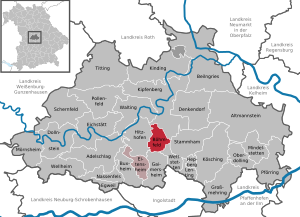
| Location of the municipality of Böhmfeld in the district of Eichstätt | ||
  |
||

Böhmfeld is a municipality in the Upper Bavarian district of Eichstätt and a member of the Eitensheim administrative community .
geography
The community is located in the Ingolstadt region. There is only the district and part of the municipality Böhmfeld.
Neighboring places and communities
| Schelldorf (Kipfenberg) | ||
| Hofstetten (Hitzhofen) |
.svg)
|
Stammham |
| Hitzhofen | Lippertshofen (Gaimersheim) | Echenzell ( Wettstetten ) |
history
Until the church is planted
Until 1803 Böhmfeld was an office of the high pin Eichstätt (the lower courts was amended by Eichstätter Mediaten monastery of St. Walburg exercised), which since 1500 in the Franconian Circle lay in Reichsdeputationshauptschluss of hochstiftischen area to Archduke in 1803 with most of Ferdinand of Tuscany fell. Since the peace treaties of Brno and Pressburg in 1805, the place has belonged to Bavaria .
Population development
Between 1988 and 2018 the municipality grew from 1,070 to 1,665 by 595 inhabitants or 55.6%.
- 1970: 815 inhabitants
- 1987: 1086 inhabitants
- 1991: 1193 inhabitants
- 1995: 1386 inhabitants
- 2000: 1555 inhabitants
- 2005: 1652 inhabitants
- 2010: 1622 inhabitants
- 2015: 1644 inhabitants
- 2019: 1781 inhabitants
politics
Municipal council
The Böhmfeld municipal council has twelve members.
(Status: local election March 9, 2014 )
mayor
Alfred Ostermeier (* 1948) of the SPD has been mayor since May 1, 1984.
coat of arms
Blazon : The coat of arms shows "split of silver and red, in front above a raised green three-mountain top, which is covered with a silver wave tip, the red curvature of an abbess's staff, behind the growing golden Bonifatiussäule."


Attractions
- Catholic parish church of St. Boniface , built in the 11th century andconsecratedby Bishop Gundekar II ; from her still the basement of the choir tower; 1596 church expansion and tower addition; 1792–1793 new church building, baroque furnishings; Rococo main altar from 1756, broughtto Böhmfeld in1804 from the secularized Kaisheimer chapel in Ingolstadt , altarpiece with Saint Bernhard and Maria by Ingolstadt rococo artist Johann Evangelist Hölzl .
Architectural monuments
Economy and Infrastructure
Economy including agriculture and forestry
The municipal tax receipts in 1999 amounted to the equivalent of 612 T €, of which the equivalent of 81 T € (net) was trade tax income. In 1998, according to official statistics in the manufacturing industry and in the trade and transport sector, there were no employees subject to social security contributions at the place of work. In other economic areas, 22 people were employed at the place of work subject to social security contributions. There were a total of 559 employees at the place of residence subject to social security contributions. There was one company in the manufacturing sector and one company in the main construction sector. In addition, in 1999 there were 20 agricultural holdings with an agriculturally used area of 424 hectares, of which 379 hectares were arable land.
education
In 2016 there were the following institutions:
- Kindergarten for 75 kindergarten places with 69 children
- primary school
- Day nursery
“On-site helpers” Böhmfeld
The local Red Cross standby Böhmfeld of the Bavarian Red Cross has been maintaining a so-called helper-on-site system since 1995 , which is used in the event of medical emergencies in the locality and the surrounding neighborhoods. Here are if necessary around the clock on the rescue coordination center Ingolstadt volunteer BRK-emergency personnel about BOS - Pager alerts that come with their emergency vehicle within minutes on site so the arrival time of the rescue service reduced. The helpers can be contacted directly by the citizens. There are currently around 200 missions a year.
Web links
Individual evidence
- ↑ "Data 2" sheet, Statistical Report A1200C 202041 Population of the municipalities, districts and administrative districts 1st quarter 2020 (population based on the 2011 census) ( help ).
- ↑ 1st Mayor. Municipality of Böhmfeld, accessed on May 31, 2020 .
- ^ Municipality of Böhmfeld in the local database of the Bavarian State Library Online . Bavarian State Library, accessed on September 14, 2019.
- ^ Entry on Böhmfeld's coat of arms in the database of the House of Bavarian History

Adelschlag | Altmannstein | Beilngries | Böhmfeld | Buxheim | Denkendorf | Dollnstein | Egweil | Eichstätt | Eitensheim | Gaimersheim | Großmehring | Hepberg | Hitzhofen | Kinding | Kipfenberg | Koesching | Lenting | Mindelstetten | Mörnsheim | Nassenfels | Oberdolling | Pförring | Pollen field | Schernfeld | Stammham | Titting | Walting | Wellheim | Wettstetten
Non-parish areas in the Eichstätt
Haunstetter Forst district