
Buxheim (Upper Bavaria)
| coat of arms | Germany map | |
|---|---|---|
.svg)
|
Coordinates: 48 ° 48 ' N , 11 ° 18' E |
|
| Basic data | ||
| State : | Bavaria | |
| Administrative region : | Upper Bavaria | |
| County : | Eichstatt | |
| Height : | 495 m above sea level NHN | |
| Area : | 22.53 km 2 | |
| Residents: | 3655 (Dec. 31, 2019) | |
| Population density : | 162 inhabitants per km 2 | |
| Postal code : | 85114 | |
| Area code : | 08458 | |
| License plate : | EGG | |
| Community key : | 09 1 76 118 | |
| Community structure: | 6 parts of the community | |
| Address of the municipal administration: |
Dorfplatz 2 85114 Buxheim |
|
| Website : | ||
| First Mayor : | Benedikt Bauer (independent) | |
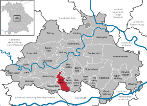
| Location of the municipality of Buxheim in the Eichstätt district | ||
  |
||

Buxheim is a municipality in the Upper Bavarian district of Eichstätt .
geography
The community is located on the southern Franconian Jura in the Altmühltal Nature Park in the Eichstätt district, about eight kilometers west of Ingolstadt .
Community structure
There are six officially named parts of the municipality (the type of settlement is given in brackets ):
- Buxheim ( parish village )
- Hessenhof ( wasteland )
- Moosbauer (wasteland)
- Moosmühle (wasteland)
- Reinboldsmühle (wasteland)
- Tauberfeld ( Kirchdorf )
The municipality consists of two districts (the associated parts of the municipality in brackets):
- Buxheim (with Moosbauer, Moosmühle, Hessenhof and Reinboldsmühle)
- Tauberfeld
Neighboring communities
| Nobility strike | Hitzhofen | |
| Wolkertshofen ( Nassenfels ) |
.svg)
|
Eitensheim |
| Pettenhofen (Ingolstadt) , Mühlhausen (Ingolstadt) , Dünzlau (Ingolstadt) | Gabel (Gaimersheim) |
history
In the hallway Sandbuck of the place were Mesolithic findings made. There is evidence of a Roman settlement west of Buxheim .
Pussenesheim , an eichstättisch-episcopal farm , is mentioned for the first time in a document dated February 5, 908 and was probably part of the basic equipment of the diocese of Eichstätt, which was established around 745 . For 1179 the place is proven to be owned by the Eichstätter cathedral chapter , confirmed in a document from Pope Alexander III. At the beginning of the 12th century, the place was called Puhsenshaim under Bishop Eberhard during an exchange of goods . Until the middle of the 13th century there was a local nobility; in 1204 a Sifrit von Bussensheim appears in a document. In 1305 the place was awarded to the bishop of Eichstätt Konrad II von Pfeffenhausen during the dispute over the Hirschberg inheritance - the Eichstätter patronage had died out with Gebhard VII von Hirschberg .
During the Thirty Years War the place was devastated and then rebuilt. In further wars, Buxheim was sacked in 1641 and 1704.
Buxheim was enlarged on April 1, 1971 to include the municipality of Tauberfeld. On the occasion of the district reform , which came into force on July 1, 1972, the Middle Franconian district of Eichstätt and Buxheim moved to the administrative district of Upper Bavaria . In 1983 there were 41 full-time and 28 part-time businesses with 1752 inhabitants in the predominantly agricultural-oriented town.
Population development
Between 1988 and 2018, the municipality grew from 2,591 to 3,732 by 1,141 inhabitants or 44%.


politics
Municipal council
The municipal council of Buxheim has 16 members.
- CSU : 6 seats
- SPD : 4 seats
- Free voters : 4 seats
- Bündnis 90 / Die Grünen-Bunte Ökologische Liste Buxheim: 2 seats
(As of: local elections on March 16, 2014 )
mayor
Since 2017, the mayor has been Benedikt Bauer, who has not been party to any party but has stood for the SPD.
coat of arms
|
|
Blazon : "In red over a lowered silver wavy bar, a floating silver bishop's staff, covered by an obliquely crossed silver sword and a golden flaming sword with a silver handle." |
Attractions
The Catholic parish church of St. Michael in the center of Buxheim was built in 1911 by the Munich architect Hans Schurr in neo-baroque forms. The stately tower of the predecessor church, built in 1629, has been preserved, the core of which dates from around 1340 and the upper floors of which were probably built by Giovanni Battista Camessina in the 17th century according to plans by the Eichstatt master builder Jakob Engel ; In 1735 the dome was repaired. In addition to the early classicist altars (around 1780, the figures probably by Joseph Anton Breitenauer ) , the furnishings include a baroque pulpit (around 1670/80), a group of carved figures of Saint Anne with Mary (around 1520) and two paintings from the secularized Notre-Dame monastery in Eichstätt by Josef Anton Glanschnig ( inscribed 1736). The neighboring rectory dates from the beginning of the 17th century, the benefit house from the 2nd half of the 18th century.
Up until 1919/20 there was a brewery owned by the Prince-Bishop in the center of Buxheim. This included a brewery , several barns and agricultural properties, as well as extensive property. In 1918 the brewery was sold into private hands and demolished around 1919/20. The last brewery owner was Otto Schanz . The prince-bishop's stone coat of arms, which was placed above the archway of the brewery building, is considered the last remnant of the brewery and found its existence when the new municipal office was built, set into the north wall above the main entrance. The coat of arms bears the inscription Joannes Anton DG Episcopus et 5. R. Imperii Princeps Eystetensis and is provided with the year 1729.
literature
- Collective sheet of the historical association Eichstätt 52 (1937), pp. 14, 40, 42; 59 (1961/62), p. 57f.
- Karl Zecherle: Churches and monasteries in the Eichstätt district , Eichstätt: Eichstätt district 1983, p. 94f.
- The Eichstätter space in past and present, Eichstätt: Sparkasse Eichstätt, 2nd expanded edition 1984, pp. 176–178 (Buxheim), 288 (Tauberfeld)
Web links
Individual evidence
- ↑ "Data 2" sheet, Statistical Report A1200C 202041 Population of the municipalities, districts and administrative districts 1st quarter 2020 (population based on the 2011 census) ( help ).
- ^ Buxheim local council. Buxheim municipality, accessed on June 5, 2020 .
- ^ Buxheim community in the local database of the Bavarian State Library Online . Bavarian State Library, accessed on September 14, 2019.
- ^ Wilhelm Volkert (ed.): Handbook of Bavarian offices, communities and courts 1799–1980 . CH Beck, Munich 1983, ISBN 3-406-09669-7 , p. 456 .
- ↑ http://www.buxheim.de/gemeirat.html
- ↑ Benedikt Bauer gets 64.5 percent , on www.donaukurier.de , accessed on November 6, 2017
- ^ Entry on the coat of arms of Buxheim (Upper Bavaria) in the database of the House of Bavarian History

Adelschlag | Altmannstein | Beilngries | Böhmfeld | Buxheim | Denkendorf | Dollnstein | Egweil | Eichstätt | Eitensheim | Gaimersheim | Großmehring | Hepberg | Hitzhofen | Kinding | Kipfenberg | Koesching | Lenting | Mindelstetten | Mörnsheim | Nassenfels | Oberdolling | Pförring | Pollen field | Schernfeld | Stammham | Titting | Walting | Wellheim | Wettstetten
Non-parish areas in the Eichstätt
Haunstetter Forst district