
Stammham (near Ingolstadt)
| coat of arms | Germany map | |
|---|---|---|

|
Coordinates: 48 ° 51 ' N , 11 ° 28' E |
|
| Basic data | ||
| State : | Bavaria | |
| Administrative region : | Upper Bavaria | |
| County : | Eichstatt | |
| Height : | 483 m above sea level NHN | |
| Area : | 39.04 km 2 | |
| Residents: | 4063 (Dec. 31, 2019) | |
| Population density : | 104 inhabitants per km 2 | |
| Postcodes : | 85134, 85092 | |
| Area code : | 08405 | |
| License plate : | EGG | |
| Community key : | 09 1 76 161 | |
| Community structure: | 5 parts of the community | |
| Address of the municipal administration: |
Nürnberger Str. 3 85134 Stammham |
|
| Website : | ||
| Mayoress : | Maria Weber ( CSU ) | |
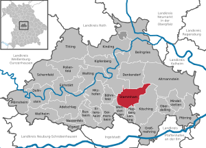
| Location of the municipality of Stammham in the district of Eichstätt | ||
  |
||

Stammham is a municipality in the Upper Bavarian district of Eichstätt .
geography
Stammham is located in the Ingolstadt region (about ten kilometers north of the city), but is part of the Eichstätt district.
The municipality has five officially named municipal parts (the type of settlement is given in brackets ):
- Appertshofen ( parish village )
- Köschinger Waldhaus (wasteland)
- Neuhau (wasteland)
- Stammham (parish village)
- Westerhofen ( Kirchdorf )
The districts of Stammham and Westerhofen form a common center and are completely merged with one another.
history
Until the church is planted
Celtic and Roman graves have been found in the vicinity of Stammham . In the forest to the west there is a large Keltenschanze. There was a Roman villa in the municipality of Westerhofen.
Stammham was first mentioned in a document in 1296, when Gebhard VII, the last Count of Hirschberg , handed over the patronage rights of the Stammham church to the Rebdorf monastery in the Eichstätt monastery . In 1326 the place was raised to a parish . Only so much is known about the ownership history of the place that in 1411 Sweiker von Gundelfingen sold the village with his rights to Friedrich and Kunrad Roßthaler , who ceded it to Erhard Muggenthaler von Schloss Sandersdorf in the same year . Muggenthaler received in 1418 by the Emperor Sigismund the high courts for his new possession awarded. In 1446 Duke Albrecht III bought. this right from Jobst Muggenthaler. The lower rights, which were still at Eichstätt, were acquired by Duke Ludwig the Rich from Prince-Bishop Wilhelm von Reichenau in 1478 . Stammham, now finally incorporated into the Duchy of Bavaria, became the seat of the Stammham-Etting nursing court six years later and belonged to the Munich Rent Office of the Electorate . As early as 1750 a water pipe was laid from Stammham to Hepberg . In 1818 came the present municipality Stammham.
In the First World War 26 men from Stammham and Westerhofen lost their lives, in the Second World War there were 58. From 1951 to 1955 the water supply was built.
Incorporations
In 1830 Westerhofen was incorporated into Stammham . From 1937 to 1947 land consolidation was carried out; the population at that time was around 850. On May 1, 1978, the municipality of Appertshofen was incorporated.
Population development
Between 1988 and 2018, the municipality grew from 2,631 to 4,061 by 1,430 inhabitants or 54.4%.
- 1961: 1487 inhabitants
- 1970: 1892 inhabitants
- 1984: 2402 inhabitants
- 1987: 2547 inhabitants
- 1991: 2793 inhabitants
- 1995: 2989 inhabitants
- 2001: 3385 inhabitants
- 2005: 3525 inhabitants
- 2010: 3687 inhabitants
- 2015: 3989 inhabitants
Religions
The catholic parish Stammham belongs to the deanery Pförring in the diocese of Regensburg . The pastor of Stammham is also responsible for the parish of Appertshofen and the church in Westerhofen. The Evangelical Lutheran Christians belong to the Evangelical Lutheran parish of St. Johannes, whose area extends from the Pius district of Ingolstadt to the Köschinger Forest and includes the villages of Etting , Wettstetten , Echenzell , Stammham and Appertshofen.
politics
Municipal council
The local council of Stammham has 16 members.
- CSU : 6 seats (40.66%)
- SPD : 2 seats (11.61%)
- Greens : 2 seats (11.41%)
- Independent electorate : 4 seats (25.55%)
- Non-party voters : 2 seats (10.77%)
The turnout was 70.27%.
(Status: local election on March 15, 2020)
Mayoress
Maria Weber from the CSU has been mayor since May 1, 2020. She was elected with 60.69% of the vote and is the successor to Hans Meier (independent electorate), who was mayor from May 1, 1990 to April 30, 2020 and was no longer a candidate.
tax income
The municipal tax revenue amounted to € 2.35 million in 2013, of which € 0.20 million (net) was trade tax revenue.
Culture and sights


Stammham
After the Augustinian Canons Rebdorf near Eichstätt had received the patronage rights for the church of Stammham, in 1295 there was talk of a church in "Steinheim" for the first time. There are no sources on the building history of the medieval church. After the Thirty Years War the church had to be repaired in 1657, 1668 and 1677; three new altars were erected. In 1701 lightning struck the church tower, which then had to be rebuilt. In the Baroque period , the church was replaced by a new building in 1737–40, built by Ingolstadt's master city mason Michael Anton Prunthaller (1684–1750). In 1904/05 the altars were changed and the nave was decorated with stucco and ceiling paintings. The current parish church of St. Stephanus, in which the baroque church is integrated as a choir, was built 1973–75 by the architect Josef Naumann from Regensburg; the glass windows made by Peter Recker (1913–2003) from Eichstätt. The church tower from 1701/02 is Gothic in its substructure and has a Romanesque core. The top of the tower comes from the camera builder Joseph Deiglmayer.
In the integrated old church, a ceiling painting shows the stoning of the church patron , the ordination of the deacon , Notburga , Isidor and in the choir arch Christ Salvator , painted in 1903 by the church painter Josef Wittmann , who was born in Windischeschenbach in 1880. The high altar dates from the Baroque period, but contains Gothic sculptures from around 1510. The altarpiece was created by the Ingolstadt painter Johann Evangelist Hölzl , and two oval paintings inside the arch between the old and new churches were frescoed by Joseph Anton Hölzl in 1773.
.JPG)
Appertshofen

The village of Appertshofen lies in a shallow hollow of the Jura area sloping down towards the Danube and was probably surrounded by a body of water in the past, because the first church, built around 1200 and mentioned for the first time in 1350, was consecrated to "Our Lady Maria am See". The Church of the Visitation of the Virgin Mary was a branch church of Kösching from 1444 and a popular pilgrimage church until 200 years ago ; a spring that gushed there should help with eye ailments. The church burned down in 1580 and was rebuilt from 1581. During the Thirty Years War the village suffered great damage and the state of preservation of the church deteriorated. The strong population shrinkage during this time was compensated in the course of the restructuring of Bavaria under Elector Maximilian I, which followed the Peace of Westphalia, by moving people who had settled down . Their cultural influence is still noticeable today. In 1737, the church was rebuilt in a baroque style by Ingolstadt master mason Michael Anton Prunnthaller ; the baroque high altar did not come to Stammham from Hepberg until 1966 . In the high altar niche is the Gothic miraculous image , a Madonna with the baby Jesus . The ceiling fresco from 1720 shows Mary as the salvation of the sick . The church has a famous baroque organ , which was built in 1735 by Caspar König from Ingolstadt . A precious chasuble comes from the 18th century .
An old saying goes: "Appertshofen am See, Hitzhofen im Klee, Pettenhofen am Sand, three churches well known."


Westerhofen
The former Hofmark Westerhofen belonged to the parish of Kösching around 1000 and was first mentioned in a document in 1309. In the 16th century, the noble Bartholomäus Marendl built a castle, which was destroyed in the Thirty Years' War 1618–48 and rebuilt from 1670 and today serves as a farm. In 1879 the village with about 140 inhabitants was incorporated into Stammham. In 1983 the population had grown to 480.
The predecessor of the Church of St. Martin with its leaning tower was a Romanesque church that was consecrated in 1120/30. After it was destroyed in the Thirty Years War , today's church was built around 1700 and expanded to the west in 1834. It contains a third of Anna herself from the 16th century.
During excavations in 1856, the foundations of a large Roman villa were discovered west of Westerhofen . The highlight of the excavations is the mosaic floor with hunting scenes and animals exhibited in the Prehistoric State Collection in Munich . Even King Maximilian II came to Westerhofen in 1857 to inspect the site.
Architectural monuments
societies
In Stammham there are a total of 41 clubs and groups from different areas.
Economy and Infrastructure
Economy including agriculture and forestry
In 1998, according to official statistics, there were 25 employees in the field of agriculture and forestry, 124 in manufacturing and 69 in the field of trade and transport. In other economic areas, 60 people were employed at the place of work subject to social security contributions. There were a total of 1186 employees at the place of residence subject to social security contributions. There was one company in the manufacturing sector and six companies in the main construction sector. In addition, in 1999 there were 31 agricultural holdings with an agriculturally used area of 842 ha, of which 796 ha were arable land and 46 ha were permanent green space.
traffic
The A 9 motorway runs just east of Stammham and Appertshofen. The next driveway is Lenting (about five kilometers south). In the area of the municipality, the new Nuremberg – Ingolstadt line crosses under the federal autobahn 9 in the Stammham tunnel .
There are bus connections to Ingolstadt (lines 9226, 30 and N5 of the INVG ) and Beilngries (line 9226 of the RBA).
education
There are currently the following facilities in Stammham:
- One day nursery each in Stammham and Appertshofen
- Two kindergartens in Stammham, one in Appertshofen
- A primary school 1st to 4th grade
- A community library across from the church
- Curative educational day care center Forsthaus Stammham
Personalities
- Johann Kuffer (* 1947 in Appertshofen), lawyer, former judge at the Federal Court of Justice
literature
- J. Hartmann: Stammhamer and Westerhofen stories. In: Ingolstädter Heimatblätter 20 (1957), No. 7–8
- G. Brenninger: Furnishing the churches of the former district of Ingolstadt. In: Ingolstädter Heimatblätter 39 (1976), p. 31 ff.
- Hans J. Utz: Pilgrimage Church to Our Lady in Appertshofen. In: Pilgrimages in the Diocese of Regensburg, 1981, p. 93
- K. Zecherle: Churches and monasteries in the Eichstätt district, Eichstätt 1983, p. 39, 124
- The Eichstätter Raum in Past and Present , Eichstätt, 2nd expanded edition 1984, pp. 156 f., 286 f., 301 f.
- Klaus Mayer: Stammham - Appertshofen - Westerhofen. Heimatbuch, 1985
- Siegfried Hofmann: The church in Stammham. Their fates since the Thirty Years War. In: Collective sheet of the Historisches Verein Ingolstadt 84 (1975), pp. 131–152
- E. Ettel and Siegfried Hofmann: Appertshofen, Mariä Visitation . Regensburg: Schnell & Steiner 1981
- The churches of the parish of Stammham. Regensburg: Schnell & Steiner 2005, ISBN 3-7954-6528-1
Web links
- Entry on the coat of arms of Stammham (near Ingolstadt) in the database of the House of Bavarian History
Individual evidence
- ↑ "Data 2" sheet, Statistical Report A1200C 202041 Population of the municipalities, districts and administrative districts 1st quarter 2020 (population based on the 2011 census) ( help ).
- ^ Community Stammham in the local database of the Bavarian State Library Online . Bavarian State Library, accessed on September 14, 2019.
- ↑ http://www.stammham.de/Geschichte.aspx
- ^ Federal Statistical Office (ed.): Historical municipality directory for the Federal Republic of Germany. Name, border and key number changes in municipalities, counties and administrative districts from May 27, 1970 to December 31, 1982 . W. Kohlhammer, Stuttgart / Mainz 1983, ISBN 3-17-003263-1 , p. 599 .
- ↑ Municipal Council - Municipal Council. Retrieved May 25, 2020 .
- ↑ Mayor - Mayor. Retrieved May 13, 2020 .
- ^ Parish Stammham: clubs / groups. In: www.stammham.de. Retrieved October 17, 2016 .

Adelschlag | Altmannstein | Beilngries | Böhmfeld | Buxheim | Denkendorf | Dollnstein | Egweil | Eichstätt | Eitensheim | Gaimersheim | Großmehring | Hepberg | Hitzhofen | Kinding | Kipfenberg | Koesching | Lenting | Mindelstetten | Mörnsheim | Nassenfels | Oberdolling | Pförring | Pollen field | Schernfeld | Stammham | Titting | Walting | Wellheim | Wettstetten
Non-parish areas in the Eichstätt
Haunstetter Forst district