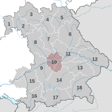
Ingolstadt planning region
The Ingolstadt planning region is one of a total of 18 planning regions in the Free State of Bavaria .
structure
The Ingolstadt planning region is located in the northern part of the Upper Bavaria administrative region. The following bodies are united in the regional planning association : the district-free city of Ingolstadt , the districts of Eichstätt , Neuburg-Schrobenhausen and Pfaffenhofen adIlm as well as the associated district communities.
Around 490,000 people live in the region on an area of 2,848 km². The main center of the region is the city of Ingolstadt with around 138,000 inhabitants . Corresponding middle areas are Eichstätt , Neuburg an der Donau , Schrobenhausen and Pfaffenhofen an der Ilm .
List of the largest municipalities
As of December 31, 2015
| Item | local community | district | Residents |
|---|---|---|---|
| 1 | Ingolstadt | IN | 132,438 |
| 2 | Neuburg on the Danube | ND | 29,182 |
| 3 | Pfaffenhofen on the Ilm | PAF | 25,226 |
| 4th | Schrobenhausen | ND | 16,753 |
| 5 | Eichstatt | EGG | 13,407 |
| 6th | Manching | PAF | 12,317 |
| 7th | Gaimersheim | EGG | 11,618 |
| 8th | Wolnzach | PAF | 11,355 |
| 9 | Geisenfeld | PAF | 10,930 |
| 10 | Koesching | EGG | 9,428 |
| 11 | Beilngries | EGG | 9,258 |
| 12 | Vohburg on the Danube | PAF | 8,120 |
| 13 | Reichertshofen | PAF | 8,066 |
| 14th | Altmannstein | EGG | 6,958 |
| 15th | Rohrbach | PAF | 5,936 |
history
In 1972 the Free State of Bavaria was divided into 18 planning regions on the basis of the Bavarian State Planning Act of 1970. The Regional Planning Association was established in 1973. The current association chairman is Christian Lösel , Lord Mayor of Ingolstadt.
A joint tariff of the transport companies in the Ingolstadt planning region has existed since September 2018.
Web links
Individual evidence
- ↑ https://www.citypopulation.de/php/germany-bayern_d.php Accessed on January 6, 2018
- ↑ You have reached your destination , Donaukurier from August 31, 2018; Accessed December 26, 2018
